Hackensack River facts for kids
Quick facts for kids Hackensack River |
|
|---|---|
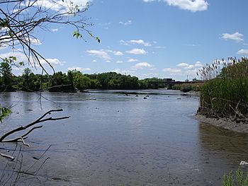
A view of the Hackensack River taken from the shore in Teaneck at low tide
|
|
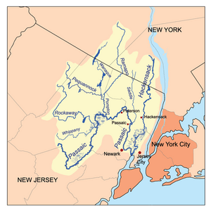
The Passaic and Hackensack watersheds
|
|
| Country | United States |
| State | New Jersey, New York |
| Counties | Hudson, NJ, Bergen, NJ, Rockland, NY |
| City | Hackensack, NJ |
| Physical characteristics | |
| Main source | West Haverstraw, Rockland County, New York, United States 120 ft (37 m) 41°11′00″N 73°59′24″W / 41.18333°N 73.99000°W |
| River mouth | Newark Bay Hudson County, New Jersey, United States 0 ft (0 m) 40°42′55″N 74°06′42″W / 40.71528°N 74.11167°W |
| Length | 54 mi (87 km) |
The Hackensack River is a river about 45 miles (72 km) long. It flows through parts of New York and New Jersey. This river eventually empties into Newark Bay, which is connected to New York Harbor. The land area that drains into the Hackensack River is called its watershed. This area includes suburbs near New York City. The river flows close to the Hudson River, separated by the New Jersey Palisades. It also runs through and drains the New Jersey Meadowlands. The lower part of the river can be used by boats up to the city of Hackensack. This area is very industrial. The Hackensack River was once one of the most polluted rivers in the United States. However, it has become much cleaner since the late 2000s.
Contents
Where Does the Hackensack River Flow?
The Hackensack River begins in southeastern New York. Its source is in Rockland County, in a place called Sweet Swamp. This is about 1 mile (1.6 km) south of West Haverstraw. The river flows southeast for a short distance. It then enters the Lake DeForest reservoir. This reservoir is less than 3 miles (5 km) from the Hudson River.
South of the dam, the river flows south, moving away from the Hudson. When it crosses into New Jersey, in northern Bergen County, it forms another reservoir called Lake Tappan. This is near River Vale.
South of Lake Tappan, the river winds its way southward. It flows through many suburban towns in New Jersey. Near Oradell, it forms the Oradell Reservoir. Here, several smaller streams join the river. These include the Dwars Kill, Cherry Brook, and Pascack Brook. Van Buskirk Island is a man-made island in this area.
South of the reservoir, the river flows past several towns. These include River Edge, Hackensack, Teaneck, Bogota, and Ridgefield Park. Here, it gets close to the Hudson River again. The Palisades ridge separates the two rivers.
At Little Ferry, a wide stream called Overpeck Creek joins the Hackensack. The river then flows south, becoming wider. It forms a large, winding tidal estuary through the Meadowlands. This area has many side streams and wetlands. South of North Bergen, the river forms the border between Bergen County and Hudson County.
Near Secaucus, Berrys Creek joins the river. The Hackensack then flows past the western edge of Jersey City. Finally, it meets the Passaic River between Jersey City and Kearny. Together, they form Newark Bay. Many bridges for trains and roads cross the river in the Meadowlands.
A Look Back: History of the Hackensack River
The name "Hackensack" comes from the Lenape language. The Lenape were Native Americans who lived in this area. The name Achinigeu-hach or Ackingsah-sack means "flat meeting of streams" or "stony ground." Early Dutch settlers faced challenges from the Lenape. This made it hard for them to move west into the valley until the late 1600s.
The river was a great source of food for both Native Americans and European settlers. They caught many fish like herring, shad, and striped bass.
When Europeans first settled, the river's watershed was home to several Lenape groups. These included the Rumachenanck, Tappan, and Hackensack tribes. The Hackensack tribe got its name from a camp near where Overpeck Creek joins the river. European settlement began in the mid-1600s. This area was part of the New Netherland colony. It was called Achter Kol, meaning "rear pass" or "behind the ridge." This name described the valleys west of the Hudson Palisades. These valleys offered a path to hunting grounds further north.
The Hackensack River and the surrounding Meadowlands made travel difficult. These wetlands helped the Continental Army escape in 1776. This was after they lost several battles to the British army across the Hudson River. The river later became a protective barrier. It allowed George Washington's army to camp safely in the nearby hills near Morristown.
Changes Over Time: How Humans Affected the River
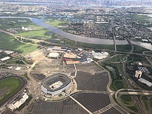
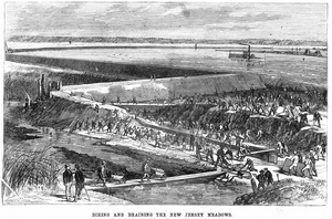
In the 1800s, people started changing the land around the Hackensack Meadowlands more and more. They cut down forests and built roads, railroads, and ditches. They also filled in wetlands. The Second Industrial Revolution brought many factories and chemical plants to the area. This happened in the late 1800s and early 1900s.
As more people and businesses came, the river became very polluted. Dirty water came from city sewage and factories. In the 1900s, untreated sewage from towns and cities added a lot of pollution. The first sewage treatment plant that cleaned water well opened in the 1950s. More treatment plants were built later. Even in the 2000s, some communities still have old sewer systems. These systems can release untreated sewage into the river during heavy rain.
Building new sources of drinking water also changed the river. The Oradell Reservoir dam was built in 1921. This dam changed the lower river from a flowing stream into a brackish estuary. This means it became a mix of fresh and salt water. This change allowed ocean animals to move into the river. After World War II, more roads and highways were built. This included the New Jersey Turnpike in 1952. The Meadowlands Sports Complex was also built in the 1970s.
By the 1960s, much of the lower river was very cloudy and had low oxygen. It was like a "dead zone." Only the toughest fish, like the mummichog, could survive. Chemical companies dumped a lot of waste into Berrys Creek during the 1900s. This caused very high levels of harmful chemicals in the riverbed. Three spots along the creek are now "Superfund" sites. This means they are very polluted and need big cleanup efforts. These cleanups are still happening today.
The river has gotten somewhat better since the late 2000s. This is because fewer factories are in the area. Also, rules like the Clean Water Act helped. Local groups also worked hard to protect the river. People can now fish for fun again, but it's often best to catch and release the fish. This is because there are still warnings about eating fish from the river. Pollution from city streets, sewage overflows, and old waste sites still affect the river's water quality.
The future of the wetlands around the lower river has been a debate. Some groups want to build on the land, while others want to protect it. The Hackensack Meadowlands Development Commission was created in 1968. Its job was to manage building and protect nature. This commission later merged with another group in 2015.
Smaller Streams Joining the River: Tributaries
New Jersey
- Berrys Creek
- Bashes Creek
- Cherry Brook
- Moonachie Creek
- Mill Creek
- Cromakill Creek
- Bellmans Creek
- Losen Slote
- Overpeck Creek
- Coles Brook
- French Brook
- Hirshfeld Brook
- Dwars Kill
-
- Tappan Run
- Pascack Brook
- Holdrum Brook
-
- Hillsdale Brook
- Cherry Brook
New York
- Nauraushaun Brook Nanuet, New York
- East Branch Hackensack River
- Toms Creek
- West Branch Hackensack River
 | Frances Mary Albrier |
 | Whitney Young |
 | Muhammad Ali |


