
Little Ferry, New Jersey facts for kids
Quick facts for kids
Little Ferry, New Jersey
|
||
|---|---|---|
|
Borough
|
||

Winant Avenue Bridge
|
||
|
||

Location of Little Ferry in Bergen County highlighted in red (left). Inset map: Location of Bergen County in New Jersey highlighted in orange (right).
|
||

Census Bureau map of Little Ferry, New Jersey
|
||

Little Ferry, New Jersey
Location in Bergen County, New Jersey

Little Ferry, New Jersey
Location in New Jersey

Little Ferry, New Jersey
Location in the United States
|
||
| Country | ||
| State | ||
| County | Bergen | |
| Incorporated | September 18, 1894 | |
| Government | ||
| • Type | Borough | |
| • Body | Borough Council | |
| Area | ||
| • Total | 1.67 sq mi (4.32 km2) | |
| • Land | 1.48 sq mi (3.83 km2) | |
| • Water | 0.19 sq mi (0.50 km2) 11.44% | |
| Area rank | 433rd of 565 in state 55th of 70 in county |
|
| Elevation | 3 ft (0.9 m) | |
| Population
(2020)
|
||
| • Total | 10,987 | |
| • Estimate
(2023)
|
10,914 | |
| • Rank | 228th of 565 in state 35th of 70 in county |
|
| • Density | 7,438.7/sq mi (2,872.1/km2) | |
| • Density rank | 61st of 565 in state 18th of 70 in county |
|
| Time zone | UTC−05:00 (Eastern (EST)) | |
| • Summer (DST) | UTC−04:00 (Eastern (EDT)) | |
| ZIP Code |
07643
|
|
| Area code(s) | 201 | |
| FIPS code | 3400340680 | |
| GNIS feature ID | 0885281 | |

Little Ferry is a small town, called a borough, located in Bergen County, in the state of New Jersey. In 2020, about 10,987 people lived there. The town's name comes from an old ferry crossing that was very important a long time ago.
Contents
History of Little Ferry
Little Ferry became an official borough on September 18, 1894. This happened during a time when many new boroughs were being created in Bergen County.
The Important Ferry Crossing
Back in the colonial days, Little Ferry was a key spot. It had a ferry that helped people cross the river between the towns of Bergen and Hackensack. This ferry started operating in 1659 and was used until 1826. After that, a bridge was built to replace it.
Gethsemane Cemetery
Gethsemane Cemetery is an old burial ground for African Americans. It opened in 1860 and was used until 1924. This historic site was added to the National Register of Historic Places in 1994.
The Fox Film Vault Fire
In 1937, a big fire happened at a film storage building in Little Ferry. This building belonged to 20th Century-Fox. Old movies were stored on nitrate film, which can catch fire easily. Hot weather and not enough air flow caused the fire.
Rosie's Diner Connection
You might know Rosie's Diner from TV commercials! This diner, which used to be called Farmland Diner, was used for filming Bounty paper towel commercials in the 1970s. The commercials featured an actress named Nancy Walker as Rosie the Waitress.
Geography of Little Ferry
Little Ferry covers about 1.67 square miles (4.32 square kilometers). Most of this area is land, but about 11% is water.
The borough is located near where the Hackensack River and Overpeck Creek meet. This area is part of the New Jersey Meadowlands. Little Ferry shares its borders with several other towns in Bergen County. These include Hackensack, Moonachie, Ridgefield, Ridgefield Park, South Hackensack, and Teterboro.
Education in Little Ferry
Students in Little Ferry attend schools run by the Little Ferry Public Schools district. This district serves students from pre-kindergarten up to eighth grade.
Local Schools
The district has two schools:
- Washington Elementary School: For students in PreK through 4th grade.
- Memorial Middle School: For students in 5th through 8th grade.
These two school buildings are located across the street from each other.
High School Education
Little Ferry does not have its own high school. After eighth grade, students go to Ridgefield Park High School in Ridgefield Park. This arrangement has been in place since 1953.
County Technical Schools
Students in Little Ferry can also apply to special high school programs. These are offered by the Bergen County Technical Schools. These schools include:
- Bergen County Academies in Hackensack.
- Applied Technology High School in Paramus.
- Bergen County Technical High Schools in Teterboro and Paramus.
These programs offer unique learning experiences, and students are chosen through an application process.
Transportation in Little Ferry
Little Ferry has several roads and ways to get around.
Roads and Highways
_just_west_of_Bergen_County_Route_124_(Bergen_Turnpike)_in_Little_Ferry,_Bergen_County,_New_Jersey.jpg)
The town used to have a busy traffic circle called the Little Ferry Circle. This circle connected U.S. Route 46 and Bergen Turnpike. It was built in 1933. Over the years, this circle had many accidents. To make it safer, the circle was changed into a straight intersection with turning lanes. This change also helped with flooding on the highway.
Public Transportation
- Buses: NJ Transit buses provide service from Little Ferry to Midtown Manhattan. There are also local bus routes.
- Seaplane Base: Little Ferry has a seaplane base on the Hackensack River. This is a place where small planes that can land on water take off and land.
Notable People from Little Ferry
Many interesting people have lived in or are connected to Little Ferry:
- Tom Boisture (1931–2011), a coach and scout for professional football teams.
- Oscar Gamble (1949–2018), a former professional baseball player.
- Phil Hawes (born 1989), a professional mixed martial artist.
- Bill Lovett (1894–1923), a person from the early 20th century.
- Ambar Lucid (born 2001), a singer-songwriter and musician.
- Margherita Marchione (1922–2021), a nun, writer, and teacher.
- Pete Michels (born 1964), an animation director who worked on shows like The Simpsons.
- Chico Resch (born 1949), a retired professional ice hockey goalie and sportscaster.
- Buddy Valastro (born 1977), the star of the TV show Cake Boss. He received the "keys to the city" of Little Ferry in 2010.
Images for kids
-
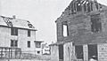
A building on Main Street after the Fox film vault fire.

See also
 In Spanish: Little Ferry para niños
