
New York Harbor facts for kids


New York Harbor is a very important natural harbor located where the Hudson River meets New York Bay. From there, it flows into the Atlantic Ocean on the East Coast of the United States. It's one of the biggest natural harbors in the world!
Even though the official U.S. Board on Geographic Names doesn't use the exact term "New York Harbor," it's a widely used name. It's important for history, government, business, and the environment.

Contents
History of New York Harbor
Early Days and Settlements
The Lenape people lived around New York Harbor in the 1500s. They used the waterways for fishing and traveling.
In 1624, the first permanent European settlement began on Governors Island. Eight years later, another started in Brooklyn. Soon, ferries connected these places.

In 1648, the Dutch leader Peter Stuyvesant ordered the first dock built on the Manhattan side of the East River. This dock, called Schreyers Hook Dock, helped New York become a major port. It was important first for the British colonies and then for the new United States.
By 1686, British officials gave the city control over its waterfront.
The 1800s: A Growing Port
_pg081_NEW_YORK_HARBOR,_FROM_EAST-RIVER_BRIDGE_(IN_1893).jpg)
In 1808, Lieutenant Thomas Gedney found a new, deeper channel into New York Harbor. Before this, ships had to wait for high tide to avoid sandbars. Gedney's Channel was deeper and shorter, making it much easier for large ships to enter the harbor. This was a huge help for ship owners and merchants.
The first American drydock was finished on the East River in 1824. With the arrival of steamships and the completion of the Erie Canal in 1825, New York's port grew very fast. It became the most important place for moving goods between the American interior and Europe.
By 1840, more people and goods passed through New York's port than all other major U.S. harbors combined. By 1900, it was one of the world's greatest international ports.

The Statue of Liberty stands on Liberty Island in the harbor. It reminds us of the many immigrants who came to the U.S. around 1900. Ellis Island, a main entry point, processed 12 million arrivals from 1892 to 1954. Many immigrants started new lives in the New York area, while others traveled across America.
The 1900s: World War II and Beyond


New York Harbor During World War II

When the United States entered World War II, German submarines began attacking merchant ships near the U.S. coast in 1942. The bright city lights of New York made it easy for U-boats to spot target ships at night. Some lights were dimmed, like those at Coney Island and the Sandy Hook Lighthouse.
New York Harbor was a very important starting point for convoys (groups of ships traveling together for safety) during the Battle of the Atlantic. Many U.S. merchant ships were lost during this time.
The harbor was busiest in March 1943. There were 543 ships waiting to join convoys or dock. The harbor had 750 piers, 1,100 warehouses, and 39 active shipyards, including the New York Naval Shipyard. This made New York Harbor the busiest in the world during the war.
After World War II
After the war, a group called the Waterfront Commission was set up in 1953. Its job was to prevent unfair or illegal activities at the port and make sure things were run properly.
In 2006, the port's passenger facility was planned to be managed by a company called Dubai Ports World.
Container Shipping and Air Travel

Today, the Port of New York and New Jersey is the largest port for importing oil and the third largest for container ships in the U.S. Since 1921, the port's commercial activities have been managed by the Port Authority of New York and New Jersey.
Since the 1950s, most of the commercial shipping has moved to the Port Newark–Elizabeth Marine Terminal in Newark Bay. This is now the largest container port on the Eastern Seaboard.
While the port is less important for passenger travel by ship, the Port Authority still runs the three main airports in the area: LaGuardia, JFK (formerly Idlewild), and Newark.
Ferries and Cruise Ships
The harbor is still used by several cruise lines for vacations. Many ferries also carry commuters and tourists. The Staten Island Ferry is a famous free ferry operated by the New York City Department of Transportation. Other passenger ship facilities include the New York Passenger Ship Terminal, the Brooklyn Cruise Terminal, and MOTBY in Bayonne.
Images for kids
-
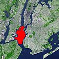
New York Harbor/Upper New York Bay in red. It is connected to Lower New York Bay on the south by the Narrows. Ellis Island (north) and Liberty Island (south) are shown in the northwest corner of the bay.
-
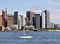
Manhattan, across the bay from Liberty State Park
-
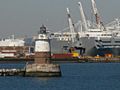
Robbins Reef Light, MOTBY, and Port Jersey
-
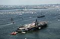
Liberty Weekend 1986
-
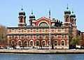
Ellis Island


See also
 In Spanish: Puerto de Nueva York para niños
