Castello Plan facts for kids

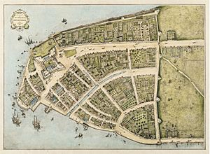
The Castello Plan is a very old map of what is now the Financial District in Lower Manhattan, New York City. Its official Dutch name means "Picture of the City of Amsterdam in New Netherland." This map shows the area as it looked in 1660.
The map was originally drawn by Jacques Cortelyou, a surveyor in New Amsterdam. New Amsterdam was the old name for what later became New York City. The map we see today is a copy made around 1665-1670. The original map by Cortelyou is now lost.
Contents
The Map's Journey
From Amsterdam to Italy
Around 1667, a mapmaker named Joan Blaeu added this plan to a collection of maps. He sold this collection, called an atlas, to Cosimo III de' Medici, Grand Duke of Tuscany. This sale likely happened in Amsterdam, in the Netherlands. It's believed that Blaeu never actually visited New Netherland himself.
Rediscovery and Naming
The map stayed in Italy for many years. In 1900, it was found at a place called the Villa di Castello near Florence. When it was printed in 1916, it was given the name "Castello Plan."
An Important Historical Record
The Castello Plan is a very important historical document. It helps us understand what early New York City looked like. It is studied in detail in a large book series called The Iconography of Manhattan Island.
The Castello Plan Today
You can find a monument dedicated to the Castello Plan in Lower Manhattan at Peter Minuit Plaza. There's even a tavern in Brooklyn named "The Castello Plan." The actual map is usually kept in Florence, Italy, at the Laurentian Library. However, it was shown in New York City at the New-York Historical Society in 2024.
See also
 In Spanish: Plano de Castello para niños
 | Roy Wilkins |
 | John Lewis |
 | Linda Carol Brown |


