
Upper New York Bay facts for kids

Upper New York Bay, also called Upper Bay or New York Harbor, is a very important part of the Port of New York and New Jersey. It is surrounded by parts of New York City like Manhattan, Brooklyn, and Staten Island. It also borders cities in New Jersey such as Jersey City and Bayonne.
Contents
Exploring Upper New York Bay
Upper New York Bay gets its water from the Hudson River, which is sometimes called the North River. It also connects to the Gowanus Canal.
Waterways and Connections
The bay connects to other important waterways:
- To the south, it links to Lower New York Bay through a narrow passage called the Narrows.
- To the west, it connects to Newark Bay through the Kill Van Kull.
- To the east, it joins Long Island Sound through the East River. Even though it's called a river, the East River is actually a tidal strait, meaning ocean tides flow through it.
The Hudson River's water flows through Upper New York Bay and out to the ocean through the Narrows. The main path for ships in the harbor is called the Anchorage Channel.
Islands in the Bay
Several islands are located in Upper New York Bay:
- Governors Island is near where the East River meets the bay.
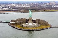
- Ellis Island and Liberty Island are famous islands.
- Robbins Reef is also in the bay.
These islands sit on a large underwater reef. This reef used to have huge oyster beds. People ate these oysters until pollution sadly destroyed the beds in the late 1800s.
A Place of History and Trade
Upper New York Bay has always been very important for trade and business in the New York metropolitan area. The Statue of Liberty National Monument stands in the bay, reminding us of the many immigrants who arrived here in the late 1800s and early 1900s.
Since the 1950s, most large container ships now use the Kill Van Kull to reach the Port Newark–Elizabeth Marine Terminal. This terminal makes it easier to move goods from ships to trucks or trains. Because of this change, many waterfront businesses around Upper New York Bay closed down. However, some important shipping activities still happen at places like Red Hook and Port Jersey.
Fun on the Water
Today, Upper New York Bay is also a popular place for fun activities. People enjoy sailing and kayaking here. Liberty State Park opened in 1976 and offers great views of the bay.
The Staten Island Ferry is a well-known boat ride that crosses the bay. It travels between Manhattan (near Battery Park) and Staten Island. Other boats, run by NY Waterway, also cross the bay.
The bay is home to many different kinds of marine animals. People often go fishing here for striped bass and bluefish.
Gallery
-
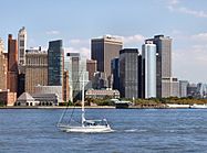
Manhattan, seen from Liberty State Park across the bay.
-
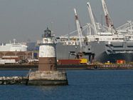
Robbins Reef Light, with MOTBY and Port Jersey in the background.
-
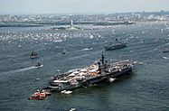
A view of the bay during Liberty Weekend in 1986.
-
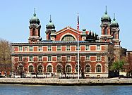
A close-up view of Ellis Island.
-
The famous Statue of Liberty.


See also
 In Spanish: Puerto de Nueva York para niños
