
New York metropolitan area facts for kids
Quick facts for kids
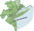
New York metropolitan area
New York–Newark–Bridgeport, NY, NJ, CT, PA
|
|
|---|---|

|
|

Location within the United States
|
|
| National | United States |
| States | |
| Principal cities | New York City (Brooklyn, Queens, Manhattan, The Bronx, Staten Island) Newark Jersey City Yonkers Paterson Bridgeport Elizabeth Stamford New Haven Allentown Waterbury Edison Norwalk Trenton Danbury New Rochelle Mount Vernon White Plains Passaic Woodbridge |
| Area | |
| • Total | 13,318 sq mi (34,490 km2) |
| Population
(2013)
|
|
| • Total | 23,632,722 (1st) |
| • Density | 1,876/sq mi (724/km2) |
| Time zone | UTC-5 (Eastern Time Zone) |
| Area code(s) | 201, 203, 212, 215, 267, 272, 347, 475, 484, 516, 518, 551, 570, 609, 610, 631, 646, 718, 732, 845, 848, 860, 862, 908, 914, 917, 929, 973 |
| Highest elevation 4,180 ft/1,274 m (Slide Mountain (Ulster County, New York), in the Catskill Mountains). Lowest elevation 0 ft/0 m (sea level) at the Atlantic Ocean, Long Island Sound, and at Hudson River estuary waterways. |
|
The New York metropolitan area is a huge region that includes New York City and all the towns and cities around it. It stretches across parts of New York, New Jersey, Connecticut, and even Pennsylvania. This area is like a giant connected community where millions of people live, work, and go to school.
It is the most populated area in the United States. It's also one of the largest built-up areas (meaning lots of buildings and roads) in the whole world. In North America, it's the biggest one!
Contents
- History of the New York Area
- Geography of the New York Metropolitan Area
- Subregions of the Area
- New York City: The Heart of the Region
- Long Island: Beaches and Suburbs
- Northern New Jersey: Cities and Green Spaces
- Central New Jersey: Capital and University Life
- Hudson Valley: Scenic Beauty and Growing Communities
- Western Connecticut: Affluent Towns and Universities
- Pennsylvania Counties: Poconos and Commuter Towns
- Main Cities in the Region
- Climate in the New York Area
- Subregions of the Area
- People and Cultures
- Economy of the New York Area
- Education in the New York Area
- Transportation in the New York Area
- Culture and Life
- Images for kids
- See also
History of the New York Area
How the Land Was Formed
Long ago, a huge sheet of ice, over 1,000 feet thick, covered this region. As it moved, it scraped away soil, leaving the strong rock foundation we see today. This ice also helped create Long Island and Staten Island.
Early Days and European Arrival
Before Europeans came, Native Americans, especially the Lenape people, lived here. They used the many rivers and bays for fishing and trading. In 1524, Giovanni da Verrazzano was the first European to explore the waters, but he didn't land.
Later, in 1609, Henry Hudson visited for the Dutch. A settlement was built on Manhattan Island. In 1626, the Dutch named it New Amsterdam. But in 1664, England took control and renamed it New York, after the Duke of York.


Growth and Importance
New York became a busy trading center. Many different groups of people came to live here, including Africans, Jews, and Portuguese. The area's natural harbor, formed by New York Bay and the Hudson River, was perfect for ships.
During the American Revolution, New York was very important for the British navy. Many battles were fought here. The British held New York City until the war ended in 1783. From 1785 to 1790, New York City was even the capital of the United States! Since 1790, it has been the country's largest city. In 1792, the New York Stock Exchange was created, which is now a very important place for business.


A Welcoming Place for Immigrants
The Statue of Liberty greeted millions of people coming to America by ship in the late 1800s and early 1900s. New York needed many workers, and the city welcomed different cultures. German, Irish, and Italian immigrants were some of the largest groups. Today, their families still live in the region.
Famous cultural places like the Metropolitan Museum of Art and the American Museum of Natural History were built. By 1884, over 70% of all goods leaving the country by ship went through New York's ports. In 1898, the five main parts of New York City – The Bronx, Brooklyn, Manhattan, Queens, and Staten Island – joined together to form one big city.
Modern Times and Challenges
The New York City Subway started running in 1904, making it easier for people to travel. Big train stations like Grand Central Terminal also helped towns outside the city grow.
The Great Depression in the 1930s brought hard times, with many people losing jobs. After 1950, many people started moving from the city to the suburbs. Businesses also moved. The city faced challenges, but it also saw the building of the original World Trade Center, which was once the tallest building in the world.
In the 1980s, the city's economy grew again. Crime, which had been a problem, began to drop a lot in the 1990s and continued to decline into the 2000s.


A very sad event happened on September 11, 2001. Two planes crashed into the World Trade Center towers, causing them to fall and nearly 3,000 people to die. After this, many businesses left Lower Manhattan, but new tall buildings and homes have been built there since.
In 2012, Hurricane Sandy caused a lot of damage to the area. It brought huge storm surges, flooding, and strong winds. Millions of people lost power. The storm caused billions of dollars in damage. This led to talks about building walls and barriers to protect the coast from future storms.

Geography of the New York Metropolitan Area
The New York metropolitan area is very large and diverse. It includes different types of land, from busy cities to quiet suburbs and even mountains.

Subregions of the Area
The area is often divided into several parts:
- New York City: This is the main center of the whole region. It has five parts called boroughs.
- Central and eastern Long Island: These are the areas of Nassau and Suffolk counties, east of New York City.
- North Jersey: The northern part of New Jersey.
- Central Jersey: The middle part of New Jersey.
- Hudson Valley: This area is north of New York City in New York State.
- Western Connecticut: Includes Fairfield, New Haven, and Litchfield counties in Connecticut.
- Lehigh Valley: Parts of Pennsylvania and New Jersey.
- Southern and Eastern Poconos: Parts of Pennsylvania.
New York City: The Heart of the Region
New York City is the cultural and economic center of the metropolitan area. It has five boroughs: Brooklyn, Queens, Manhattan, The Bronx, and Staten Island. These all became one city in 1898. With over 8.5 million people in 2015, New York is the most crowded major city in the United States.
New York City is a global power city. This means it has a big impact on business, money, media, art, and fashion around the world. It's also home to the United Nations Headquarters, making it important for international talks. Many people call it the cultural and financial capital of the world.
Long Island: Beaches and Suburbs


Long Island is an island off the coast of New York. It has four counties: Kings (which is Brooklyn) and Queens (which is Queens) in the west, and Nassau and Suffolk in the east. When people say "Long Island," they usually mean Nassau and Suffolk counties, which are mostly suburban.
Long Island is the most populated island in any U.S. state. Many people from New York City live on Long Island. It's also famous for its beaches, boating, and parks. In the summer, many famous and wealthy people visit or live in beautiful homes here.
Northern New Jersey: Cities and Green Spaces

Northern New Jersey includes counties like Bergen, Essex, and Hudson. It has some of New Jersey's largest cities: Newark, Jersey City, Paterson, and Elizabeth.
This region has different types of land, from wet areas to mountains and valleys. It has many highways and train services, mostly run by New Jersey Transit. Newark Liberty International Airport, the second busiest airport in the New York City area, is also here.
Central New Jersey: Capital and University Life


Central New Jersey is the middle part of the state. It includes Trenton, which is the capital city of New Jersey. Princeton, home to Princeton University, is also in this area. A big part of the Jersey Shore (famous beaches) is here too.
Hudson Valley: Scenic Beauty and Growing Communities


The Hudson Valley is known for its hills, beautiful scenery, and charming small towns. It's located north of New York City, along the Hudson River. Counties like Westchester, Putnam, Rockland, and Orange are part of this area.
The New Tappan Zee Bridge connects Westchester and Rockland counties. Many people here use the Metro-North Railroad to travel to work. Southern Westchester has more crowded areas and cities like Yonkers and White Plains. The Hudson Valley is growing fast because housing costs are high in New York City.
Western Connecticut: Affluent Towns and Universities

Fairfield, New Haven, and Litchfield counties are in western Connecticut. This area is known for its wealthy towns. Most of Connecticut's largest cities are in New Haven County (home to Yale University) and Fairfield County. The land is flat near the coast but becomes hilly further inland.
Pennsylvania Counties: Poconos and Commuter Towns

Monroe and Pike counties in northeastern Pennsylvania are part of this metropolitan area. These counties are growing quickly. Many people who live here travel to jobs in Northern New Jersey and New York City. They are largely in the Pocono Mountains and have many state parks.
The Lehigh Valley (Carbon, Lehigh, and Northampton counties) is also part of this area. It's important for transportation between New York City and other parts of Pennsylvania. Cities like Allentown, Bethlehem, and Easton are here.
Main Cities in the Region
The New York metropolitan area includes many important cities. Here are some of the largest:
- New York City: 8,175,133 people
- Hempstead, New York: 759,757 people
- Newark, New Jersey: 277,140 people
- Jersey City: 247,597 people
- Yonkers: 195,976 people
- Paterson: 146,199 people
- Bridgeport: 144,229 people
- Elizabeth: 128,640 people
- New Haven: 129,779 people
- Allentown: 118,032 people
- Waterbury: 109,272 people
- Stamford: 122,643 people
- Trenton: 84,913 people
Climate in the New York Area
Summers are usually hot and humid. Temperatures can often go above 90°F (32°C). Warm weather typically starts in mid-May and lasts until early October. Summers also have quick, strong thunderstorms.
Winters are cool to cold, with a mix of rain and snow. The Atlantic Ocean helps keep the area warmer than other places inland. Sometimes, warm days with temperatures above 50°F (10°C) can happen in winter.
Hurricanes and tropical storms have hit the area before, but it's rare for them to hit directly. Coastal areas have been affected by big storm surges. Inland areas have seen heavy rain and flooding from these storms.
People and Cultures


In 2010, the metropolitan area had over 22 million people. The population is very diverse, with people from many different backgrounds and cultures living together.
Economy of the New York Area

The economy of the New York City region is the largest in the United States and one of the most important in the world. Key industries include finance, international trade, media, real estate, education, fashion, entertainment, tourism, and technology.
Living here can be expensive, as the cost of living is one of the highest in the United States.
Wall Street: A Global Financial Hub

New York City is a major center for the financial industry, often called Wall Street. It's known as one of the most powerful economic cities and a leading financial center globally. The New York Stock Exchange and NASDAQ, two of the world's largest stock exchanges, are located here.
Silicon Alley: Tech and Innovation

Silicon Alley is a name for the New York region's growing technology industries. This includes companies working with the Internet, new media, financial technology (fintech), and software. The area also has a growing biotechnology sector, supported by scientific research and funding.


Port of New York and New Jersey
The Port of New York and New Jersey is a huge port that handles a lot of goods. It includes waterways, airports, and roads for moving cargo. It's a major part of the economy for the whole metropolitan area. In 2010, over 4,800 ships came into the harbor, carrying goods worth more than $175 billion!
Clean Water for Millions
New York City gets its drinking water from a protected area in the Catskill Mountains. Because this area is so clean and has a natural water filtering system, New York is one of the few big cities in the U.S. that doesn't need to purify most of its drinking water with special plants.
Education in the New York Area
The New York metropolitan area has many excellent universities. Three Ivy League schools are here: Columbia University in Manhattan, Princeton University in New Jersey, and Yale University in Connecticut. These are ranked among the top universities in the U.S. and the world.
Other important universities include New York University, Rutgers University (the largest in the region), New York Institute of Technology, Hofstra University, and Fordham University. In Pennsylvania, Lehigh University is also a top school.
The New York City Department of Education is the largest school district in the United States, serving over 1.2 million students. The region also has many highly-rated public high schools.
Transportation in the New York Area
The New York City region has a very complex and large transportation system. Many people here use public transportation instead of driving. In 2013, only about 57% of workers drove alone, while nearly 19% used trains.
Rail Systems
About one-third of all people who use public transportation in the U.S. live in the New York City area. Two-thirds of the country's train riders are also here.
New York City Subway

The New York City Subway is one of the largest rapid transit systems in the world. It has many stations and long routes. It's also special because almost the entire system runs 24 hours a day, every day!
PATH Trains

The Port Authority Trans-Hudson (PATH) is a subway system that connects Manhattan in New York City with cities in northern New Jersey like Newark and Jersey City. PATH trains also run 24 hours a day, seven days a week.
Commuter Trains
The area is also connected by three main commuter train systems and Amtrak. These trains help people travel from towns outside New York City into the city for work.

Major Highways
Many highways serve the region, helping people drive around.


Buses
Several bus companies operate commuter buses that go into the Port Authority Bus Terminal in Manhattan. There are also many local bus services in New Jersey, New York, and Connecticut.
Major Airports
The three busiest airports in the New York metropolitan area are John F. Kennedy International Airport, Newark Liberty International Airport, and LaGuardia Airport. In 2016, over 130 million travelers used these airports. The airspace above the metropolitan area is the busiest in the country.
Culture and Life


New York City is often called the cultural capital of the world. The entire region has many important cultural places, with art shows and events that get attention from all over the world.
Sports Teams
The New York metropolitan area is home to the main offices of the National Football League, Major League Baseball, the National Basketball Association, the National Hockey League, and Major League Soccer. Four of the ten most expensive stadiums ever built are in this area. The New York metropolitan area has the most professional sports teams in these five leagues.
Here are some of the professional sports teams in the New York metropolitan area:
- Basketball (NBA):
- Brooklyn Nets (Brooklyn, New York City)
- New York Knicks (Manhattan, New York City)
- Women's Basketball (WNBA):
- New York Liberty (Manhattan, New York City)
- Baseball (MLB):
- New York Mets (Queens, New York City)
- New York Yankees (The Bronx, New York City)
- Soccer (MLS):
- New York City FC (The Bronx, New York City)
- New York Red Bulls (Harrison, NJ)
- Football (NFL):
- New York Giants (East Rutherford, NJ)
- New York Jets (East Rutherford, NJ)
- Hockey (NHL):
- New Jersey Devils (Newark, NJ)
- New York Islanders (Brooklyn, New York City)
- New York Rangers (Manhattan, New York City)
There are also many minor league and college sports teams throughout the region.
Images for kids
-
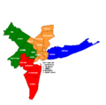
Map of the counties in the four divisions of the New York Metropolitan Area
-
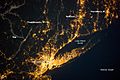
Nocturnal view of the New York City metropolitan area, one of the world's most brightly lit areas.
-
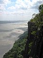
The cliffs of the New Jersey Palisades overlook the Hudson River.
-
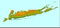
New York City and Long Island together are home to about 11 million people.
-
The New York-Newark, NY-NJ-CT-PA Combined Statistical Area.
-
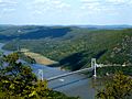
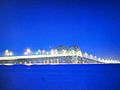
The Bear Mountain Bridge connecting Westchester and Orange Counties, New York.
-
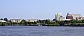
Downtown Trenton in Mercer County, New Jersey.
-
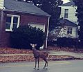
A deer in a suburban street (Highland Park, Middlesex County, NJ).
-
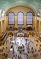
The main concourse of Grand Central Terminal, which opened in 1913.
-
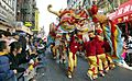
Chinatown, Manhattan. The New York metropolitan area is home to the largest population of Chinese people outside of Asia.
-
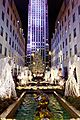
The Rockefeller Center Christmas Tree, a symbol of Christmas in the New York area.
-
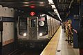
The New York City Subway is the world's largest rapid transit system.
-
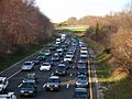
Heavy traffic on the Garden State Parkway in Wall Township, New Jersey.
-
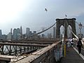
The Brooklyn Bridge.
-
The Verrazzano-Narrows Bridge, one of the world's longest suspension bridges.
-
The Great South Bay Bridge, in Suffolk County, Long Island.
-

Skyline of Six Flags Great Adventure in Jackson Township, New Jersey, the world's largest theme park in 2013.


_4.JPG)


See also
 In Spanish: Área metropolitana de Nueva York para niños
