Passaic, New Jersey facts for kids
Quick facts for kids
Passaic, New Jersey
|
||
|---|---|---|
|
City
|
||
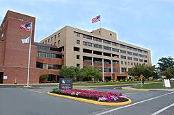
St. Mary's General Hospital in Passaic, New Jersey
|
||
|
||
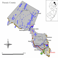
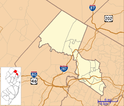
Location of Passaic in Passaic County highlighted in yellow (left). Inset map: Location of Passaic County in New Jersey highlighted in black (right).
|
||
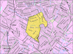
Census Bureau map of Passaic, New Jersey
|
||
| Country | ||
| State | ||
| County | Passaic | |
| Settled | 1679 | |
| Incorporated | April 2, 1873 | |
| Government | ||
| • Type | Faulkner Act (mayor-council) | |
| • Body | City Council | |
| Area | ||
| • Total | 3.24 sq mi (8.39 km2) | |
| • Land | 3.13 sq mi (8.11 km2) | |
| • Water | 0.11 sq mi (0.28 km2) 3.33% | |
| Area rank | 326th of 565 in state 11th of 16 in county |
|
| Elevation | 98 ft (30 m) | |
| Population
(2020)
|
||
| • Total | 70,537 | |
| • Estimate
(2023)
|
68,903 | |
| • Rank | 552nd in country (as of 2023) 16th of 565 in state 3rd of 16 in county |
|
| • Density | 22,514.2/sq mi (8,692.8/km2) | |
| • Density rank | 7th of 565 in state 1st of 16 in county |
|
| Time zone | UTC−05:00 (Eastern (EST)) | |
| • Summer (DST) | UTC−04:00 (Eastern (EDT)) | |
| ZIP Code |
07055
|
|
| Area code(s) | 973 | |
| FIPS code | 3403156550 | |
| GNIS feature ID | 0885342 | |
Passaic is a city in Passaic County, New Jersey. Its name comes from a Lenape word meaning "valley" or "place where the land splits." In 2020, Passaic was the 16th most populated city in New Jersey, with 70,537 people. It is also one of the most densely populated cities in the United States for its size.
Passaic is located north of Newark along the Passaic River. Dutch traders first settled the area in 1678. It was originally known as Acquackanonk Township.
Contents
History of Passaic
Passaic started as a Dutch settlement in 1679. It was first called Acquackanonk. During the 1800s, the city grew into a center for making textiles and metal products.
A busy trading area developed around a wharf on the Passaic River. This spot became known as Acquackanonk Landing. In 1854, Alfred Speer helped change the village's name to Passaic Village. He convinced the U.S. Postmaster General to use the new name.
Passaic became an official village in 1871 and a city in 1873. The Okonite company, which made insulated wires, had its main factory here for many years. Their wires were used in early telegraph cables and for Thomas Edison's first power plant.
In 1926, a large textile strike happened in Passaic. About 36,000 factory workers protested against wage cuts. They successfully kept their wages from being lowered.
Passaic is sometimes called "The Birthplace of Television." In 1931, an early TV station, W2XCD, began broadcasting from the DeForest Radio Corporation in Passaic. It was one of the first stations to send TV signals to homes. Later, Allen B. DuMont opened DuMont Laboratories in Passaic in 1937. He also started the DuMont Television Network, the world's first commercial TV network, in 1946.
In 1992, a different town called Passaic Township in Morris County changed its name to Long Hill Township. This was to avoid confusion with the City of Passaic.
Passaic has its own history of local newspapers. Today, the city is served by The Record and Herald News.
Geography and Climate
Passaic covers about 3.24 square miles (8.39 km2). Most of this area is land, with a small part being water.
The city's only land border is with Clifton. Clifton surrounds Passaic to the north, south, and west. The Passaic River forms the city's eastern border. Across the river are other towns like East Rutherford, Garfield, Rutherford, and Wallington.
Several bridges connect Passaic to its neighbors across the river. Passaic is about 10 miles from New York City. It is also about 12 miles from Newark Airport.
City Areas
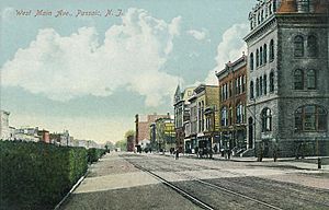
Passaic has several shopping and business areas. Main Avenue and Broadway are two important streets with many shops and restaurants. These businesses reflect the city's diverse population.
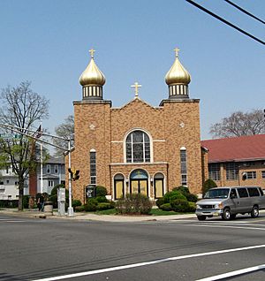
The city has many beautiful churches with interesting architecture. These include St. John's Lutheran Church and First Presbyterian of Passaic.
Passaic Park
The Passaic Park area is known for its large park and unique homes. Many residents in this section are part of Orthodox Jewish communities. This community is growing quickly, with over 1,300 families. It has many yeshivas (religious schools) and kosher food stores.
Passaic Park also has several apartment buildings. Carlton Tower is the tallest building in the city, with 21 floors.
Climate in Passaic
Passaic has a humid subtropical climate. This means it has hot, humid summers. Winters are generally mild to cool.
Population and People
Passaic is a diverse city. In 2010, about 71% of the population was Hispanic or Latino. Many residents speak Spanish at home. Other languages spoken include Gujarati and Polish.
The city has a large and growing Orthodox Jewish community. This community has many schools and shops that serve its needs. Many people born outside the United States live in Passaic. A large number of these residents come from Latin American countries like Mexico and the Dominican Republic.
Economy
Passaic is part of an Urban Enterprise Zone (UEZ). This program helps encourage businesses to create jobs in the city. Shoppers in these zones can pay a lower sales tax rate. Passaic joined the UEZ program in 1994. The program helps bring money back into the local area.
City Government
Passaic is run by a mayor and a city council. The mayor is elected by the people for a four-year term. The city council has seven members, who also serve four-year terms. Elections for these positions are held in May and are non-partisan, meaning candidates do not run as members of political parties.
The current mayor of Passaic is Hector Carlos Lora. He was first appointed in 2016 and then elected to a full term in 2017.
Passaic is part of the 9th Congressional District for national elections. For state elections, it is in New Jersey's 36th legislative district. The city generally votes for Democratic candidates in presidential elections.
Education in Passaic
Public Schools
The Passaic City School District serves students from pre-kindergarten through 12th grade. The district has 17 schools. These schools include:
- Vincent Capuana School No. 15
- Thomas Jefferson School No. 1
- Mario J. Drago School No. 3
- Martin Luther King Jr. School No. 6
- William B. Cruise Veterans Memorial School No. 11
- Passaic Academy for Science and Engineering
- Passaic Preparatory Academy
- Passaic High School
Passaic County Community College opened a campus in Passaic in 2008. This campus helps local students get a college education. It also has a nursing program to help with the shortage of nurses.
Private and Religious Schools
Passaic has several private and religious schools:
- St. Nicholas Ukrainian Catholic School (elementary)
- Collegiate School (private, pre-kindergarten to 12th grade)
- Yeshiva Gedola of Passaic (Talmudic learning for men)
- Yeshiva Ketana and YBH of Passaic (Orthodox K-8 elementary schools)
- Noble Leadership Academy (Islamic school, pre-kindergarten to 12th grade)
Emergency Services
Passaic has its own police, fire, and ambulance services.
Police
The city's police department is led by Deputy Chief Luis Guzman.
Fire Department
The Passaic Fire Department (PFD) has over 100 firefighters. It was started in 1869 and became a paid department in 1909. The PFD has two fire stations with engines and ladder trucks. They also have special vehicles for foam, hazardous materials, and water rescues.
Ambulance Services
Ambulance service in Passaic is provided by MONOC, a non-profit group. There is also a volunteer ambulance service called Hatzolah of Passaic/Clifton EMS. They mainly help in the Passaic Park area and parts of Clifton.
Office of Emergency Management
The Office of Emergency Management (OEM) helps coordinate how the city responds to emergencies. This includes big storms and other disasters. The OEM works with police, fire, ambulance, and public works teams. They also manage traffic during large city events like festivals.
Transportation
Roads and Highways
Passaic has over 70 miles of roads. The main highway serving the city is Route 21. Other major highways like New Jersey Route 3, the Garden State Parkway, and I-80 are nearby. Six bridges cross the Passaic River within the city.
Public Transportation
Local buses are provided by NJ Transit and Community Coach. These buses connect Passaic to nearby cities like Paterson, Newark, and Clifton. Some bus routes also go to the Port Authority Bus Terminal in New York City.
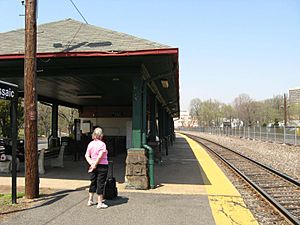
NJ Transit's Passaic rail station offers train service. You can take a train south to Hoboken Terminal or connect to New York Penn Station in New York City. Northbound trains go to places like Paterson and Ridgewood.
Films Shot in Passaic
- 2009: The TV series Mercy was filmed at the old St. Mary's Hospital.
- 2006: Be Kind Rewind was directed by Michel Gondry.
Notable people
See also
 In Spanish: Passaic (Nueva Jersey) para niños
 | Jewel Prestage |
 | Ella Baker |
 | Fannie Lou Hamer |


