Passaic County, New Jersey facts for kids
Quick facts for kids
Passaic County
|
|||
|---|---|---|---|
|
|||
|
|||
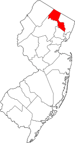
Location within the U.S. state of New Jersey
|
|||
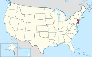 New Jersey's location within the U.S. |
|||
| Country | |||
| State | |||
| Founded | February 7, 1837 | ||
| Named for | "Pasaeck" (Lenape word meaning "valley") | ||
| Seat | Paterson | ||
| Largest municipality | Paterson (population) West Milford (area) |
||
| Area | |||
| • Total | 198.39 sq mi (513.8 km2) | ||
| • Land | 186.01 sq mi (481.8 km2) | ||
| • Water | 12.38 sq mi (32.1 km2) 6.2% | ||
| Population
(2020)
|
|||
| • Total | 524,118 | ||
| • Estimate
(2024)
|
526,597 |
||
| • Density | 2,641.86/sq mi (1,020.027/km2) | ||
| Time zone | UTC−5 (Eastern) | ||
| • Summer (DST) | UTC−4 (EDT) | ||
| Congressional districts | 5th, 9th, 11th | ||
Passaic County is a county in the state of New Jersey, USA. It is part of the larger New York metropolitan area. In 2020, it was the eighth-most-populated county in New Jersey. The county had 524,118 residents, which was its highest population count ever. This number grew by 22,892 people since the 2010 census. Passaic County is located in the northern part of New Jersey.
The city of Paterson is the most populated place in Passaic County. It is also the county seat, which means it's where the county government is located. Paterson had 159,732 residents in 2020, making up over 30% of the county's population. On the other hand, West Milford covers the largest area, taking up more than 40% of the county's total land.
Contents
- Discover Passaic County
- A Look at Its Past
- Exploring Passaic's Nature and Weather
- Who Lives in Passaic County?
- How Passaic County is Governed
- Connecting Passaic: Roads and Transit
- Passaic County's Political Landscape
- Towns and Communities of Passaic County
- Passaic County's Economy
- Learning in Passaic County
- Media in Passaic County
- Fun Places to Visit in Passaic County
- See also
Discover Passaic County
A Look at Its Past
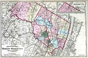
Passaic County was officially created on February 7, 1837. It was formed using parts of Bergen and Essex counties.
How Passaic Got Its Name
The name "Passaic" comes from an old Lenape word, "Pasaeck." This word means "valley," which describes some of the county's beautiful landscape.
Exploring Passaic's Nature and Weather
Passaic County's Climate
Passaic County experiences a humid continental climate. This means it has warm summers and cold winters. In Paterson, the county seat, average temperatures in January are around 19°F (‑7°C). In July, they can reach about 86°F (30°C). The county also gets a good amount of rain, with September usually being the wettest month.
Mountains, Rivers, and Lakes
Passaic County is located in northern New Jersey. Its landscape includes some hilly areas and many lakes. The county stretches about 30 miles (48 km) by 20 miles (32 km) wide. Major roads like Interstate 287 and Interstate 80 cross through the region. The Garden State Parkway also runs through the southern part.
The Passaic River flows through the county. It winds past Totowa into Paterson, then turns south towards Passaic. The highest point in Passaic County is on Bearfort Ridge in West Milford, reaching about 1,480 feet (451 meters) above sea level. The lowest point is about 20 feet (6 meters) along the Passaic River in Clifton. The southeastern part of the county is flatter or has gentle hills. The northwestern part is more rugged and mountainous.
According to the U.S. Census Bureau, Passaic County covers a total area of 198.39 square miles (513.8 km²). About 186.01 square miles (481.8 km²) is land, and 12.38 square miles (32.1 km²) is water.
| Weather chart for Paterson, New Jersey | |||||||||||||||||||||||||||||||||||||||||||||||
|---|---|---|---|---|---|---|---|---|---|---|---|---|---|---|---|---|---|---|---|---|---|---|---|---|---|---|---|---|---|---|---|---|---|---|---|---|---|---|---|---|---|---|---|---|---|---|---|
| J | F | M | A | M | J | J | A | S | O | N | D | ||||||||||||||||||||||||||||||||||||
|
3.5
38
19
|
2.8
41
22
|
4.1
50
30
|
4.3
62
40
|
4.2
72
50
|
4.4
81
60
|
4.5
86
65
|
3.8
84
63
|
4.7
76
55
|
4.3
64
42
|
4
54
34
|
4
43
25
|
||||||||||||||||||||||||||||||||||||
| temperatures in °F precipitation totals in inches source: The Weather Channel |
|||||||||||||||||||||||||||||||||||||||||||||||
|
Metric conversion
|
|||||||||||||||||||||||||||||||||||||||||||||||
Who Lives in Passaic County?
Population Snapshot
In 2020, Passaic County had 524,118 people living in 177,075 households. The population density was about 2,818 people per square mile (1,088 per km²).
The county's population is very diverse. In 2020, about 43.8% of residents identified as White. About 11.0% were Black or African American, and 5.9% were Asian. A large portion, 42.7%, identified as Hispanic or Latino (who can be of any race). About 23.0% of residents were under 18 years old, and 14.9% were 65 or older. The median household income in 2020 was $77,040. About 13.4% of the population lived below the poverty line.
How Passaic County is Governed
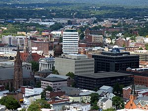
Passaic County is governed by a Board of County Commissioners. This board handles both the executive and legislative duties for the county. Seven Commissioners are elected by the public for three-year terms. They are chosen in a staggered way, meaning not all terms end at the same time. The Commissioners choose a Director and Deputy Director from among themselves each January.
The county government works through six main committees. These committees cover areas like administration, finance, health, public works, law, and human services. The Commissioners also appoint people to various departments and boards to help run the county.
As of 2025, the Passaic County Commissioners included:
| Commissioner | Party, Residence, Term End |
|---|---|
| Director John W. Bartlett | D, Wayne, 2027 |
| Deputy Director Cassandra "Sandi" Lazzara | D, Little Falls, 2027 |
| Orlando Cruz | D, Paterson, 2026 |
| Terry Duffy | D, West Milford, 2025 |
| Rodney DeVore | D, Paterson, 2027 |
| Bruce James | D, Clifton, 2026 |
| Pasquale "Pat" Lepore | D, Woodland Park, 2025 |
Republicans have not won a countywide election since 2021. In March 2023, Orlando Cruz joined the commission, replacing T.J. Best.
County Leaders and Their Roles
Other important elected officials in Passaic County include:
| County Office | Party, Residence, Term End |
|---|---|
| County Clerk Danielle Ireland-Imhof | D, Hawthorne, 2028 |
| Sheriff Thomas Adamo | D, Wayne, 2027 |
| Surrogate Zoila S. Cassanova | D, Wayne, 2026 |
The Passaic County Prosecutor is Camelia M. Valdes. She was appointed in 2009 and reappointed in 2015. The county's main court is the New Jersey Superior Court, located in Paterson.
Local Law Enforcement
The Passaic County Sheriff's Office helps keep the county safe. They provide police patrols, detective services, and manage the Passaic County Jail. They also secure county buildings like the courthouse. Each town in Passaic County also has its own local police department. These local departments usually handle law enforcement within their town's borders.
Connecting Passaic: Roads and Transit
Getting Around by Public Transport
Passaic County has several NJ Transit train stations. These include Montclair State University, Little Falls, and Wayne/Route 23 on the Montclair-Boonton Line. The "Main Line" also runs through the county. It has stations like Hawthorne, Paterson, and Clifton.
Major Roads and Highways
Many important roads cross through Passaic County. These include County Route 502, 504, 509, 511, and 513. State routes like Route 19, Route 20, Route 21, and Route 23 are also important. U.S. Route 202 and U.S. Route 46 also pass through.
For larger travel, Interstate 80 runs east-west through the county. Interstate 287 goes through the mountainous areas. The Garden State Parkway also crosses through Clifton.
Passaic County's Political Landscape
Passaic County used to be a "swing county," meaning it often voted for the winning presidential candidate. From 1920 to 1992, it voted for the national winner in almost every election. After 1996, the county generally supported Democratic candidates.
However, in recent years, there have been some shifts. In the 2024 presidential election, Donald Trump won the county, making him the first Republican to do so since 1992. This included wins in cities like Passaic and Clifton. In the 2025 gubernatorial election, Passaic County voted for the Democratic candidate, Mikie Sherrill.
As of August 1, 2020, there were 318,029 registered voters in Passaic County. About 40.3% were registered as Democrats. About 20.3% were registered as Republicans. Another 37.8% were registered as Unaffiliated, meaning they didn't choose a specific party.
New Jersey's Fifth Congressional District is represented by Josh Gottheimer (D, Wyckoff). New Jersey's Ninth Congressional District is represented by Bill Pascrell (D, Paterson). New Jersey's Eleventh Congressional District is represented by Rodney Frelinghuysen (R, Harding Township).
Towns and Communities of Passaic County
Passaic County has 16 municipalities, which are like towns or cities. Some of these municipalities also have smaller, unincorporated communities within them. These are often called census-designated places (CDPs) for counting purposes.
| Municipality | Mun. type |
Pop. | Housing units |
Total area |
Water area |
Land Area |
Pop. density |
Housing density |
School district | Unincorporated communities / notes |
|---|---|---|---|---|---|---|---|---|---|---|
| Bloomingdale | borough | 7,777 | 3,089 | 9.17 | 0.45 | 8.71 | 878.6 | 354.5 | Butler (9–12) (S/R) Bloomingdale (K–8) |
|
| Clifton | city | 90,296 | 31,946 | 11.40 | 0.14 | 11.26 | 7,472.0 | 2,837.1 | Clifton | |
| Haledon | borough | 9,052 | 2,932 | 1.16 | 0.00 | 1.15 | 7,203.9 | 2,539.3 | Manchester (9–12) Haledon (PK–8) |
|
| Hawthorne | borough | 19,637 | 7,756 | 3.36 | 0.03 | 3.33 | 5,635.3 | 2,326.0 | Hawthorne | |
| Little Falls | township | 13,360 | 4,925 | 2.81 | 0.07 | 2.74 | 5,276.2 | 1,800.5 | Passaic Valley (9–12) Little Falls (K–8) |
Great Notch CDP (3,289) Singac CDP (3,602) |
| North Haledon | borough | 8,927 | 3,213 | 3.50 | 0.04 | 3.45 | 2,436.8 | 930.2 | Manchester (9–12) North Haledon (PK–8) |
|
| Passaic | city | 70,537 | 20,432 | 3.24 | 0.10 | 3.15 | 22,179.6 | 6,494.2 | Passaic | |
| Paterson | city | 159,732 | 47,946 | 8.70 | 0.28 | 8.43 | 18,948.0 | 5,688.7 | Paterson | |
| Pompton Lakes | borough | 11,127 | 4,341 | 3.19 | 0.28 | 2.91 | 3,809.1 | 1,490.1 | Pompton Lakes | |
| Prospect Park | borough | 6,372 | 1,931 | 0.48 | 0.00 | 0.48 | 12,347.2 | 4,065.2 | Manchester (9–12) Prospect Park (PK–8) |
|
| Ringwood | borough | 11,735 | 4,331 | 28.17 | 2.96 | 25.21 | 485.0 | 171.8 | Lakeland (9–12) Ringwood (K–8) |
|
| Totowa | borough | 11,065 | 3,918 | 4.07 | 0.07 | 3.99 | 2,704.9 | 980.9 | Passaic Valley (9–12) Totowa (PK–8) |
|
| Wanaque | borough | 11,317 | 4,184 | 9.25 | 1.26 | 7.99 | 1,391.2 | 523.7 | Lakeland (9–12) Wanaque (PK–8) |
Haskell |
| Wayne | township | 54,838 | 19,768 | 25.17 | 1.45 | 23.73 | 2,306.0 | 833.1 | Wayne | Packanack Lake CDP (6,261) Pines Lake CDP (3,033) Preakness CDP (18,487) William Paterson University of New Jersey CDP (1,417) |
| West Milford | township | 24,862 | 10,419 | 80.32 | 5.23 | 75.09 | 344.3 | 138.8 | West Milford | Cooper Hewitt CDP (1,912) Macopin CDP (2,199) Newfoundland CDP (part; 1,145) Oak Ridge CDP (part; 10,996) Upper Greenwood Lake CDP (part; 3,687) |
| Woodland Park | borough | 13,484 | 4,835 | 3.11 | 0.15 | 2.96 | 3,987.9 | 1,631.4 | Passaic Valley (9–12) Woodland Park (K–8) |
(formerly West Paterson) |
| Passaic County | county | 524,118 | 175,966 | 197.11 | 12.51 | 184.59 | 2,715.3 | 953.3 |
Historic Municipalities
- West Paterson Borough was renamed Woodland Park in 2009.
Other Communities
- Montclair State University CDP (part; 2,180)
Passaic County's Economy
In 2021, the total value of goods and services produced in Passaic County was $20.5 billion. This ranked it 13th in New Jersey and showed a 4.8% increase from the year before.
Businesses and Jobs
Several companies have had their main offices in Passaic County:
- Toys "R" Us' former U.S. headquarters was in Wayne.
- Valley National Bank's main office is in Wayne.
- Linens ‘n Things's headquarters was in Clifton. It employed 17,500 people before closing in 2009.
- JVC has its U.S. office in Wayne. It employs about 19,040 people.
Learning in Passaic County
Passaic County offers several educational opportunities:
- Passaic County Community College was founded in 1971. It serves students from Passaic County at campuses in Paterson, Wanaque, and Wayne.
- William Paterson University is a public university in Wayne. It was established in 1855.
- Montclair State University is a public university founded in 1908. It is located in Montclair, with parts extending into Little Falls and Clifton.
- Passaic County Technical Institute opened in 1975. It provides vocational schooling for students in grades 9–12.
Media in Passaic County
Passaic County receives television and radio broadcasts from New York City. It also has public television from New Jersey Network.
- The West Milford Messenger is a community newspaper for the West Milford area.
- The Record, Suburban Trends and AIM West Milford are weekly community newspapers.
Fun Places to Visit in Passaic County
- Dey Mansion, in Wayne, was used by George Washington as his headquarters during the American Revolutionary War.
- Garret Mountain Reservation in Paterson and Woodland Park is a National Natural Landmark. It covers 568 acres (2.3 km²).
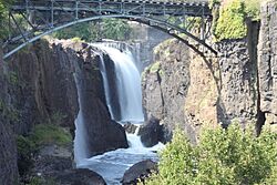
- Paterson Great Falls National Historical Park in Paterson features a large waterfall.
- High Mountain Park Preserve in Wayne offers natural beauty.
- Hinchliffe Stadium in Paterson is a historic stadium with 7,000 seats. It was once a venue for Negro league baseball. Since May 2023, it has been home to the New Jersey Jackals baseball team.
- Lambert Castle in Paterson is a beautiful historic building.
- Long Pond Ironworks State Park in West Milford preserves an old iron-making site.
- Paterson Museum, located in Paterson, tells the story of the city's industrial past.
- Ringwood State Park in Ringwood offers outdoor activities.
- Skylands, the New Jersey State Botanical Garden in Ringwood, has beautiful formal gardens. These gardens are open to the public all year. They include a Lilac Garden, Magnolia Walk, and a Wild Flower Garden.
- Yogi Berra Stadium in Little Falls is on the campus of Montclair State University. It was home to the New Jersey Jackals until 2022 and is still used by Montclair State's baseball team. The stadium can hold up to 5,000 people.
See also
 In Spanish: Condado de Passaic para niños
 | James B. Knighten |
 | Azellia White |
 | Willa Brown |


