North Haledon, New Jersey facts for kids
Quick facts for kids
North Haledon, New Jersey
|
||
|---|---|---|
|
Borough
|
||
|
||
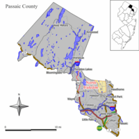
Map of North Haledon in Passaic County. Inset: Location of Passaic County highlighted in the State of New Jersey.
|
||
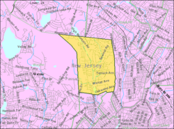
Census Bureau map of North Haledon, New Jersey
|
||
| Country | ||
| State | ||
| County | ||
| Incorporated | March 20, 1901 | |
| Government | ||
| • Type | Borough | |
| • Body | Borough Council | |
| Area | ||
| • Total | 3.53 sq mi (9.14 km2) | |
| • Land | 3.46 sq mi (8.97 km2) | |
| • Water | 0.06 sq mi (0.17 km2) 1.81% | |
| Area rank | 313th of 565 in state 9th of 16 in county |
|
| Elevation | 302 ft (92 m) | |
| Population
(2020)
|
||
| • Total | 8,927 | |
| • Estimate
(2023)
|
8,633 | |
| • Rank | 265th of 565 in state 14th of 16 in county |
|
| • Density | 2,577.1/sq mi (995.0/km2) | |
| • Density rank | 245th of 565 in state 11th of 16 in county |
|
| Time zone | UTC−05:00 (Eastern (EST)) | |
| • Summer (DST) | UTC−04:00 (Eastern (EDT)) | |
| ZIP Codes |
07508, 07538
|
|
| Area code(s) | 973 | |
| FIPS code | 3403153040 | |
| GNIS feature ID | 0885325 | |
| Website | ||
North Haledon (pronounced North HAIL-don) is a small town called a borough in Passaic County, New Jersey. It's located in the U.S. state of New Jersey.
In 2020, about 8,927 people lived here. This was a bit more than in 2010. North Haledon became a borough on March 20, 1901. It was created from parts of an older area called Manchester Township.
Contents
Exploring North Haledon's Location
North Haledon covers about 3.53 square miles (9.14 square kilometers). Most of this area is land, with a small part being water.
The borough shares its borders with several other towns. In Passaic County, it borders Haledon, Hawthorne, Prospect Park, and Wayne. It also borders Franklin Lakes and Wyckoff in Bergen County.
Who Lives in North Haledon?
| Historical population | |||
|---|---|---|---|
| Census | Pop. | %± | |
| 1910 | 749 | — | |
| 1920 | 887 | 18.4% | |
| 1930 | 2,157 | 143.2% | |
| 1940 | 2,761 | 28.0% | |
| 1950 | 3,550 | 28.6% | |
| 1960 | 6,026 | 69.7% | |
| 1970 | 7,614 | 26.4% | |
| 1980 | 8,177 | 7.4% | |
| 1990 | 7,987 | −2.3% | |
| 2000 | 7,920 | −0.8% | |
| 2010 | 8,417 | 6.3% | |
| 2020 | 8,927 | 6.1% | |
| 2023 (est.) | 8,633 | 2.6% | |
| Population sources: 1910–1920 1910 1910–1930 1940–2000 2000 2010 2020 |
|||
North Haledon's Population in 2010
In 2010, there were 8,417 people living in North Haledon. These people lived in 3,123 homes. About 2,386 of these homes were families.
Most of the people (91.53%) were White. There were also people who identified as Black or African American (1.76%), Asian (3.78%), and other groups. About 7.46% of the population was Hispanic or Latino.
In terms of age, about 20.4% of the people were under 18. About 20.3% were 65 or older. The average age in North Haledon was 45 years old.
The average income for a household was about $103,562 in 2010. For families, it was about $107,623.
Learning in North Haledon: Schools and Education
The North Haledon School District provides public education for students from kindergarten through eighth grade. There are two schools in the district.
- Memorial School: This school teaches students from kindergarten to 4th grade.
- High Mountain School: This school is for students in 5th to 8th grade.
High School Education
For ninth through twelfth grades, students from North Haledon attend Manchester Regional High School. This high school is located in Haledon. Students from Haledon and Prospect Park also go to this school.
The school district allows some students from outside the area to attend without paying tuition. This is part of a program called the Interdistrict Public School Choice Program.
In 2003, North Haledon residents voted to send their high school students to a different school, Midland Park High School. However, in 2004, the New Jersey Supreme Court decided that North Haledon should stay with Manchester Regional High School. The court felt that leaving would change the mix of students at the high school.
Private School Options
Eastern Christian High School is a private school founded in 1892. It serves over 700 students. This school has four different buildings for students from preschool all the way through 12th grade.
Getting Around North Haledon: Transportation
North Haledon has about 36.97 miles of roads. Most of these roads are maintained by the town itself.
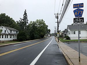
No major highways like Interstate, U.S., or state routes go directly through North Haledon. The most important roads are smaller county routes, such as County Route 677, also known as High Mountain Road.
For public transportation, NJ Transit offers local bus service on the 703 route.
Famous People from North Haledon
Many interesting people have lived in or are connected to North Haledon. Here are a few:
- Gérard Debaets (1899–1959), a professional racing cyclist from Belgium.
- John A. Ferraro (1946–2010), an actor, academic, and director for stage and television.
- Joseph J. Helble, an academic who became the President of Lehigh University in 2021.
- Glenn Mercer, a singer and guitarist for the rock band The Feelies.
- Nellie Pou (born 1956), a politician who represents the 35th Legislative District in the New Jersey General Assembly.
See also
 In Spanish: North Haledon para niños
 | Emma Amos |
 | Edward Mitchell Bannister |
 | Larry D. Alexander |
 | Ernie Barnes |


