
Mercer County, New Jersey facts for kids
Quick facts for kids
Mercer County
|
|||
|---|---|---|---|

The New Jersey State House and its golden dome in Trenton in 2006
|
|||
|
|||
| Nickname(s):
The Capital County
|
|||

Location within the U.S. state of New Jersey
|
|||
 New Jersey's location within the U.S. |
|||
| Country | |||
| State | |||
| Founded | 1838 | ||
| Named for | Hugh Mercer | ||
| Seat | Trenton | ||
| Largest municipality | Hamilton Township (population) Hopewell Township (area) |
||
| Area | |||
| • Total | 228.86 sq mi (592.7 km2) | ||
| • Land | 224.44 sq mi (581.3 km2) | ||
| • Water | 4.42 sq mi (11.4 km2) 1.9% | ||
| Population
(2020)
|
|||
| • Total | 387,340 | ||
| • Estimate
(2023)
|
381,671 |
||
| • Density | 1,692.48/sq mi (653.469/km2) | ||
| Time zone | UTC−5 (Eastern) | ||
| • Summer (DST) | UTC−4 (EDT) | ||
| Congressional districts | 3rd, 12th | ||


Mercer County is a county located in the state of New Jersey. Its main city, called the county seat, is Trenton. Trenton is also the capital city of New Jersey, which is why Mercer County is known as The Capital County. The county is part of the Central Jersey region.
In 2020, Mercer County was the 12th most populated county in New Jersey. It had 387,340 people living there. This was the highest number of people ever counted in the county! Hamilton Township had the most residents, while Hopewell Township was the largest in terms of land area.
Mercer County was created on February 22, 1838. It was formed from parts of other counties like Burlington, Hunterdon, and Middlesex.
Trenton–Mercer Airport in Ewing Township is an airport that serves the county. Princeton is a town in Mercer County. It is home to Princeton University, a very famous research university. Mercer County has 12 towns and cities, which is one of the fewest in New Jersey.

.jpg)
Contents
Why is it Called Mercer County?
Mercer County was named after General Hugh Mercer. He was a general in the Continental Army during the American Revolutionary War. He sadly died from injuries he got at the Battle of Princeton on January 3, 1777.
General Mercer was a Scottish doctor who came to America. He worked closely with George Washington during the American Revolution. In January 1777, Washington's army was heading to Princeton. General Mercer was leading a group of 350 soldiers when they met British troops. A battle started, and Mercer's horse was shot. He was surrounded by British soldiers who thought he was George Washington. They told him to give up. Even though he was outnumbered, he fought back. He was badly hurt and left for dead.
A famous story says that Mercer, even with a bayonet in him, didn't want to leave his soldiers. He rested against a white oak tree while his men kept fighting. This tree, called the Mercer Oak, was very old and stood for 250 years. It even appears on the county's official seal! The tree fell in 2000.
Mercer County's History
Mercer County has a rich history, especially from the American Revolutionary War. On the night of December 25–26, 1776, General George Washington led American forces across the Delaware River. They attacked the Hessian soldiers in Trenton on December 26. After that battle, Washington went back to Pennsylvania.
He crossed the river again for a surprise attack on January 2, 1777, at the Second Battle of Trenton. The next day, on January 3, they fought the Battle of Princeton. These successful attacks made the American colonists feel much more hopeful about winning their independence.
Mercer County is also famous for a fictional event! In 1938, Orson Welles created a famous radio play called The War of the Worlds. In the story, aliens first "landed" in what is now West Windsor Township. There is a monument in Grover's Mill park to remember this fictional landing.
Sadly, 27 people from Mercer County died in the terrorist attacks on September 11, 2001. A large steel beam from the World Trade Center, weighing one ton, was given to the county in 2011. It is now on display at Mercer County Park as a memorial.
Geography and Climate
Mercer County covers about 228.86 square miles. Most of this is land (98.1%), and a small part is water (1.9%).
The county is mostly flat and low. There are a few hills closer to the Delaware River. The highest point is Baldpate Mountain, near Pennington, which is about 480 feet above sea level. The lowest point is at sea level along the Delaware River.
Mercer County's Weather
Most of Mercer County has a hot-summer humid continental climate. This means it has warm, humid summers and cold winters. The southern part of the county, including Trenton, has a humid subtropical climate. This means it has hot, humid summers and mild winters.
| Climate data for Trenton, New Jersey (Trenton–Mercer Airport) 1991–2020 normals, extremes 1865–present | |||||||||||||
|---|---|---|---|---|---|---|---|---|---|---|---|---|---|
| Month | Jan | Feb | Mar | Apr | May | Jun | Jul | Aug | Sep | Oct | Nov | Dec | Year |
| Record high °F (°C) | 73 (23) |
78 (26) |
87 (31) |
93 (34) |
99 (37) |
100 (38) |
106 (41) |
105 (41) |
101 (38) |
94 (34) |
83 (28) |
76 (24) |
106 (41) |
| Mean maximum °F (°C) | 62 (17) |
62 (17) |
73 (23) |
84 (29) |
88 (31) |
93 (34) |
96 (36) |
94 (34) |
90 (32) |
82 (28) |
72 (22) |
65 (18) |
97 (36) |
| Mean daily maximum °F (°C) | 39.7 (4.3) |
42.8 (6.0) |
50.8 (10.4) |
62.9 (17.2) |
72.4 (22.4) |
81.0 (27.2) |
86.0 (30.0) |
84.0 (28.9) |
77.1 (25.1) |
65.5 (18.6) |
54.5 (12.5) |
44.4 (6.9) |
63.4 (17.4) |
| Daily mean °F (°C) | 32.0 (0.0) |
34.3 (1.3) |
41.7 (5.4) |
52.5 (11.4) |
62.0 (16.7) |
71.0 (21.7) |
76.3 (24.6) |
74.4 (23.6) |
67.4 (19.7) |
55.7 (13.2) |
45.4 (7.4) |
36.8 (2.7) |
54.1 (12.3) |
| Mean daily minimum °F (°C) | 24.3 (−4.3) |
25.9 (−3.4) |
32.7 (0.4) |
42.1 (5.6) |
51.6 (10.9) |
60.9 (16.1) |
66.6 (19.2) |
64.8 (18.2) |
57.7 (14.3) |
45.9 (7.7) |
36.3 (2.4) |
29.3 (−1.5) |
44.8 (7.1) |
| Mean minimum °F (°C) | 8 (−13) |
11 (−12) |
19 (−7) |
29 (−2) |
38 (3) |
49 (9) |
58 (14) |
55 (13) |
45 (7) |
32 (0) |
23 (−5) |
16 (−9) |
6 (−14) |
| Record low °F (°C) | −16 (−27) |
−14 (−26) |
0 (−18) |
11 (−12) |
31 (−1) |
39 (4) |
46 (8) |
39 (4) |
34 (1) |
21 (−6) |
9 (−13) |
−8 (−22) |
−16 (−27) |
| Average precipitation inches (mm) | 3.29 (84) |
2.63 (67) |
3.97 (101) |
3.63 (92) |
3.99 (101) |
4.25 (108) |
4.39 (112) |
4.22 (107) |
4.09 (104) |
3.79 (96) |
3.18 (81) |
4.04 (103) |
45.47 (1,155) |
| Average precipitation days (≥ 0.01 in) | 10.1 | 10.1 | 11.0 | 11.5 | 12.0 | 11.9 | 10.8 | 10.0 | 8.6 | 10.0 | 8.5 | 11.0 | 125.5 |
| Average relative humidity (%) | 65.4 | 61.7 | 58.0 | 57.0 | 62.1 | 66.1 | 66.2 | 68.8 | 69.8 | 68.8 | 66.9 | 66.5 | 64.8 |
| Average dew point °F (°C) | 21.7 (−5.7) |
22.8 (−5.1) |
28.1 (−2.2) |
37.7 (3.2) |
48.7 (9.3) |
59.4 (15.2) |
63.9 (17.7) |
63.5 (17.5) |
57.0 (13.9) |
45.6 (7.6) |
35.9 (2.2) |
26.5 (−3.1) |
42.7 (5.9) |
| Mean monthly sunshine hours | 163.1 | 169.7 | 207.4 | 227.2 | 248.1 | 262.8 | 269.2 | 252.5 | 215.0 | 201.5 | 149.3 | 140.1 | 2,505.9 |
| Percent possible sunshine | 54 | 57 | 56 | 57 | 56 | 58 | 59 | 59 | 57 | 58 | 50 | 48 | 56 |
| Source 1: NOAA (sun 1961–1981) | |||||||||||||
| Source 2: PRISM Climate Group (humidity and dew point) | |||||||||||||
| Climate data for Lawrence, Mercer County (40.2833, -74.7015), Elevation 62 ft (19 m), 1991–2020 normals, extremes 1981–2022 | |||||||||||||
|---|---|---|---|---|---|---|---|---|---|---|---|---|---|
| Month | Jan | Feb | Mar | Apr | May | Jun | Jul | Aug | Sep | Oct | Nov | Dec | Year |
| Record high °F (°C) | 71.6 (22.0) |
77.6 (25.3) |
88.2 (31.2) |
17.9 (−7.8) |
95.6 (35.3) |
98.3 (36.8) |
102.9 (39.4) |
100.8 (38.2) |
97.6 (36.4) |
93.8 (34.3) |
80.8 (27.1) |
75.4 (24.1) |
102.9 (39.4) |
| Mean daily maximum °F (°C) | 40.4 (4.7) |
43.0 (6.1) |
50.8 (10.4) |
63.2 (17.3) |
72.7 (22.6) |
81.9 (27.7) |
86.5 (30.3) |
84.8 (29.3) |
78.2 (25.7) |
66.3 (19.1) |
55.5 (13.1) |
45.4 (7.4) |
64.2 (17.9) |
| Mean daily minimum °F (°C) | 23.7 (−4.6) |
25.2 (−3.8) |
32.1 (0.1) |
42.0 (5.6) |
51.6 (10.9) |
60.7 (15.9) |
66.1 (18.9) |
64.3 (17.9) |
57.3 (14.1) |
45.6 (7.6) |
35.8 (2.1) |
28.9 (−1.7) |
44.5 (6.9) |
| Record low °F (°C) | −9.9 (−23.3) |
−2.0 (−18.9) |
4.9 (−15.1) |
— | 32.6 (0.3) |
41.8 (5.4) |
48.0 (8.9) |
42.2 (5.7) |
36.4 (2.4) |
24.7 (−4.1) |
10.8 (−11.8) |
0.0 (−17.8) |
−9.9 (−23.3) |
| Average precipitation inches (mm) | 3.56 (90) |
2.76 (70) |
4.26 (108) |
3.68 (93) |
4.04 (103) |
4.48 (114) |
4.94 (125) |
4.44 (113) |
4.18 (106) |
4.12 (105) |
3.32 (84) |
4.37 (111) |
48.15 (1,223) |
| Average dew point °F (°C) | 21.8 (−5.7) |
22.5 (−5.3) |
28.0 (−2.2) |
37.5 (3.1) |
49.2 (9.6) |
59.4 (15.2) |
64.4 (18.0) |
63.6 (17.6) |
57.7 (14.3) |
46.1 (7.8) |
35.1 (1.7) |
27.5 (−2.5) |
42.8 (6.0) |
| Source: PRISM | |||||||||||||
What Plants Grow Here?
Most of Mercer County would naturally have a lot of Oak trees. It would look like an Eastern Hardwood Forest. Some areas might also have a mix of oak and pine trees.
Mercer County's Population
| Historical population | |||
|---|---|---|---|
| Census | Pop. | %± | |
| 1840 | 21,502 | — | |
| 1850 | 27,992 | 30.2% | |
| 1860 | 37,419 | 33.7% | |
| 1870 | 46,386 | 24.0% | |
| 1880 | 58,061 | 25.2% | |
| 1890 | 79,978 | 37.7% | |
| 1900 | 95,365 | 19.2% | |
| 1910 | 125,657 | 31.8% | |
| 1920 | 159,881 | 27.2% | |
| 1930 | 187,143 | 17.1% | |
| 1940 | 197,318 | 5.4% | |
| 1950 | 229,781 | 16.5% | |
| 1960 | 266,392 | 15.9% | |
| 1970 | 304,116 | 14.2% | |
| 1980 | 307,863 | 1.2% | |
| 1990 | 325,824 | 5.8% | |
| 2000 | 350,761 | 7.7% | |
| 2010 | 366,513 | 4.5% | |
| 2020 | 387,340 | 5.7% | |
| 2023 (est.) | 381,671 | 4.1% | |
| Historical sources: 1790–1990 1970-2010 2010-2019 2020 |
|||
In 2020, Mercer County had 387,340 people. It is the 12th most populated county in New Jersey. The people living here come from many different backgrounds. About 62.3% of the people are white. About 21.6% are Black or African American. About 12.6% are Asian. Also, 19.4% of the people in Mercer County are Hispanic or Latino.
About 21.2% of the population is under 18 years old. About 16.0% are over 65 years old. Slightly more than half of the population (50.8%) are female.
There are over 150,000 homes in Mercer County. About 63.5% of these homes are owned by the people who live in them. The average household has about 2.67 people.
Mercer County's Economy
In 2021, Mercer County's economy produced about $36.0 billion worth of goods and services. This was the seventh highest in New Jersey.
Mercer County is known for having a high income per person. In 2015, the average income per person was $63,720. This was the sixth highest in New Jersey. Trenton being the state capital helps Mercer County's economy a lot. About 9.5% of the people in the county live below the poverty line.
The average household income in Mercer County is $83,306. A high number of people in the county are well-educated. About 89.6% have a high school diploma. About 43.5% have a bachelor's degree or higher. This is one of the highest rates in the state.
Getting Around Mercer County

Roads and Highways
Mercer County has many different types of roads. These include local roads, state roads, U.S. Routes, and Interstates. As of 2010, there were over 1,500 miles of roads in the county.
Here are some of the main roads that go through Mercer County:
- U.S. Route 1 (This road cuts through the middle of the county)
- Route 29
- Route 31
- Interstate 95 (Also known as the New Jersey Turnpike)
- Interstate 195
- U.S. Route 206
- Interstate 295
I-295 goes around the Trenton area. I-195 is an east-west highway that connects Trenton to the Jersey Shore. The New Jersey Turnpike (I-95) goes through the southeast part of the county. It is a major road for traveling to Delaware, Washington, D.C. to the south, and New York City to the north. There are two exits for the Turnpike in Mercer County.
Before 2018, I-95 used to end suddenly in Lawrence Township. This was because a planned highway called the Somerset Freeway was never built. In 2018, that part of I-95 was renamed I-295. This change happened before a new direct connection between I-95 in Pennsylvania and the Pennsylvania Turnpike opened.
Public Transportation
Mercer County has several NJ Transit train stations. These include Trenton, Hamilton, and Princeton Junction. These stations are on the Northeast Corridor Line. There is also a station in Princeton on the Princeton Branch.
SEPTA provides train service from Trenton and West Trenton to Philadelphia. For longer trips, you can take Amtrak trains from the Trenton Transit Center.
The River Line is a light rail service that connects Trenton to Camden. It has three stops within Trenton.
Trenton–Mercer Airport in Ewing Township is the only commercial airport in Mercer County. You can fly to different places across the country from this airport.
Towns and Cities in Mercer County

Mercer County has 12 municipalities (towns and cities). Here is a list of them with some information from the 2010 Census:
Sports and Recreation
Mercer County has many large parks. The biggest one is Mercer County Park. It is even home to the training center for the U.S. Olympic Rowing Team!
Mercer County is also where the Trenton Thunder baseball team plays. They are part of the MLB Draft League. The county also used to have a minor league hockey team called the Trenton Titans.
College Sports Teams
Mercer County is home to several college sports programs. Two of these are NCAA Division I schools. Rider University has teams called the Rider Broncs. They compete in the MAAC. Princeton University's teams are the Princeton Tigers, and they play in the Ivy League.
The College of New Jersey (TCNJ) has teams called the Lions. They compete in NCAA Division III. Mercer County Community College also has sports teams, known as the Mercer Vikings.
Education in Mercer County
Mercer County has many school districts for students from kindergarten to 12th grade.
- K-12 School Districts
- East Windsor Regional School District
- Ewing Public Schools
- Hamilton Township School District
- Hopewell Valley Regional School District
- Lawrence Township Public Schools
- Mercer County Special Services School District
- Princeton Public Schools
- Robbinsville Public School District
- Trenton Public Schools
- West Windsor-Plainsboro Regional School District
- High Schools (Grades 9-12)
- Mercer County Technical Schools
- Special Schools
There is a state-run school called Marie H. Katzenbach School for the Deaf.
Colleges and Universities
Mercer County is home to many colleges and universities. These include:
- Princeton University
- Princeton Theological Seminary
- Institute for Advanced Study
- Rider University
- Westminster Choir College
- The College of New Jersey
- Thomas Edison State University
- Mercer County Community College (a community college run by the county)
Fun Places to Visit
Mercer County has many interesting places to visit:
- Drumthwacket: This is the official home of the Governor of New Jersey, located in Princeton.
- New Jersey State House: This is the main building for New Jersey's government, where state laws are made. It's in Trenton.
- Mercer County Park: A large park in West Windsor with lots of activities.
- Hamilton Veterans Park
- Mercer County Park September 11 Memorial
- Swaminarayan Akshardham: This is the largest Hindu temple outside Asia, located in Robbinsville.
- Assunpink Creek (part)
- Mercer Lake at Mercer County Park
- Griggstown Native Grassland Preserve (part)
- Princeton Battlefield: A historic site from the American Revolutionary War.
- Mercer Oaks Golf Course
- Washington Crossing State Park: A park in Hopewell Township where George Washington crossed the Delaware River.
- Colonial Memorial Park in Trenton
- Lower Trenton Bridge
- Trenton War Memorial
- Trenton Thunder Ballpark
- Grounds for Sculpture: An outdoor sculpture park in Hamilton Township.
Local Wineries
- Hopewell Valley Vineyards
- Working Dog Winery, in East Windsor Township
Images for kids
-
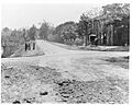
Trenton-New Brunswick Turnpike, the future U.S. Route 1 through Mercer County, 1904
-
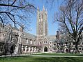
Holder Tower in Princeton University, one of the world's most prominent research universities
See also
 In Spanish: Condado de Mercer (Nueva Jersey) para niños
