
White Horse, New Jersey facts for kids
Quick facts for kids
White Horse, New Jersey
|
|
|---|---|

White Horse Circle
|
|

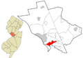
Location in Mercer County and the state of New Jersey
|
|

White Horse, New Jersey
Location in Mercer County, New Jersey

White Horse, New Jersey
Location in New Jersey

White Horse, New Jersey
Location in the United States
|
|
| Country | |
| State | |
| County | Mercer |
| Township | Hamilton |
| Area | |
| • Total | 3.17 sq mi (8.22 km2) |
| • Land | 3.12 sq mi (8.07 km2) |
| • Water | 0.06 sq mi (0.15 km2) 2.05% |
| Elevation | 92 ft (28 m) |
| Population
(2020)
|
|
| • Total | 9,791 |
| • Density | 3,140.15/sq mi (1,212.59/km2) |
| Time zone | UTC−05:00 (Eastern (EST)) |
| • Summer (DST) | UTC−04:00 (Eastern (EDT)) |
| ZIP Code |
08610 (Trenton)
|
| FIPS code | 34-80630 |
| GNIS feature ID | 02390504 |
White Horse is a small community in Hamilton Township, Mercer County, New Jersey, in the United States. It is known as a census-designated place (CDP). This means it is an area that the U.S. Census Bureau defines for gathering population data. In 2020, about 9,791 people lived here.
Contents
What is the History of White Horse?
The name "White Horse" comes from a local story. People say that George Washington rode through this area on a white horse. This happened in 1789. He was traveling from Virginia to New York City for his very first time becoming president.
Where is White Horse Located?
White Horse is in the southern part of Mercer County. Part of its southern edge is along Crosswicks Creek. This creek forms the border with Burlington County. Interstate 195 also makes up some of the southern border.
Interstate 295 goes through the western side of the community. White Horse is next to Yardville on its southeast side. Downtown Trenton is about 4 miles (6.4 km) to the northwest.
U.S. Route 206 runs through the middle of White Horse. It follows Broad Street towards Trenton. In the other direction, US 206 goes south about 3 miles (4.8 km) to Bordentown.
How Big is White Horse?
The U.S. Census Bureau says that White Horse covers a total area of about 3.18 square miles (8.22 square kilometers). Most of this area, about 3.12 square miles (8.07 square kilometers), is land. A small part, about 0.06 square miles (0.15 square kilometers), is water.
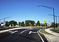
What is the White Horse Circle?
The White Horse Circle is a well-known traffic circle in the southwest part of White Horse. For a long time, it wasn't a true traffic circle. This was because northbound U.S. Route 206 cut right through it.
How the Circle Works
This intersection connects several important roads. These include South Broad Street (US 206 north and Route 524 east). It also connects White Horse-Mercerville Road (Route 533 north) and Bordentown Road (US 206 south).
Before 2018, only Route 533 had a stop sign at the circle. Route 524 and the southern part of Route 206 had traffic signals. There were many yield signs to help cars move safely.
Changes to the Circle
After Interstate 195 and Interstate 295 were built, less traffic went through the circle. These new highways are wider and faster.
Hamilton Township approved a project to change the circle. The changes were finished by 2018. Before the changes, there was about one accident a week at the circle.
The new circle now works like a roundabout. It has two lanes that go around in circles. There are also many arrows to help drivers know where to go. The biggest change is that drivers now have to yield to cars already in the circle. This is different from yielding to cars on the main roads. Since these changes, the number of accidents has gone down.
The White Horse Statue
In 2010, a 10-foot (3.0 m) tall statue of a white horse was put in the circle. This statue remembers the local story about George Washington. It celebrates the idea that he rode a white horse through the area in 1789.
How Many People Live in White Horse?
The population of White Horse has changed over the years. Here's a look at the numbers:
| Historical population | |||
|---|---|---|---|
| Census | Pop. | %± | |
| 1970 | 18,680 | — | |
| 1980 | 10,098 | −45.9% | |
| 1990 | 9,397 | −6.9% | |
| 2000 | 9,373 | −0.3% | |
| 2010 | 9,494 | 1.3% | |
| 2020 | 9,791 | 3.1% | |
| Population sources: 1970-1980 1990-2010 2000 2010 |
|||
What Did the 2010 Census Show?
The 2010 United States census counted 9,494 people living in White Horse. There were 3,875 households and 2,682 families. The area had about 3,088 people per square mile (1,192 per square kilometer).
Most people, about 87.91%, were White. About 5.59% were Black or African American. About 2.19% were Asian. People from Hispanic or Latino backgrounds made up 8.55% of the population.
About 25% of households had children under 18. More than half, 53.9%, were married couples. The average household had 2.45 people. The average family had 2.96 people.
About 19.3% of the people were under 18 years old. About 20% were 65 years or older. The average age in White Horse was 44.6 years.
Images for kids
-
White Horse Circle
-
Location in Mercer County and New Jersey
See also
 In Spanish: White Horse (Nueva Jersey) para niños
