
Burlington County, New Jersey facts for kids
Quick facts for kids
Burlington County
|
|||
|---|---|---|---|
.JPG)
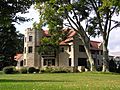
Breidenhart in Moorestown was listed on the National Register of Historic Places in 1977.
|
|||
|
|||

Location within the U.S. state of New Jersey
|
|||
 New Jersey's location within the U.S. |
|||
| Country | |||
| State | |||
| Founded | May 17, 1694 | ||
| Named for | Bridlington, England | ||
| Seat | Mount Holly | ||
| Largest municipality | Evesham Township (population) Washington Township (area) |
||
| Area | |||
| • Total | 820.19 sq mi (2,124.3 km2) | ||
| • Land | 799.29 sq mi (2,070.2 km2) | ||
| • Water | 20.89 sq mi (54.1 km2) 2.5% | ||
| Population
(2020)
|
|||
| • Total | 461,860 | ||
| • Estimate
(2023)
|
469,167 |
||
| • Density | 563.113/sq mi (217.419/km2) | ||
| Time zone | UTC−5 (Eastern) | ||
| • Summer (DST) | UTC−4 (EDT) | ||
| Congressional districts | 1st, 3rd | ||


Burlington County is a large county in the South Jersey area of New Jersey. It's the biggest county in New Jersey when you look at its land area. Its main town, where the county government is located, is Mount Holly.
In 2020, about 461,860 people lived in Burlington County. This was the highest number of people ever recorded for the county! The town with the most people was Evesham Township, and Washington Township was the largest in terms of land size.
Burlington County is located east of the Delaware River. It's also close to Philadelphia, which is one of the biggest cities in the United States. The county is part of a larger area called the Delaware Valley. Even though it's near Philadelphia, the county stretches all the way to the eastern side of New Jersey, close to the Atlantic Ocean.
Contents
What's in a Name?
Records show that Burlington County has been around since 1681. It officially became a county on May 17, 1694. The county was named after Bridlington, a town in England.
A Look Back in Time
Burlington County was once the main government center for the area known as the Province of West Jersey. In 1702, West Jersey joined with East Jersey to form the Province of New Jersey.
When Burlington County first started, it was much bigger! But as more people moved in, parts of it were separated to create new counties. For example, Hunterdon County was formed from its northern part in 1714. Over time, Hunterdon County was also divided, creating three more counties: Morris, Sussex, and Warren.
The county's first main town was Burlington. But as people started to live further inland, away from the Delaware River, a more central location was needed. So, in 1793, the county government moved to Mount Holly.
During the time when factories and industries grew, transportation in Burlington County got much better. This helped farmers sell their crops more easily. Also, as more people moved to towns near the coast, roads across the county were greatly improved.
Land, Water, and Weather

Burlington County covers about 820 square miles. Most of this area, about 799 square miles, is land, and the rest is water.
Most of the county is flat land near the coast and rivers. There are a few small hills, like Apple Pie Hill and Arney's Mount. Arney's Mount is the highest point in the county, standing about 240 feet above sea level. The lowest points are at sea level along the Delaware River and Mullica River.
The county has many rivers, streams, and wet areas. Some important rivers include Rancocas Creek, Assiscunk Creek, Pennsauken Creek, Mullica River, Batsto River, and Wading River.
| Weather chart for Mount Holly, New Jersey | |||||||||||||||||||||||||||||||||||||||||||||||
|---|---|---|---|---|---|---|---|---|---|---|---|---|---|---|---|---|---|---|---|---|---|---|---|---|---|---|---|---|---|---|---|---|---|---|---|---|---|---|---|---|---|---|---|---|---|---|---|
| J | F | M | A | M | J | J | A | S | O | N | D | ||||||||||||||||||||||||||||||||||||
|
3.5
41
22
|
2.9
45
24
|
4.4
53
31
|
4
64
40
|
4
74
49
|
4
82
59
|
4.4
87
64
|
4.9
85
62
|
4.1
78
54
|
3.8
67
43
|
3.7
57
35
|
4
45
27
|
||||||||||||||||||||||||||||||||||||
| temperatures in °F precipitation totals in inches source: The Weather Channel |
|||||||||||||||||||||||||||||||||||||||||||||||
|
Metric conversion
|
|||||||||||||||||||||||||||||||||||||||||||||||
In Mount Holly, the average temperature in January is about 22°F, and in July, it's about 87°F. The county has a humid subtropical climate, which means it has cool to cold winters and hot summers.
Severe thunderstorms are common in the warmer months. Snow usually falls in winter, with about 18 to 22 inches on average. The nearby Atlantic Ocean helps keep the county's climate mild, and it rains often throughout the year.
A special weather effect happens in the Pine Barrens, a large forest in the southern and eastern parts of the county. On clear, dry nights, these sandy areas can be 10 to 15 degrees Fahrenheit colder than nearby places. This is because sandy soil loses heat faster than other types of ground.
People of Burlington County
| Historical population | |||
|---|---|---|---|
| Census | Pop. | %± | |
| 1790 | 18,095 | — | |
| 1800 | 21,521 | 18.9% | |
| 1810 | 24,979 | 16.1% | |
| 1820 | 28,822 | 15.4% | |
| 1830 | 31,107 | 7.9% | |
| 1840 | 32,831 | 5.5% | |
| 1850 | 43,203 | 31.6% | |
| 1860 | 49,730 | 15.1% | |
| 1870 | 53,639 | 7.9% | |
| 1880 | 55,402 | 3.3% | |
| 1890 | 58,528 | 5.6% | |
| 1900 | 58,241 | * | −0.5% |
| 1910 | 66,565 | 14.3% | |
| 1920 | 81,770 | 22.8% | |
| 1930 | 93,541 | 14.4% | |
| 1940 | 97,013 | 3.7% | |
| 1950 | 135,910 | 40.1% | |
| 1960 | 224,499 | 65.2% | |
| 1970 | 323,132 | 43.9% | |
| 1980 | 362,542 | 12.2% | |
| 1990 | 395,066 | 9.0% | |
| 2000 | 423,394 | 7.2% | |
| 2010 | 448,734 | 6.0% | |
| 2020 | 461,860 | 2.9% | |
| 2023 (est.) | 469,167 | 4.6% | |
| Historical sources: 1790-1990 1970-2010 2010 2020 * = Lost territory in previous decade. |
|||
In 2020, Burlington County had 461,860 people. The population density was about 578 people per square mile. Most residents (about 65.6%) were White, 16.8% were African American, 5.68% were Asian, and 8.08% were from two or more races. About 8.74% of the population was Hispanic or Latino.
About 21.1% of the people in the county were under 18 years old. The average age was 41.4 years. The county's average household income was $88,797.
Money Matters
In 2021, the total value of all goods and services produced in Burlington County was about $27.4 billion. This shows how much economic activity happens in the county.
In 2015, the average income per person in the county was $55,227. This was one of the highest in New Jersey and ranked high among all counties in the United States.
Towns and Cities

Burlington County has 40 different towns and cities, also called municipalities. Each municipality has its own local court to handle smaller legal issues. More serious cases go to the New Jersey Superior Court.
Learning and Schools
College Education
Rowan College at Burlington County is a public college for students who have finished high school. It has campuses in Pemberton and Mount Laurel. The college started in 1966 and welcomed its first students in 1969.
Schools for Kids
Burlington County has many school districts for students from kindergarten to 12th grade. Some districts cover all grades (K-12), while others focus on secondary (high school) or elementary (younger grades) education.
- K-12 Schools:
- Bordentown Regional School District
- Burlington County Special Services School District
- Burlington Township School District
- Cinnaminson Township Public Schools
- City of Burlington Public School District
- Delran Township School District
- Florence Township School District
- Maple Shade School District
- Moorestown Township Public Schools
- Palmyra Public Schools
- Pemberton Township School District
- Riverside School District
- Willingboro Public Schools
- High Schools:
- Burlington County Institute of Technology
- Lenape Regional School District
- Northern Burlington Regional School District
- Pinelands Regional School District
- Rancocas Valley Regional School District
- Elementary Schools:
- Beverly City Schools
- Chesterfield School District
- Delanco Township School District
- Eastampton Township School District
- Edgewater Park School District
- Evesham Township School District
- Hainesport Township School District
- Lumberton Township School District
- Mansfield Public Schools
- Medford Lakes School District
- Medford Township Public Schools
- Mount Holly Township Public Schools
- Mount Laurel Schools
- New Hanover Township School District
- North Hanover Township School District
- Riverton School District
- Shamong Township School District
- Southampton Township Schools
- Springfield Township School District
- Tabernacle School District
- Washington Township School District
- Westampton Township Schools
- Woodland Township School District
Students living on Joint Base McGuire-Dix-Lakehurst attend local public schools. They can choose between North Hanover Township (for elementary), Northern Burlington County Regional (for high school), or Pemberton Township (for all grades).
Libraries
The Burlington County Library was the first county library in New Jersey, started in 1921 in Mount Holly. It grew very popular and moved several times to get more space. By 1971, it had a new main building, and towns like Cinnaminson Township and Bordentown joined as branches. A bookmobile also visited areas without libraries. More towns joined later, and today the library system has nine branches and offers many services to its residents.
Getting Around
Roads and Highways
_entering_Bass_River_Township,_Burlington_County_from_Little_Egg_Harbor_Township,_Ocean_County_in_New_Jersey.jpg)
Burlington County has over 2,600 miles of roads! Most of these are kept up by local towns, while others are maintained by the county or the state.
Many important roads go through Burlington County. These include state routes like Route 38, Route 70, and Route 73. Major U.S. Routes like U.S. Route 130 and U.S. Route 206 also pass through.
Big highways like the Garden State Parkway, Interstate 295, and the New Jersey Turnpike (part of Interstate 95) are also in the county. The New Jersey Turnpike goes through the county for about 30 miles and has several exits here.
Bridges

The Burlington County Bridge Commission takes care of two major bridges that cross the Delaware River: the Tacony–Palmyra Bridge and the Burlington–Bristol Bridge. They also maintain other bridges, like the Riverside–Delanco Bridge over the Rancocas Creek.
The Tacony–Palmyra Bridge connects Palmyra, New Jersey, with Philadelphia, Pennsylvania. It's a long bridge, about 3,659 feet, and it opened in 1929.
The Burlington–Bristol Bridge crosses the Delaware River from Burlington, New Jersey, to Bristol Township, Pennsylvania. This bridge has a special lift section that can go up to let boats pass. It opened in 1931 and is about 2,301 feet long.
These bridges collect tolls (money to cross) which helps pay for their upkeep.
Public Transportation
The River Line is a light-rail train system that runs through Burlington County. It connects Trenton to Camden, with 11 stops in the county.
NJ Transit also offers bus services. You can take buses from Burlington County to Philadelphia, Camden, and even Atlantic City.
For those traveling further, Academy Bus Lines runs buses from several towns in Burlington County to New York City.
There's also a local bus service called BurLink, which helps people connect to other bus and train services within the county.
Local Wineries
Burlington County is home to a few wineries where grapes are grown and wine is made:
- DeMastro Vineyards in Southampton Township
- Iron Plow Vineyards in Columbus (part of Mansfield Township)
- Valenzano Winery in Shamong Township
Images for kids
-
Breidenhart in Moorestown was listed on the National Register of Historic Places in 1977.
-
Flag of Burlington County, New Jersey
-
Seal of Burlington County, New Jersey
See also
 In Spanish: Condado de Burlington para niños
