
Hunterdon County, New Jersey facts for kids
Quick facts for kids
Hunterdon County
|
|||
|---|---|---|---|

A view of Clinton, New Jersey with Red Mill (in the foreground) and the downtown district across the Raritan River (in the background)
|
|||
|
|||

Location within the U.S. state of New Jersey
|
|||
 New Jersey's location within the U.S. |
|||
| Country | |||
| State | |||
| Founded | 1714 | ||
| Named for | Robert Hunter | ||
| Seat | Flemington | ||
| Largest municipality | Raritan Township (population) Readington Township (area) |
||
| Area | |||
| • Total | 437.40 sq mi (1,132.9 km2) | ||
| • Land | 427.84 sq mi (1,108.1 km2) | ||
| • Water | 9.56 sq mi (24.8 km2) 2.2% | ||
| Population
(2020)
|
|||
| • Total | 128,947 | ||
| • Estimate
(2023)
|
130,183 |
||
| • Density | 294.803/sq mi (113.8242/km2) | ||
| Time zone | UTC−5 (Eastern) | ||
| • Summer (DST) | UTC−4 (EDT) | ||
| Congressional district | 7th | ||


Hunterdon County is a county located in western New Jersey. It is known for its beautiful rolling hills and rich farmlands. In 2020, about 128,947 people lived here. This makes it one of the less populated counties in the state. The main town, or county seat, is Flemington. Hunterdon County is part of the Central Jersey region.
The county is a wealthy area. In 2015, it had one of the highest incomes per person in New Jersey. It was also ranked among the top counties in the United States for income. Hunterdon County also had one of the lowest rates of child poverty in the country in 2011.
Geographically, much of the county is in the Delaware Valley. However, it is also part of the larger New York metropolitan area. Hunterdon County was officially created on March 11, 1714. It was separated from Burlington County. At that time, it was much larger, including areas that are now Morris, Sussex, and Warren counties.
Contents
- Exploring Hunterdon County's Past
- Understanding Hunterdon County's Geography
- People and Population in Hunterdon County
- Hunterdon County's Economy
- Getting Around Hunterdon County
- Towns and Communities in Hunterdon County
- Famous People from Hunterdon County
- Education in Hunterdon County
- Fun Places to Visit in Hunterdon County
- Images for kids
- See also
Exploring Hunterdon County's Past
How Hunterdon County Got Its Name
Hunterdon County was named after Robert Hunter. He was a colonial governor of New Jersey. The name "Hunterdon" comes from "Hunterston." This was the name of his family's home in Scotland. Over time, the name changed slightly to become "Hunterdon."
Early People: Paleo Indians and Native Americans
The first people to live in Hunterdon County were Paleo Indians. They arrived between 12,000 BCE and 11,000 BCE. The climate was getting warmer then. The Wisconsin Glacier was melting and moving north. These early people hunted and gathered plants for food. They used spears made from bone or stone.
Later, Native American tribes moved into the area. Many tribes of the Delaware Nation lived in Hunterdon County. They settled along the Delaware River and near Flemington. These tribes were farmers. They grew crops like corn, beans, and squash. Tribes along the South Branch of the Raritan River also fished. There was an old Native American trail along this river.
European Settlers Arrive
Europeans began buying land from Native Americans in the late 1600s. Large land purchases happened in 1703, 1709, and 1710. Over 150,000 acres (607 km2) were bought. They traded items like metal tools, clothing, and guns for the land. This allowed European settlers to move into Hunterdon County in the early 1700s. By 1760, most Native Americans had left New Jersey. They moved to eastern Canada or the Mississippi River area.
The first European settlers were Col. John Reading in 1704. He settled in Reading Township. John Holcombe settled in Lambertville in 1705.
Hunterdon County was separated from Burlington County on March 11, 1714. It was a very large county at first. It stretched from near Trenton all the way to the New York State line.
Changes to County Borders
Over the years, Hunterdon County's size changed. On March 15, 1739, Morris County was created from part of Hunterdon. Morris County then included what would become Sussex and Warren counties. The border between Hunterdon and Somerset counties still shows an old dividing line. This line once separated West Jersey and East Jersey.
Hunterdon County became smaller again on February 22, 1838. This happened when Mercer County was formed. Mercer County took parts of Burlington, Hunterdon, and Middlesex counties. After some small changes in the 1830s and 1840s, the county's borders have stayed the same since then.
Modern Hunterdon County
Hunterdon County has changed from a rural area to a suburban one. Many people who live here travel to work in New York City or Philadelphia. The county seat, Flemington, is famous for a historic trial. This was the Lindbergh kidnapping trial. The trial found Bruno Hauptmann guilty of the murder of Charles Lindbergh's son.
Today, Hunterdon County has growing towns and shopping areas. It also has many peaceful rural spots. It is very different from the busy urban areas often linked with New Jersey. Because of its many natural areas, Hunterdon County has a higher rate of Lyme disease. This is due to homes being in wooded settings.
In 2021, the Hunterdon County Library System joined the MAIN Library System. This system includes libraries in Morris, Somerset, and Warren counties.
Understanding Hunterdon County's Geography
Geographic Features
Hunterdon County covers about 437.4 square miles (1,133 km2). Most of this area, about 427.84 square miles (1,108 km2), is land. The rest is water.
The county has many hills. Some hills rise to about 1,000 feet (305 m) high. The highest points are in Lebanon Township. They reach about 1,060 feet (323 m) above sea level. This area is part of the Highlands of New Jersey. The lowest point is about 50 feet (15 m) above sea level. This is where the Mercer County line meets the Delaware River.
Several rivers flow through the county. The Musconetcong River is in the north. The Lamington River drains the eastern part. The South Branch of the Raritan River flows through the center. The Delaware River forms the western border of the county.
How Hunterdon County's Land Was Formed
About 500 million years ago, volcanic islands crashed into North America. The rocks from these islands formed the highlands of Hunterdon County. At that time, Hunterdon County was covered by a shallow sea.
Later, about 400 million years ago, a small continent collided with North America. This collision caused the land to fold and fault. This heat and pressure helped create Hunterdon County's landscape. The African plate later collided with North America. This caused even more folding and faulting. Then, the African and North American plates pulled apart.
The Wisconsin glacier did not reach Hunterdon County. This glacier was present around 21,000 BCE. However, melting ice from the glacier left behind rock and sediment. This created glacial deposits in the county.
Hunterdon County has two main land regions. The Highlands are in the western part. They make up about one-third of the county. The Piedmont region is in the east and south. It makes up two-thirds of the county. The Highlands have limestone and shale over igneous rock. The Piedmont includes the Hunterdon Plateau and the Raritan Valley Lowlands. These areas are made of shale and sandstone.
Climate in Hunterdon County
Hunterdon County has a humid continental climate. This means it has hot summers. The average temperatures in Flemington range from 19°F (-7°C) in January to 85°F (29°C) in July. The lowest temperature ever recorded was -18°F (-28°C) in January 1984. The highest was 106°F (41°C) in July 1936. The county gets a good amount of rain throughout the year.


People and Population in Hunterdon County
| Historical population | |||
|---|---|---|---|
| Census | Pop. | %± | |
| 1790 | 20,153 | — | |
| 1800 | 21,261 | 5.5% | |
| 1810 | 24,556 | 15.5% | |
| 1820 | 28,604 | 16.5% | |
| 1830 | 31,060 | 8.6% | |
| 1840 | 24,789 | * | −20.2% |
| 1850 | 28,990 | 16.9% | |
| 1860 | 33,654 | 16.1% | |
| 1870 | 36,963 | 9.8% | |
| 1880 | 38,570 | 4.3% | |
| 1890 | 35,355 | −8.3% | |
| 1900 | 34,507 | −2.4% | |
| 1910 | 33,569 | −2.7% | |
| 1920 | 32,885 | −2.0% | |
| 1930 | 34,728 | 5.6% | |
| 1940 | 36,766 | 5.9% | |
| 1950 | 42,736 | 16.2% | |
| 1960 | 54,107 | 26.6% | |
| 1970 | 69,718 | 28.9% | |
| 1980 | 87,361 | 25.3% | |
| 1990 | 107,776 | 23.4% | |
| 2000 | 121,989 | 13.2% | |
| 2010 | 128,349 | 5.2% | |
| 2020 | 128,947 | 0.5% | |
| 2023 (est.) | 130,183 | 1.4% | |
| Historical sources: 1790-1990 1970-2010 2010 2020 * = Lost territory in previous decade. |
|||
Population Facts from 2010
In 2010, Hunterdon County had 128,349 people. There were 47,169 households. About 34,339 of these were families. The county had about 300 people per square mile (120/km2).
Most of the people were White (91.36%). About 2.69% were Black or African American. About 3.26% were Asian. And 5.24% of the population was Hispanic or Latino.
About 33.4% of households had children under 18. Most households (62.8%) were married couples. The average household had 2.62 people. The average family had 3.1 people.
About 23.5% of the population was under 18. About 12.7% were 65 or older. The average age in the county was 43.5 years.
Hunterdon County's Economy
In 2021, the county's total economic output was $7.1 billion. This ranked it 16th in New Jersey. This was a 5.3% increase from the year before.
Hunterdon County is one of the highest-income counties in the United States. In 2010, the average income per person was $67,053. It also ranks very high for household income. Hunterdon County's median household income was $105,186. This was one of the highest in the country.
Getting Around Hunterdon County
Roads and Highways
As of 2010, Hunterdon County had over 1,400 miles (2,253 km) of roads. Local towns maintained most of these roads. The county and the state also maintained many miles of roads.
Several important roads pass through the county. These include state routes like Route 12, Route 29, and Route 31. Two U.S. Routes, Route 22 and Route 202, also cross the county. The main highway is Interstate 78.
Public Transportation Options

Limited train service is available in the northern part of the county. NJ Transit's Raritan Valley Line stops at towns like High Bridge and Whitehouse Station. These trains go to Newark and New York City.
The Norfolk Southern Railway's Lehigh Line also runs through Hunterdon County. This line is mainly for freight trains.
The Hunterdon County LINK offers local bus services. It provides rides across the county. It also has fixed routes in Flemington. Trans-Bridge Lines offers bus service to New York City. It stops in Clinton, Flemington, Lambertville, and Frenchtown.
Towns and Communities in Hunterdon County

Hunterdon County has 26 different towns and townships. Each has its own unique character. The table below lists these municipalities. It includes their population, housing, and area from the 2010 Census.
| Municipality (with map key) |
Municipal type |
Population | Housing Units |
Total Area |
Water Area |
Land Area |
Pop. Density |
Housing Density |
School District | Communities | |
|---|---|---|---|---|---|---|---|---|---|---|---|
| Alexandria | 11 | township | 4,809 | 1,865 | 27.64 | 0.22 | 27.42 | 180.1 | 68.0 | Delaware Valley (9-12) Alexandria Township (PK-8) |
Everittstown Little York Mechlings Corner Mount Pleasant Mount Salem
|
| Bethlehem Township | 16 | township | 3,745 | 1,386 | 20.83 | 0.12 | 20.71 | 192.1 | 66.9 | North Hunterdon-Voorhees (9-12) Bethlehem Township (PK-8) |
Charlestown Polktown Swinesburg West Portal |
| Bloomsbury | 15 | borough | 792 | 358 | 0.91 | 0.03 | 0.88 | 991.9 | 408.1 | Phillipsburg (9-12) (S/R) Bloomsbury (PK-8) |
|
| Califon | 25 | borough | 1,005 | 419 | 0.97 | 0.02 | 0.95 | 1,133.3 | 441.3 | North Hunterdon-Voorhees (9-12) Califon (PK-8) |
Lower Valley |
| Clinton Town | 18 | town | 2,773 | 1,098 | 1.42 | 0.08 | 1.34 | 2,032.6 | 820.8 | North Hunterdon-Voorhees (9-12) Clinton-Glen Gardner (PK-8) |
|
| Clinton Township | 19 | township | 13,505 | 4,737 | 33.82 | 3.95 | 29.88 | 451.1 | 158.6 | North Hunterdon-Voorhees (9-12) Clinton Township (PK-8) |
Annandale CDP (1,663) Cedar Heights Cokesbury Hamden Mariannes Corner Potterstown Readingsburg Sunnyside |
| Delaware Township | 4 | township | 4,560 | 1,927 | 37.02 | 0.39 | 36.64 | 124.5 | 52.6 | Hunterdon Central (9-12) Delaware Township (PK-8) |
Bowne Brookville Dilts Corner Headquarters Locktown Prallsville Raven Rock Rosemont Sand Brook Sandy Ridge Sergeantsville |
| East Amwell Township | 3 | township | 3,917 | 1,580 | 28.56 | 0.10 | 28.46 | 141.0 | 55.5 | Hunterdon Central (9-12) East Amwell Township (PK-8) |
Amwell Boss Road Bowne Buttonwood Corners Cloverhill Furmans Corner Larisons Corners Linvale Reaville Rileyville Ringoes CDP (849) Rocktown Snydertown Unionville Vanlieu Corners Wertsville |
| Flemington | 8 | borough | 4,876 | 1,926 | 1.08 | 0.00 | 1.08 | 4,252.2 | 1,787.8 | Hunterdon Central (9-12) Flemington-Raritan (PK-8) |
|
| Franklin Township | 10 | township | 3,267 | 1,204 | 23.00 | 0.20 | 22.80 | 140.1 | 52.8 | North Hunterdon-Voorhees (9-12) Franklin Township (PK-8) |
Allens Corner Alvater Corner Cherryville Grandin Kingtown Lansdowne Littletown Oak Grove Pittstown (part) Quakertown Sidney Sunnyside |
| Frenchtown | 12 | borough | 1,370 | 656 | 1.36 | 0.10 | 1.26 | 1,087.2 | 519.4 | Delaware Valley (9-12) Frenchtown (PK-8) |
|
| Glen Gardner | 22 | borough | 1,682 | 825 | 1.52 | 0.00 | 1.52 | 1,117.8 | 541.2 | North Hunterdon-Voorhees (9-12) Clinton-Glen Gardner (PK-8) |
Bells Crossing Clarksville |
| Hampton | 23 | borough | 1,438 | 612 | 1.54 | 0.01 | 1.53 | 915.1 | 399.7 | North Hunterdon-Voorhees (9-12) Lebanon Township (6-8) (S/R) Hampton (PK-5)|| Hampton Junction |
|
| High Bridge | 21 | borough | 3,546 | 1,481 | 2.43 | 0.04 | 2.39 | 1,526.9 | 619.9 | North Hunterdon-Voorhees (9-12) High Bridge (PK-8) |
Pierce Heights |
| Holland Township | 14 | township | 5,177 | 2,066 | 24.02 | 0.51 | 23.51 | 225.0 | 87.9 | Delaware Valley (9-12) Holland Township (PK-8) |
Amsterdam Hughesville Little York Mount Joy Riegel Ridge Spring Mills |
| Kingwood | 6 | township | 3,802 | 1,569 | 35.77 | 0.62 | 35.16 | 109.4 | 44.6 | Delaware Valley (9-12) Kingwood Township (PK-8) |
Baptistown Barbertown Byram Idell Milltown Point Breeze Tumble Falls |
| Lambertville | 1 | city | 4,139 | 2,079 | 1.30 | 0.14 | 1.15 | 3,386.1 | 1,798.8 | South Hunterdon | |
| Lebanon Borough | 20 | borough | 1,665 | 664 | 0.89 | 0.00 | 0.89 | 1,532.0 | 749.1 | North Hunterdon-Voorhees (9-12)
Clinton Township (7-8) (S/R) |
|
| Lebanon Township | 24 | township | 6,195 | 2,439 | 31.70 | 0.24 | 31.46 | 209.4 | 77.5 | North Hunterdon-Voorhees (9-12) Lebanon Township (PK-8) |
Anthony Bunnvale Hampton Junction Hoffmans Little Brook Lower Valley Mount Lebanon New Hampton Newport Penwell Red Mill Scrappy Corner Spruce Run Woodglen |
| Milford | 13 | borough | 1,232 | 552 | 1.23 | 0.08 | 1.15 | 1,073.4 | 480.5 | Delaware Valley (9-12) Milford Borough (PK-8) |
|
| Raritan Township | 7 | township | 23,447 | 8,284 | 37.69 | 0.16 | 37.53 | 591.2 | 220.9 | Hunterdon Central (9-12) Flemington-Raritan (PK-8) |
Bartles Corners Cloverhill Copper Hill Croton Flemington Junction Gary Corner Klinesville Larisons Corners Muirhead Reaville Rockefellows Mills Thachers Hill Voorhees Corner |
| Readington Township | 9 | township | 16,128 | 6,191 | 48.04 | 0.30 | 47.74 | 337.8 | 129.7 | Hunterdon Central (9-12) Readington Township (PK-8) |
Barley Sheaf Centerville Cushetunk Darts Mills Dreahook Holcomb Mills McCrea Mills Mechanicsville Neshanic Station CDP (part; 5,224) Pleasant Run Potterstown Readington Village Riverside Rowland's Mills Stanton Three Bridges CDP (321) Whitehouse Whitehouse Station CDP (3,152) |
| Stockton | 5 | borough | 495 | 259 | 0.61 | 0.08 | 0.54 | 1,005.6 | 484.1 | South Hunterdon | |
| Tewksbury | 26 | township | 5,870 | 2,323 | 31.70 | 0.17 | 31.53 | 190.1 | 73.7 | North Hunterdon-Voorhees (9-12) Tewksbury Township (PK-8) |
Bissell Cokesbury Fairmount Farmersville Laurel Farms Lower Fairmount Mountainville Oldwick CDP (445) Pottersville CDP (467) Sutton Vernoy |
| Union Township | 17 | township | 6,507 | 1,830 | 20.61 | 1.87 | 18.74 | 315.3 | 97.7 | North Hunterdon-Voorhees (9-12) Union Township (PK-8) |
Coles Mills Grandin Hensfoot Jutland Kingtown Mechlings Corner Mount Salem Norton Pattenburg Perryville Pittstown (part) Polktown Van Syckel |
| West Amwell Township | 2 | township | 3,005 | 1,157 | 21.78 | 0.19 | 21.58 | 177.9 | 53.6 | South Hunterdon | Alexauken Bowne Linvale Mount Airy Rocktown |
| Hunterdon County | county | 128,947 | 49,487 | 437.44 | 9.62 | 427.82 | 300.0 | 115.7 |
Famous People from Hunterdon County
Many notable people have connections to Hunterdon County. These include actors, musicians, and sports figures.
- Emma Bell (born 1986), actress
- Scott Bradlee (born 1981), musician
- Jack Cust (born 1979), former Major League Baseball player
- Vera Farmiga (born 1973), actress and film director
- Taissa Farmiga (born 1994), actress
- Elizabeth Gilbert (born 1969), writer
- Troy Glaus (born 1976), former Major League Baseball player
- James W. Marshall (1810–1885), discovered gold in California in 1848, starting the Gold Rush
- Joe Piscopo (born 1951), comedian
- Christine Todd Whitman (born 1946), former Governor of New Jersey
Education in Hunterdon County
Hunterdon County has several school districts. These districts serve students from kindergarten through high school.
High School Districts
- Delaware Valley Regional High School: Serves Alexandria, Holland, Kingwood, Frenchtown, and Milford.
- Hunterdon Central Regional High School: Serves Delaware, East Amwell, Flemington, Raritan, and Readington.
- North Hunterdon High School: Serves Bethlehem, Clinton Town, Clinton Township, Franklin, Lebanon Borough, and Union Township.
- Phillipsburg High School: Serves Bloomsbury.
- South Hunterdon Regional High School: Serves Lambertville, Stockton, and West Amwell.
- Voorhees High School: Serves Califon, Glen Gardner, Hampton, High Bridge, Lebanon Township, and Tewksbury.

Elementary School Districts (Kindergarten to 8th Grade)
- Alexandria Township School District
- Bethlehem Township School District
- Bloomsbury School District
- Califon School District
- Clinton-Glen Gardner School District
- Clinton Township School District
- Delaware Township School District
- East Amwell Township School District
- Flemington-Raritan Regional School District
- Franklin Township School District (Hunterdon County, New Jersey)
- Frenchtown School District
- Hampton School District (PK-5)
- High Bridge School District
- Holland Township School District
- Kingwood Township School District
- Lebanon Borough School District (PK-6)
- Lebanon Township Schools
- Milford Borough School District
- Readington Township Public Schools
- Tewksbury Township Schools
- Union Township School District
Colleges and Universities
- Raritan Valley Community College: This is a two-year college for Hunterdon and Somerset counties. Its main campus is in North Branch.
- Rutgers University: Offers bachelor's degree programs at Raritan Valley Community College.
Fun Places to Visit in Hunterdon County
Hunterdon County is a great place for outdoor activities. It is known for hunting white tailed deer. More deer are harvested here than in any other New Jersey county. The Musconetcong River and Lamington River are popular for fishing. The New Jersey Fish and Game department stocks these rivers with many trout.
Round Valley Reservoir and Spruce Run Reservoir are large man-made lakes. They are perfect for boating and fishing. Round Valley is the state's largest reservoir. It holds state records for several types of fish. Spruce Run is the third-largest reservoir. It offers many different fish species. The New Jersey Fish and Game department also manages nine Wildlife Management Areas. These areas are for hunting various animals like ducks, deer, and rabbits.
The Hunterdon County Department of Parks and Recreation manages many parks. Here are some of them:
- Point Mountain Section
- Mountain Farm/Teetertown Preserve
- Tower Hill Park
- Charlestown Reserve
- Union Furnace Nature Preserve
- Columbia Trail Section
- Cold Brook Reserve
- Musconetcong Gorge Section
- Schick Reserve
- Hoffman Park
- South Branch Reservation
- Landsdown Trail Section
- Cushetunk Mountain Nature Preserve
- Arboretum
- Deer Path Park and Round Mountain Section
- Uplands Reserve
- Clover Hill Park
- Heron Glen Golf Course
- Wescott Nature Preserve
- South County Park
- Laport Reserve
- Sourland Mountain Nature Preserve
- Jugtown Mountain Nature Preserve
- Finn Road Park
Other interesting places to visit include:
- Beneduce Vineyards
- Hunterdon Art Museum
- Hunterdon County Courthouse
- Hunterdon Medical Center
- Mount Salem Vineyards
- Old York Cellars
- The Red Mill (in Clinton, New Jersey)
- Solitude Dam/TISCO Headquarters 1742 in High Bridge, New Jersey
- The Solitude House Museum in High Bridge, New Jersey
- The Taylor Steelworkers Historic Greenway in High Bridge, New Jersey
- Unionville Vineyards
Images for kids
-
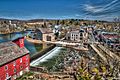
A view of Clinton, New Jersey with Red Mill (in the foreground) and the downtown district across the Raritan River (in the background)
-
Seal of Hunterdon County
-

Flag of Hunterdon County
-
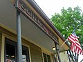
Oldwick General Store
-
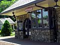
Whitehouse Station
See also
 In Spanish: Condado de Hunterdon para niños
