
High Bridge, New Jersey facts for kids
Quick facts for kids
High Bridge, New Jersey
|
|||
|---|---|---|---|
|
Borough
|
|||

High Bridge Reformed Church
|
|||
|
|||

Location of High Bridge in Hunterdon County highlighted in red (left). Inset map: Location of Hunterdon County in New Jersey highlighted in orange (right).
|
|||

Census Bureau map of High Bridge, New Jersey
|
|||

High Bridge, New Jersey
Location in Hunterdon County, New Jersey

High Bridge, New Jersey
Location in New Jersey

High Bridge, New Jersey
Location in the United States
|
|||
| Country | |||
| State | |||
| County | |||
| Incorporated | March 29, 1871 (as township) | ||
| Reincorporated | February 19, 1898 (as borough) | ||
| Government | |||
| • Type | Borough | ||
| • Body | Borough Council | ||
| Area | |||
| • Total | 2.43 sq mi (6.30 km2) | ||
| • Land | 2.39 sq mi (6.19 km2) | ||
| • Water | 0.04 sq mi (0.10 km2) 1.65% | ||
| Area rank | 378th of 565 in state 15th of 26 in county |
||
| Elevation | 295 ft (90 m) | ||
| Population
(2020)
|
|||
| • Total | 3,546 | ||
| • Estimate
(2023)
|
3,592 | ||
| • Rank | 428th of 565 in state 15th of 26 in county |
||
| • Density | 1,482.9/sq mi (572.6/km2) | ||
| • Density rank | 336th of 565 in state 5th of 26 in county |
||
| Time zone | UTC−05:00 (Eastern (EST)) | ||
| • Summer (DST) | UTC−04:00 (Eastern (EDT)) | ||
| ZIP Code |
08829
|
||
| Area code(s) | 908 Exchanges: 617, 638 | ||
| FIPS code | 3401931320 | ||
| GNIS feature ID | 0885251 | ||
High Bridge is a small town, called a borough, in Hunterdon County, New Jersey. In 2020, about 3,546 people lived there. This number was a little smaller than in 2010.
Contents
A Look at High Bridge's Past
_at_Bridge_Street_in_High_Bridge,_Hunterdon_County,_New_Jersey.jpg)
High Bridge became an official township on March 29, 1871. It was formed from parts of Clinton Township and Lebanon Township. Later, on February 19, 1898, it officially became a borough. The remaining parts of the original township went back to Clinton and Lebanon Townships.
The borough is located by the South Branch of the Raritan River. This river was important because its water powered one of the first ironworks in the United States. This ironworks was started in the 1740s by William Allen and Joseph Turner from Philadelphia.
In 1859, the Central Railroad of New Jersey started building a very tall and long bridge. This bridge was 112 feet (34 meters) high and 1,300 feet (400 meters) long. It crossed the river, and the town eventually got its name from this "High Bridge."
Exploring High Bridge's Geography
High Bridge covers about 2.43 square miles (6.30 square kilometers). Most of this area is land, with a small part being water. The South Branch Raritan River flows through the borough.
High Bridge shares its borders with two other towns in Hunterdon County: Clinton Township and Lebanon Township.
Some smaller areas and place names within High Bridge include Jericho Hill, Pierce Heights, and Silverthorn.
High Bridge's Climate
| Climate data for High Bridge, NJ | |||||||||||||
|---|---|---|---|---|---|---|---|---|---|---|---|---|---|
| Month | Jan | Feb | Mar | Apr | May | Jun | Jul | Aug | Sep | Oct | Nov | Dec | Year |
| Mean daily maximum °F (°C) | 37 (3) |
41 (5) |
50 (10) |
62 (17) |
72 (22) |
81 (27) |
85 (29) |
83 (28) |
77 (25) |
65 (18) |
54 (12) |
42 (6) |
62.416 (16.90) |
| Mean daily minimum °F (°C) | 19 (−7) |
22 (−6) |
28 (−2) |
38 (3) |
47 (8) |
57 (14) |
62 (17) |
61 (16) |
53 (12) |
41 (5) |
33 (1) |
25 (−4) |
40.5 (4.7) |
Population and People
| Historical population | |||
|---|---|---|---|
| Census | Pop. | %± | |
| 1880 | 2,209 | — | |
| 1890 | 1,935 | −12.4% | |
| 1900 | 1,377 | −28.8% | |
| 1910 | 1,545 | 12.2% | |
| 1920 | 1,795 | 16.2% | |
| 1930 | 1,860 | 3.6% | |
| 1940 | 1,781 | −4.2% | |
| 1950 | 1,854 | 4.1% | |
| 1960 | 2,148 | 15.9% | |
| 1970 | 2,606 | 21.3% | |
| 1980 | 3,435 | 31.8% | |
| 1990 | 3,886 | 13.1% | |
| 2000 | 3,776 | −2.8% | |
| 2010 | 3,648 | −3.4% | |
| 2020 | 3,546 | −2.8% | |
| 2023 (est.) | 3,592 | −1.5% | |
| Population sources: 1880–1920 1880–1890 1890–1910 1910–1930 1940–2000 2000 2010 2020 |
|||
How Many People Live Here?
The 2010 United States census counted 3,648 people living in High Bridge. There were 1,418 households, which are groups of people living together. Most of the people were White (93.17%). Other groups included Black or African American (1.32%), Native American (0.22%), and Asian (3.18%). About 6% of the population was Hispanic or Latino.
In 2010, about 33.6% of households had children under 18. Most households (58.3%) were married couples. The average household had 2.57 people. The average family had 3.06 people.
About 24.3% of the people were under 18 years old. The average age in High Bridge was 39.9 years.
High Bridge's Economy
High Bridge has a lively downtown area on Main Street. Here you can find restaurants, shops, and different services. One restaurant, Circa, has even been praised by The New York Times.
Local businesses work together through the High Bridge Business Association. This group helps businesses with advertising and promoting the town.
Fun and Recreation in High Bridge

High Bridge is the starting point of the Columbia Trail. This trail used to be a railroad line. It is now a path for walking and biking. The trail goes northeast from the center of town. It passes through a beautiful area called the Ken Lockwood Gorge.
Union Forge Park is the main public park in High Bridge. It is located near the South Branch Raritan River. Another park is the Borough Commons, which is at the start of the Columbia Trail.
The Taylor Steelworkers Historical Greenway is a 5.25-mile (8.45 km) path. It connects the town's parks and historic places. The High Bridge Hills golf course is also nearby for those who enjoy golf.
Learning and Schools
The High Bridge School District teaches students from pre-kindergarten through eighth grade. In the 2018–19 school year, there were 370 students in two schools:
- High Bridge Elementary School (Pre-K to 4th grade)
- High Bridge Middle School (5th to 8th grade)
After eighth grade, students go to Voorhees High School. This high school also serves students from several nearby towns. Voorhees High School is part of the North Hunterdon-Voorhees Regional High School District.
Before 1973, High Bridge had its own high school. But then, students started going to North Hunterdon Regional High School. In 1975, most high school students from High Bridge began attending Voorhees High.
Students in Hunterdon County can also apply to the Hunterdon County Vocational School District. This district offers special career and technical programs.
Getting Around High Bridge
_at_Arch_Street_in_High_Bridge,_Hunterdon_County,_New_Jersey.jpg)
Roads and Highways
As of 2010, High Bridge had about 21 miles (34 km) of roads. Most of these roads are kept up by the town itself. County Route 513 is the main road through High Bridge. It connects to Route 31 to the west. You can reach Interstate 78 by taking Routes 513 and 31.
Public Transportation
High Bridge was once an important spot for the Central Railroad of New Jersey. Today, the High Bridge station is the last stop on NJ Transit's Raritan Valley Line. The station has limited service on weekdays and no service on weekends. NJ Transit hopes to bring train service back to Phillipsburg in the future.
There is also a bus service called Hunterdon LINK Route 15. It travels between Flemington and Hampton.
Places to See and Visit
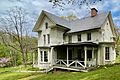
- Solitude House: Built around 1710–1725, this old house was once the center of an iron-making business. During the American Revolutionary War, important people like John Penn were held here. The Taylor family, who ran the iron business, lived in the house for many years. It was a museum from 2002 to 2012.
- Taylor Steel Workers Historical Greenway: This path connects to the Columbia Trail. It was created to highlight the history of the steelworkers in the area.
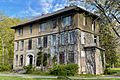
- TISCO Headquarters: Built in 1742, this is the oldest office building in New Jersey. It was built for the Union Iron Works.
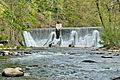
- Lake Solitude Dam: This dam, built in 1909, is a unique example of a "buttress dam" in New Jersey.
- Springside Farm: This farm was part of the Taylor Iron and Steel Company. It has buildings from 1803.
- Paul Robinson Observatory: This observatory is located in nearby Voorhees State Park. It is used by the New Jersey Astronomical Association for stargazing.
Images for kids
-
Solitude House
-
TISCO Office Building
-
Lake Solitude Dam


Famous People from High Bridge
Some notable people who have lived in or are connected to High Bridge include:
- Frank Baldwin (1928–2004), a baseball catcher for the Cincinnati Reds.
- Florence Howe Hall (1845–1922), a writer and speaker who supported women's right to vote.
- Naomi Jakobsson (born 1941), a politician who represented a district in the Illinois House of Representatives.
- Howard Menger (1922–2009), a writer known for his book The High Bridge Incident, which describes his childhood experiences with aliens.
- Dan Smith (born 1975), a former baseball pitcher for the Montreal Expos and Boston Red Sox.
- George W. Taylor (1808–1862), a general in the Union Army during the American Civil War.
See also
 In Spanish: High Bridge (Nueva Jersey) para niños
