
South Branch Raritan River facts for kids
Quick facts for kids South Branch Raritan River |
|
|---|---|

South Branch Raritan River flowing past Neshanic Mills
|
|
| Country | United States |
| State | New Jersey |
| Region | Hunterdon County Morris County Somerset County |
| Physical characteristics | |
| Main source | Budd Lake Budd Lake 40°51′48″N 74°45′07″W / 40.86333°N 74.75194°W |
| River mouth | Raritan River Branchburg 40°33′19″N 74°41′15″W / 40.55528°N 74.68750°W |
| Basin features | |
| River system | Raritan River |
The South Branch Raritan River is a river in central New Jersey, United States. It flows for about 50 miles (80 km). This river is a smaller stream that flows into the larger Raritan River.
Contents
Where the River Flows
The South Branch Raritan River starts at Budd Lake. This lake was formed by glaciers long ago. It is located near Hackettstown.
The river flows through three counties in New Jersey. It starts in Morris County. Then it goes through the middle of Hunterdon County. Finally, it flows along the western edge of Somerset County.
Joining the Raritan River
Near its end, the South Branch forms a border. It separates Branchburg and Hillsborough Townships. It then meets the North Branch Raritan River. Together, they form the main Raritan River. From this point, the Raritan River generally flows east.
The area where these two branches meet has a special history. The Lenape people, who lived there long ago, called it "Tucca-Ramma-Hacking." This means "the flowing together of water." Early European settlers called it "Two Bridges." This was because two bridges were built there in 1733. Today, people usually call this area "The Confluence."
Protecting the River
The South Branch Watershed Association is a local group that helps protect the river. A watershed is an area of land where all the water drains into a specific river or lake. Their goal is to "Protect the Water Resources of the South Branch of the Raritan River and its Watershed."
This group started in 1959. It is one of the oldest and largest watershed groups in New Jersey. It covers a large area of 276 square miles. This area includes 3 counties and 25 towns. The association helps by testing water wells for homeowners. They also teach people about the environment. They monitor the river's health and organize yearly river cleanups. They also work on restoring parts of the stream.
River Names
Both the North and South branches of the Raritan River flow mostly south. They run almost side-by-side, one to the east and one to the west. However, they get their names from the direction they flow from when they meet.
The small village of South Branch is located in Hillsborough Township.
River Views
-
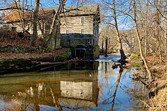
The river flowing past the Obediah Latourette Grist and Saw Mill in Long Valley
-
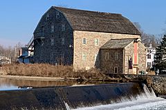
Dunham's Mill, which is now home to the Hunterdon Art Museum, and the Clinton Dam


Smaller Streams that Feed the River
Many smaller streams and brooks flow into the South Branch Raritan River. These are called tributaries. They add water to the main river as it flows.
- Allerton Creek
- Assicong Creek
- Beaver Brook
- Bushkill Brook
- Capoolong Creek
- Cramers Creek
- Drakes Brook
- Electric Brook
- Holland Brook
- Little Brook
- Minneaconing Creek
- Neshanic River
- Pleasant Run (also known as Campbell's Brook)
- Prescott Brook
- Spruce Run Brook (which includes Spruce Run Reservoir)
- Sidney Brook
- Stony Brook (in Washington Township, Morris County)
- Turkey Brook
Images for kids
-
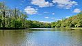
The place where the South Branch and the North Branch meet to form the Raritan River
-
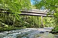
The Ken Lockwood Gorge Bridge


