
Clinton, New Jersey facts for kids
Quick facts for kids
Clinton, New Jersey
|
||
|---|---|---|
|
Town
|
||

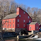
Red Mill (in foreground) and Clinton (in background) on the other side of the Raritan River
|
||
|
||

Location of Clinton in Hunterdon County highlighted in red (left). Inset map: Location of Hunterdon County in New Jersey highlighted in orange (right).
|
||

U.S. Census Bureau map of Clinton with Spruce Run State Park is in the Northwest corner of the map
|
||

Clinton, New Jersey
Location in Hunterdon County, New Jersey

Clinton, New Jersey
Location in New Jersey

Clinton, New Jersey
Location in the United States
|
||
| Country | ||
| State | ||
| County | Hunterdon | |
| Incorporated | April 5, 1865 | |
| Named for | DeWitt Clinton | |
| Government | ||
| • Type | Town | |
| • Body | Town Council | |
| Area | ||
| • Total | 1.44 sq mi (3.72 km2) | |
| • Land | 1.35 sq mi (3.49 km2) | |
| • Water | 0.09 sq mi (0.24 km2) 6.39% | |
| Area rank | 458th of 565 in state 18th of 26 in county |
|
| Elevation | 194 ft (59 m) | |
| Population
(2020)
|
||
| • Total | 2,773 | |
| • Estimate
(2023)
|
2,781 | |
| • Rank | 456th of 565 in state 18th of 26 in county |
|
| • Density | 2,059.4/sq mi (795.1/km2) | |
| • Density rank | 290th of 565 in state 3rd of 26 in county |
|
| Time zone | UTC−05:00 (Eastern (EST)) | |
| • Summer (DST) | UTC−04:00 (Eastern (EDT)) | |
| ZIP Code |
08809
|
|
| Area code(s) | 908 exchanges: 238, 328, 713, 735 | |
| FIPS code | 3401913720 | |
| GNIS feature ID | 0885189 | |

Clinton is a small town in Hunterdon County, New Jersey. It sits right on the South Branch of the Raritan River. In 2020, about 2,773 people lived here. Even though it's small, Clinton is an important stop for people traveling west on Interstate 78 from Newark.
Contents
History of Clinton
How Clinton Got Its Name
The town of Clinton was named in 1829. It got its name from DeWitt Clinton. He was the Governor of New York and helped build the famous Erie Canal.
Becoming a Town
Clinton officially became a town on April 5, 1865. It was formed from parts of three nearby townships. By 1895, Clinton was fully independent.
Famous Mills of Clinton
Clinton is well-known for its two historic mills. They sit on opposite sides of the South Branch Raritan River.
- The Red Mill was built in 1810. It first processed wool. Over the years, it handled grains, plaster, and even made peach baskets. It also generated electricity for the town.
- The Stone Mill is across the river. It was rebuilt in 1836 and worked as a gristmill until 1952. Today, it's home to the Hunterdon Art Museum.
The Great Fire of 1891
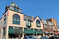
On October 30, 1891, a big fire hit Main Street. It destroyed 23 buildings and 17 businesses. This event is remembered as the Great Fire of 1891.
Solving a Big Problem
In 1988, Clinton faced a challenge with radon gas. Radon is a natural gas that can be harmful. The town, led by Mayor Robert A. Nulman, found ways to fix the problem. They used special ventilation systems in homes. Clinton became famous for successfully solving this issue.
Historic Buildings
Much of Clinton is part of the Clinton Historic District. This area was added to the National Register of Historic Places in 1995. It's important for its old buildings and history. There are 270 historic buildings in the district.
Geography and Climate
Where is Clinton?
Clinton is a small town, covering about 1.44 square miles (3.72 square kilometers). Most of this area is land, with a small part being water. The town is surrounded by other towns in Hunterdon County. These include Clinton Township, Franklin Township, and Union Township.
Climate in Clinton
Clinton is in the North Jersey climate zone. This area has a continental climate. This means it has clear seasons with warm summers and cold winters. The Atlantic Ocean doesn't affect the weather much here. Winters are usually colder than in other parts of New Jersey. The area gets about 40 to 50 inches (100 to 127 cm) of snow each year.
Population of Clinton
| Historical population | |||
|---|---|---|---|
| Census | Pop. | %± | |
| 1870 | 785 | — | |
| 1880 | 842 | 7.3% | |
| 1890 | 913 | 8.4% | |
| 1900 | 816 | −10.6% | |
| 1910 | 836 | 2.5% | |
| 1920 | 950 | 13.6% | |
| 1930 | 932 | −1.9% | |
| 1940 | 1,066 | 14.4% | |
| 1950 | 1,118 | 4.9% | |
| 1960 | 1,158 | 3.6% | |
| 1970 | 1,742 | 50.4% | |
| 1980 | 1,910 | 9.6% | |
| 1990 | 2,054 | 7.5% | |
| 2000 | 2,632 | 28.1% | |
| 2010 | 2,719 | 3.3% | |
| 2020 | 2,773 | 2.0% | |
| 2023 (est.) | 2,781 | 2.3% | |
| Population sources: 1870–1920 1870 1880–1890 1890–1910 1910–1930 1940–2000 2000 2010 2020 |
|||
In 2010, Clinton had 2,719 people living in 1,057 households. The population density was about 2,032 people per square mile. About 26% of the population was under 18 years old. The median age was 39.6 years.
Arts and Culture
Red Mill Museum Village
The Red Mill Museum Village is a popular spot in Clinton. It's located right in the town center on the South Branch Raritan River. The Red Mill was built in 1810 and has a long history. It was once a woolen mill and later processed other materials. Every October, the mill turns into a haunted house called the Red Mill Haunted Village. This event brings many visitors to Clinton. The Red Mill Museum Village was even on the TV show Ghost Hunters in 2008.
Hunterdon Art Museum
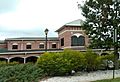
The Hunterdon Art Museum is in the historic Stone Mill, also known as Dunham's Mill. This building is listed on the National Register of Historic Places. The museum opened in 1952. It shows modern art, crafts, and designs from artists around the world. The museum also offers many art classes and workshops for kids and adults. They even have a summer camp program.
-
The Red Mill
-
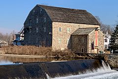
Hunterdon Art Museum in Dunham's Mill


Parks and Recreation
Clinton and the surrounding area offer fun outdoor activities:
- Landsdown Trail: This used to be a railroad line. Now it's a walking and biking trail. It starts south of Clinton and goes into the town center.
- Spruce Run Recreation Area: This large park is about 1,961 acres (7.94 km²). You can have picnics, go boating, fishing, and camping here. It's open all year.
- Round Valley Recreation Area: This area offers wilderness camping, beaches, trails, fishing, and boating.
Education
Local Schools
The Clinton-Glen Gardner School District serves students from Clinton Town and Glen Gardner Borough. Students in pre-kindergarten through eighth grade attend Clinton Public School. The district's name was changed in 2009 to include Glen Gardner. In the 2021-22 school year, there were 427 students in the school.
High School Choices
For high school, students in ninth through twelfth grades have two options. They can choose to attend North Hunterdon High School or Voorhees High School. Both are part of the North Hunterdon-Voorhees Regional High School District. Before 2014, Clinton students automatically went to North Hunterdon High.
Vocational School Options
Eighth-grade students from all over Hunterdon County can apply to the Hunterdon County Vocational School District. This district offers special career and technical programs. These programs help students learn skills for different jobs.
Transportation
Roads and Highways
Clinton has several important roads. The main highway is Interstate 78, which runs with U.S. Route 22. This highway connects Clinton to New York City and the Lehigh Valley in Pennsylvania. You can also get to Philadelphia from Clinton using New Jersey Route 31 and Interstate 295.
_at_Exit_15_(New_Jersey_State_Route_173_EAST,_Clinton,_Pittstown)_in_Clinton,_Hunterdon_County,_New_Jersey.jpg)
Public Transportation
- Buses: Trans-Bridge Lines offers bus service from nearby towns to the Port Authority Bus Terminal in Midtown Manhattan, New York City. There's a bus stop in Clinton.
- Trains: You can catch a train at the Annandale station on the Raritan Valley Line.
- The LINK: This is a public transportation service for Hunterdon County. It helps people get around the county.
Notable People
Many interesting people have lived in or are connected to Clinton:
- John T. Bird (1829–1911), a politician who represented New Jersey.
- Anna Case (1888–1984), a famous singer who recorded with Thomas Edison.
- Kyp Malone (born 1973), a musician from the band TV on the Radio.
- Barbara McClintock (born 1955), a children's book illustrator and author.
- Kyle Merber (born 1990), a runner who specializes in middle-distance races.
- James Valenti (born 1977), an opera singer.
- Sharon Van Etten (born 1981), a singer-songwriter.
- Foster McGowan Voorhees (1856–1927), a former Governor of New Jersey.
- Jessica Vosk (born 1983), a Broadway actress known for Wicked.
Images for kids
-
Main Street Bridge crossing the South Branch Raritan River
-
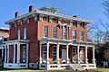
John Taylor Leigh Mansion, now the Municipal Building
-
Duckworth Building and Odd Fellows Hall on Main Street, redeveloped after the Great Fire of 1891.
-
North Branch County Library at 65 Halstead Street. It was built in 1999.
-
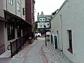
Alley named Allie's Way after a local teacher at Clinton Public School.


See also
 In Spanish: Clinton (Nueva Jersey) para niños
