
Raritan River facts for kids
Quick facts for kids Raritan River |
|
|---|---|

Raritan River as seen from Highland Park
|
|

|
|
| Other name(s) | Rariton |
| Country | United States |
| State | New Jersey |
| Counties | Hunterdon, Mercer, Middlesex, Monmouth, Morris, Somerset |
| Municipalities | Bridgewater Township, Raritan, Somerville, Bound Brook, South Bound Brook, Piscataway, Franklin Township, New Brunswick, Highland Park, Edison, East Brunswick, North Brunswick, Sayreville, Woodbridge, Perth Amboy, South Amboy |
| Physical characteristics | |
| Main source | Confluence of South Branch Raritan River and North Branch Raritan River 47.7 ft (14.5 m) 40°33′20.0″N 74°41′15.6″W / 40.555556°N 74.687667°W |
| River mouth | Raritan Bay 0 ft (0 m) 40°29′41.4″N 74°16′13.2″W / 40.494833°N 74.270333°W |
| Length | 69.6 mi (112.0 km) |
| Width |
|
| Depth |
|
| Basin features | |
| Basin size | 1,100 sq mi (700,000 acres; 2,800 km2) |
| Population | ~1.2 million |
| Tributaries |
|
| Bridges | Victory Bridge, Edison Bridge, Driscoll Bridge, New Jersey Turnpike, U.S. Highway No. 1 Bridge, highway bridge over South River at the town of South River |
The Raritan River is a major river in New Jersey, United States. It gets its water from the hilly, central part of the state. The river then flows into the Raritan Bay and finally reaches the Atlantic Ocean.
The Raritan River is about 69.6 miles (112 kilometers) long. It plays an important role in New Jersey's history and environment.
Contents
What is the Raritan River?
The Raritan River starts where two smaller rivers meet. These are the South Branch Raritan River and the North Branch Raritan River. This meeting point is near the towns of Somerville, Bridgewater, Branchburg, and Hillsborough.
How Does the River Flow?
The river flows for about 16 miles (25.7 kilometers). Then, it slows down into a wider area called a tidewater. This happens near New Brunswick. The river's wide mouth, called an estuary, stretches for another 14 miles (22.5 kilometers). It ends at the western part of Raritan Bay near South Amboy.
Why is the Raritan River Important?
The Raritan River has been a key water path for a long time. Its name comes from the Raritan Native American tribe. This Algonquian tribe used to live near Staten Island.
In early colonial times, the river helped industries grow around New Brunswick. During the American Revolutionary War, the river was used to move troops. It was a vital route for transportation.
Wildlife and River Health
Many efforts have been made to clean up the Raritan River. These actions have helped the fish and other animals that live there.
What Animals Live in the River?
You can find many types of fish in the river. These include largemouth bass, smallmouth bass, sunfish, catfish, trout, chain pickerel, American eels, carp, and yellow perch. Closer to the bay, you might see striped bass, fluke, winter flounder, weakfish, and bluefish.
Many birds also live along the river's banks. In the parts of the river where the tide flows, you can find blue claw crabs, fiddler crabs, and green crabs. Farther upstream, away from the ocean, you might even spot Crayfish.
The Raritan River and Rutgers University
The river is a popular spot for fun activities like boating. The rowing team from Rutgers University in New Brunswick uses the river for practice.
The Raritan River is even mentioned in Rutgers' school song, On the Banks of the Old Raritan. The song also talks about the river flooding. The musical 1776 also mentions soldiers bathing in the Raritan River.
Bridges and Transportation
Near where the river meets the bay, there are several important bridges. A New Jersey Transit railroad bridge crosses the river.
Major Bridges Over the Raritan
- The Victory Bridge carries Route 35. It connects Perth Amboy and Sayreville.
- The Edison Bridge carries U.S. Route 9. It links Woodbridge Township and Sayreville.
- The Driscoll Bridge carries the Garden State Parkway. This bridge also connects Woodbridge Township and Sayreville.
Drinking Water Supply
The Raritan River is a very important source of drinking water. It provides water for many people in the central part of New Jersey.
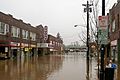
Flooding Concerns
The Raritan River can flood when there is a lot of rain. Heavy storms can cause the river to overflow its banks.
For example, in August 2011, there was record flooding. This happened after Hurricane Irene passed through the area.
Images for kids
-
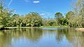
Confluence of the South Branch and the North Branch with the Raritan River in Branchburg
-
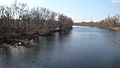
Raritan River viewed from Queens Bridge in Bound Brook
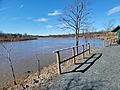
-
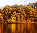
Raritan River at the Fall Line, as seen from Highland Park
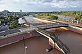
-
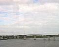
The Victory Bridge over Raritan River, as seen from the Edison Bridge in Sayreville
-
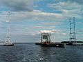
Raritan Bay Drawbridge in its open position, between Perth Amboy and South Amboy, right before the Raritan River drains out into the Raritan Bay
-
View of the Raritan River from the Edison Boat Basin
-
Flooding damage from Tropical Storm Irene in New Brunswick
-
The Raritan River flooding Bound Brook, Spring Nor'easter, April 16, 2007
-

A gauge inspector and the Manville gage house built into Van Veghten's Bridge abutment during the flood of December 31, 1948


