
Millstone River facts for kids
Quick facts for kids Millstone River |
|
|---|---|

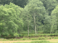
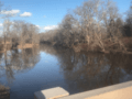
Millstone River at Rocky Hill
|
|

Map of northern section of Millstone River; see below for map of southern section
|
|
| Country | United States |
| Physical characteristics | |
| Main source | 40°11′58″N 74°24′48″W / 40.19944°N 74.41333°W |
| River mouth | 20 ft (6.1 m) 40°32′33″N 74°34′0″W / 40.54250°N 74.56667°W |
| Length | 38.6 mi (62.1 km) |
| Basin features | |
| Progression | Raritan River, Atlantic Ocean |
| River system | Raritan River system |
| Tributaries | |
The Millstone River is a 38.6-mile-long (62.1 km) river in central New Jersey, United States. It flows into the Raritan River. Think of it as a smaller river that feeds into a bigger one!
This river starts in western Monmouth County. It then flows north through southern Somerset County. Finally, it joins the Raritan River near Manville. For most of its journey, the Millstone River flows right next to the Delaware and Raritan Canal. Both the river and the canal are important. They provide drinking water for many homes and businesses in central New Jersey. They are also great places for outdoor fun!
| Top - 0-9 A B C D E F G H I J K L M N O P Q R S T U V W X Y Z |
Where the Millstone River Flows
.jpg)
The Millstone River begins in western Monmouth County. It starts near a road called CR-524 (Stage Coach Road). From there, it flows northeast, then turns north. It picks up smaller streams along the way.
The river crosses several roads like Sweetmans Lane and Baird Road. It also flows past the area that collects water for the Cranbury Brook. The Millstone River then turns west, crossing more roads like Perrineville Road. It receives many small streams that add to its water.

It flows under the New Jersey Turnpike and through the East Windsor Open Space. After crossing Route 130, it picks up another stream. It then flows into an area called Fischer Acres Associates. The river turns southwest after receiving Rocky Brook. Then, it makes a turn to the northwest.
Next, it flows west, crossing Old Trenton Road and John White Road. It also flows next to the West Windsor Planning Incentive area. The river receives water from Cranbury Brook and Bear Brook. It also gets water from Devils Brook. After crossing US-1, it flows into Carnegie Lake. Here, it crosses the Delaware and Raritan Canal, which it follows closely for the rest of its journey.

The river turns northeast, receiving Stony Brook. Then it turns north again. It receives Harrys Brook and leaves Carnegie Lake. It enters the D&R Canal State Park and crosses NJ27.
It receives Beden Brook and Simonson Brook. By this point, a road called CR-533 (River Road) runs alongside it. The river then receives Ten Mile Run and Six Mile Run. It flows past the Somerset Christian College. Finally, the Millstone River joins the Raritan River near Manville.
Understanding Flooding Along the River

The area around the Millstone River has experienced serious floods over the last 200 years. For example, Hurricane Floyd in September 1999 caused a very bad flood. This was especially true in the Lost Valley part of Manville. This area is on a flat flood plain between the Millstone River and the Raritan River. Another big flood happened after Hurricane Irene in 2011.

In 2016, the United States Army Corps of Engineers and the New Jersey Department of Environmental Protection studied the Millstone River Basin. They wanted to see if they could control or reduce flooding. The study focused on Manville because it was at the highest risk. However, they found that none of the ideas to reduce flooding were affordable. So, no federal action was recommended to lower the flood risk.
Drinking Water for Many Homes
The Millstone River is a very important source of drinking water. It provides water to thousands of homes and businesses in Central New Jersey. There's a special pumping station where the Millstone River meets the Raritan River. This station takes water from the river. The water is then cleaned and sent out by a company called New Jersey American Water.
The River's Role in History and Trade
In the early days of the American colonies, people used land routes more and more for trade. Goods were carried by stage coaches between important cities like New York City and Philadelphia. These coaches traveled a direct path from South Amboy to Bordentown. Later, this route became a railroad.

Many towns grew up along this stagecoach route. These towns included South Amboy, Sayreville, South River, Spotswood, Helmetta, Jamesburg, Cranbury, Hightstown, Windsor, Robbinsville, and Bordentown. The stagecoach route was usually a straight line between the Raritan Bay and the Delaware River.

As the country grew, large barges on canals became better for shipping heavy goods. Canals had to follow flat land, often riverbeds. This is why the Millstone River became so important. It provided a north-south waterway through New Jersey. This waterway connected the big cities of Philadelphia and New York.
The Millstone River is a key tributary of the Raritan River. The Raritan River flows into the Raritan Bay, which is part of the Atlantic Ocean. Raritan Bay is next to New York Harbor. It separates Staten Island (part of New York City) from Central New Jersey.
As the Raritan River flows east towards Raritan Bay, it meets the Millstone River near Bound Brook, New Jersey. The Millstone River flows through several New Jersey counties. It starts in Monmouth County. Then it flows west through Mercer County. After that, it goes northwest through Somerset County, and finally north towards Bound Brook.
The Delaware and Raritan Canal Connection
The Delaware and Raritan Canal runs along the east side of the Millstone River for most of its length. This canal starts near Lake Carnegie. It continues to where the Millstone River joins the main part of the Raritan River in Franklin Township.

The canal then continues along the right (south) bank of the Raritan River. The land between the canal and the river is a flood plain. This area usually has swamps, wooded areas, and some farms. There are also several spillways. These allow water to flow from the canal into the Millstone River when there's a lot of water.
In Lawrenceville, New Jersey, near U.S. Route 1, the canal connects to Trenton, the state capital. From Trenton, it flows into the Delaware River.
Because of the Millstone and Raritan Rivers, a major shipping route was created between New York and Philadelphia in the early 1800s. From New York, goods could be shipped north along the Hudson River and the Erie Canal. This allowed trade to reach upstate New York and even states near the Great Lakes.
Tributaries of the Millstone River
Many smaller streams and brooks flow into the Millstone River. These are called tributaries. They add water to the main river.
- Beden Brook
- Bear Brook
- Cranbury Brook
- Devils Brook
- Harrys Brook
- Heathcote Brook
- Indian Run Brook
- Little Bear Brook
- Millstone Brook
- Peace Brook
- Rocky Brook
- Royce Brook
- Simonson Brook
- Six Mile Run
- Stony Brook
- Ten Mile Run
- Van Horn Brook

Roads Crossing the Millstone River
Many roads and highways cross over the Millstone River. These crossings help people travel across New Jersey.
- New Jersey Route 33 in Millstone Township, New Jersey
- New Jersey Turnpike
- U.S. Route 130 connecting Cranbury Township, New Jersey to East Windsor Township, New Jersey
- U.S. Route 1 connecting Plainsboro Township, New Jersey to West Windsor Township, New Jersey
- New Jersey Route 27 connecting Kingston, New Jersey to Princeton, New Jersey
- County Route 518 connecting Griggstown, New Jersey to Rocky Hill, New Jersey
- Griggstown Causeway connecting Griggstown, New Jersey to Hillsborough, New Jersey
- Blackwell Mills
- Amwell Avenue
- Interstate 287
Images for kids
-
Millstone River flowing in Millstone Township (Monmouth County).
-
Peddie Lake in Hightstown (Mercer County).
-
Gordon Pond, a dammed section of Devils Brook in Plainsboro (Middlesex County).
-
Family fishing on Devils Brook on Thanksgiving.
-
Mill Pond Park, a dammed lake of Devils Brook.
-
Dam forming Lake Carnegie in Princeton (Mercer County).
-
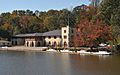
The boathouse, home to Princeton Rowing and the US Olympic rowing team.
-
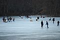
When the conditions are right, ice skating is a popular winter excursion for local residents to do on Lake Carnegie.
-
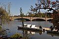
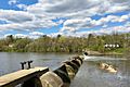
The Washington Road bridge crossing over the Millstone River and D&R Canal near Lake Carnegie.
-
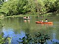
When the weather is right, the D&R Canal and its corresponding river attracts many rowers. Pictured in Princeton in Summer 2020.
-
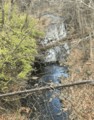
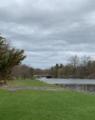
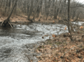
Brook flowing towards the main stem of the Millstone River in Rocky Hill (Somerset County).
-
Sylvan Lake in Skillman Park in Skillman (Somerset County).
-
Rock Brook flowing through Skillman Park.
-
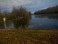
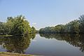
Millstone River near the eastern border of Hillsborough (Somerset County).
-
Millstone River flowing near Millstone Borough (Somerset County).
-
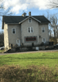
Millstone Wine & Liquor is located right along the Millstone River.
-
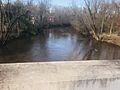
The Millstone River downstream under the Manville Causeway in Manville (Somerset County).
-
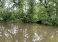
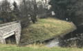
During Hurricane Henri, the Millstone River overflowed and nearly submerged a nearby pedestrian tunnel in the D&R Canal State Park near Kingston.
-
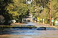
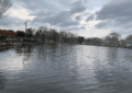
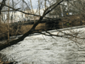
During Tropical Storm Ida, the Millstone River, and much of the Raritan Basin at large, suffered from massive flooding. Pictured here, is the Georgetown Franklin Turnpike bridge connecting Rocky Hill and Franklin Township overflowed by the Millstone River, with abandoned cars submerged in the floodwaters.
-
Mill Pond Park, a dammed lake of Devils Brook.

.png)


