Peters Brook (Stony Brook tributary) facts for kids
Quick facts for kids Peters Brook |
|
|---|---|

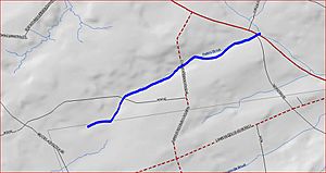
Map of Peters Brook
|
|
| Country | United States |
| Physical characteristics | |
| Main source | 40°22′37″N 74°51′55″W / 40.37694°N 74.86528°W |
| River mouth | 279 ft (85 m) 40°23′33″N 74°50′3″W / 40.39250°N 74.83417°W |
| Basin features | |
| Progression | Stony Brook (Millstone River), Millstone River, Raritan River, Atlantic Ocean |
| River system | Raritan River system |
Peters Brook is a small stream, also called a tributary, located in New Jersey, United States. It flows through parts of Mercer and Hunterdon counties. This brook eventually joins a larger stream known as Stony Brook.
The Journey of Peters Brook
Peters Brook begins its journey in New Jersey. Its starting point is near the intersection of Rock Road East and CR-601 (Mt Airy-Harbourton Road). From there, the brook flows towards the northeast.
As it travels, Peters Brook crosses a few roads. These include Rock Road East and CR-579, which is also known as Linvale-Harbourton Road.
The brook then flows past the Pine Creek Golf Course. After this, it crosses Route 31. Finally, Peters Brook empties its water into the Stony Brook. This is where its journey ends.
Black History Month on Kiddle
African-American Labor Activists
 | Bayard Rustin |
 | Jeannette Carter |
 | Jeremiah A. Brown |

All content from Kiddle encyclopedia articles (including the article images and facts) can be freely used under Attribution-ShareAlike license, unless stated otherwise. Cite this article:
Peters Brook (Stony Brook tributary) Facts for Kids. Kiddle Encyclopedia.
