
Rocky Hill, New Jersey facts for kids
Quick facts for kids
Rocky Hill, New Jersey
|
||
|---|---|---|
|
Borough
|
||

Dutch Reformed Church, built 1856, at the heart of the Rocky Hill Historic District
|
||
|
||

Location of Rocky Hill in Somerset County highlighted in yellow (right). Inset map: Location of Somerset County in New Jersey highlighted in black (left).
|
||

Census Bureau map of Rocky Hill, New Jersey
|
||

Rocky Hill, New Jersey
Location in Somerset County, New Jersey

Rocky Hill, New Jersey
Location in New Jersey

Rocky Hill, New Jersey
Location in the United States
|
||
| Country | ||
| State | ||
| County | ||
| Incorporated | December 18, 1889 | |
| Government | ||
| • Type | Borough | |
| • Body | Borough Council | |
| Area | ||
| • Total | 0.61 sq mi (1.59 km2) | |
| • Land | 0.61 sq mi (1.58 km2) | |
| • Water | 0.00 sq mi (0.01 km2) 0.49% | |
| Area rank | 539th of 565 in state 21st of 21 in county |
|
| Elevation | 108 ft (33 m) | |
| Population
(2020)
|
||
| • Total | 743 | |
| • Estimate
(2023)
|
740 | |
| • Rank | 545th of 565 in state 20th of 21 in county |
|
| • Density | 1,216.4/sq mi (469.7/km2) | |
| • Density rank | 358th of 565 in state 10th of 21 in county |
|
| Time zone | UTC−05:00 (Eastern (EST)) | |
| • Summer (DST) | UTC−04:00 (Eastern (EDT)) | |
| ZIP Code |
08553
|
|
| Area code(s) | 609 Exchanges: 252, 279, 430, 921, 924 | |
| FIPS code | 3403564320 | |
| GNIS feature ID | 0885376 | |

Rocky Hill is a small town, called a borough, in Somerset County, New Jersey. It's named after the Rocky Hill Ridge. This old village is in the Raritan Valley, right by the Millstone River.
In 2020, about 743 people lived here. This was a small increase from 682 people in 2010.
Contents
History of Rocky Hill
Early Settlement and Native Americans
The first European settlers came to this area in 1701. John Harrison bought land from the Lenape people. The Lenape were Native Americans who had lived here for hundreds of years. They spoke an Algonquian language. Lenape groups lived along the coast from Connecticut all the way to Maryland.
George Washington's Visits
In 1783, during the American Revolutionary War, General George Washington stayed at a house called Rockingham. This house belonged to the Berrien family. Washington visited the area again in 1789. He was on his way to New York City to become the first President of the United States.
Before roads were better, this area was sometimes called the Devil's Featherbed. It was very hard to travel through the rocky land with horses and wagons.
Becoming a Borough
Rocky Hill officially became a borough on December 18, 1889. This happened after people voted for it. It was created from parts of Montgomery Township.
Geography and Nature
Where is Rocky Hill?
Rocky Hill is a small place, about 0.61 square miles (1.59 square kilometers) in total. Most of it is land, with a tiny bit of water. A big part of Rocky Hill is taken up by Van Horne Park.
The borough is next to two other towns in Somerset County: Franklin Township and Montgomery Township.
Local Ecosystem
The natural plant life in Rocky Hill would mostly be Oak trees. It's part of what's called an Eastern Hardwood Forest. This means you'd find many different kinds of trees here.
Population and People
| Historical population | |||
|---|---|---|---|
| Census | Pop. | %± | |
| 1900 | 354 | — | |
| 1910 | 502 | 41.8% | |
| 1920 | 305 | −39.2% | |
| 1930 | 512 | 67.9% | |
| 1940 | 404 | −21.1% | |
| 1950 | 537 | 32.9% | |
| 1960 | 528 | −1.7% | |
| 1970 | 917 | 73.7% | |
| 1980 | 717 | −21.8% | |
| 1990 | 693 | −3.3% | |
| 2000 | 662 | −4.5% | |
| 2010 | 682 | 3.0% | |
| 2020 | 743 | 8.9% | |
| 2023 (est.) | 740 | 8.5% | |
| Population sources: 1900–1920 1900–1910 1910–1930 1940–2000 2000 2010 2020 |
|||
Who Lives in Rocky Hill?
In 2010, there were 682 people living in Rocky Hill. Most people were White (91.64%). There were also Black or African American, Asian, and people of other backgrounds. About 4.84% of the population was Hispanic or Latino.
The average household had about 2.40 people. The average family had about 2.95 people. About 23.2% of the people were under 18 years old. The median age was 45.9 years.
Education in Rocky Hill
Local Schools
Students in Rocky Hill go to schools in the Montgomery Township School District. This district has five schools. It serves students from pre-kindergarten all the way through twelfth grade.
The schools are:
- Orchard Hill Elementary School (Pre-K–2)
- Village Elementary School (grades 3–4)
- Montgomery Lower Middle School (grades 5–6)
- Montgomery Upper Middle School (grades 7–8)
- Montgomery High School (grades 9–12)
Rocky Hill also has a special school for younger children. It's called the Rocky Hill Cooperative Nursery School. It started in 1957.
Historic Places
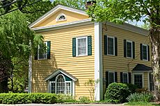
Rocky Hill Historic District
The Rocky Hill Historic District is a special area that protects the old parts of the town. It covers about 176 acres. The village started in the 1700s. It grew a lot in the 1800s. This was because it was a stop between Princeton and New Brunswick.
The district has 145 historic buildings. The most famous is the Dutch Reformed Church. It was built in 1856. This area was added to the National Register of Historic Places in 1982. This was because of its history, buildings, and business importance. Other nearby historic villages include Kingston and Harlingen.
-

The Rocky Hill Inn, built c. 1825–1830
-

Rocky Hill Community Center, built c. 1840
-
Former schoolhouse, built 1847–48
-

Parsonage for the Dutch Reformed Church, built 1858


Town Services
Emergency Help

The New Jersey State Police help keep Rocky Hill safe. Fire protection is provided by the Rocky Hill Hook & Ladder Co #1/Station 53 Fire.
The Rocky Hill First Aid and Rescue Squad (53 Rescue) provides emergency medical services. They help people who need urgent medical care. They also help other nearby towns.
Getting Around
_just_west_of_Somerset_County_Route_605_(Crescent_Avenue)_in_Rocky_Hill,_Somerset_County,_New_Jersey.jpg)
Rocky Hill has about 4.38 miles of roads. The main road is County Route 518. This road connects to other major routes like U.S. Route 206 and Route 27.
The closest airport is Princeton Airport. It's located in Montgomery Township, just west of Rocky Hill.
Healthcare
For medical care, people in Rocky Hill can go to Penn Medicine Princeton Medical Center. This is a large hospital in nearby Plainsboro Township. It's a teaching hospital and part of the Penn Medicine Health System.
Other hospitals close by include Robert Wood Johnson University Hospital in Somerville and New Brunswick. There's also Saint Peter's University Hospital in New Brunswick.
Famous People from Rocky Hill
Many interesting people have lived in or are connected to Rocky Hill:
- John Berrien (1711–1772): A judge in New Jersey and a leader at Princeton University.
- John Berrien Jr. (1759–1815): An army officer during the Revolutionary War.
- John Macpherson Berrien (1781–1856): Served as the United States Attorney General and a Senator for Georgia.
- Anthony Cassar (born 1996): A freestyle wrestler who won a national championship.
- Tom Malinowski (born 1965): A diplomat and politician who represents New Jersey in Congress.
- Stephen F. Voorhees (1878–1965): A famous architect who was president of the American Institute of Architects.
- George Washington: He stayed at the Berrien family's house, Rockingham, in 1783.
See also
 In Spanish: Rocky Hill (Nueva Jersey) para niños
