Duck Pond Run facts for kids
Quick facts for kids Duck Pond Run |
|
|---|---|

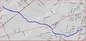
Map of Duck Pond Run
|
|
| Country | United States |
| Physical characteristics | |
| Main source | 40°17′40″N 74°37′21″W / 40.29444°N 74.62250°W |
| River mouth | 43 ft (13 m) 40°18′33″N 74°40′39″W / 40.30917°N 74.67750°W |
| Basin features | |
| Progression | Stony Brook (Millstone River), Millstone River, Raritan River, Atlantic Ocean |
| River system | Raritan River system |
Duck Pond Run is a small stream, also known as a tributary, located in Mercer County, New Jersey, in the United States. It flows into a larger stream called the Stony Brook. Think of it like a smaller road that connects to a bigger highway!
Where Does Duck Pond Run Flow?
Duck Pond Run begins its journey in West Windsor. Its starting point is around 40°17′40″N 74°37′21″W / 40.29444°N 74.62250°W.
As it flows, the stream travels west. It goes under roads like Penn Lyle Road and North Post Road. You can even see it as it passes through the Duck Pond Run park.
The stream then crosses Clarksville Road and continues through the West Windsor PL Project area. It also flows under a major road, Route 1.
Further along its path, Duck Pond Run winds through the Princeton Country Club. Finally, it passes under the historic Delaware and Raritan Canal. The stream then empties into the Stony Brook at 40°18′33″N 74°40′39″W / 40.30917°N 74.67750°W.
Other Streams Nearby
Duck Pond Run is not alone! It has several "sister" streams that also flow into the Stony Brook. These include:
 | John T. Biggers |
 | Thomas Blackshear |
 | Mark Bradford |
 | Beverly Buchanan |

