Stony Brook Branch facts for kids
Quick facts for kids Stony Brook Branch |
|
|---|---|

Map of Stony Brook Branch
|
|
| Country | United States |
| Physical characteristics | |
| Main source | 40°21′31″N 74°48′38″W / 40.35861°N 74.81056°W |
| River mouth | 151 ft (46 m) 40°21′6″N 74°47′2″W / 40.35167°N 74.78389°W |
| Basin features | |
| Progression | Stony Brook (Millstone River), Millstone River, Raritan River, Atlantic Ocean |
| River system | Raritan River system |
The Stony Brook Branch is a small stream, or tributary, that flows into a larger stream called the Stony Brook. It is located in Mercer County, New Jersey, in the United States. This stream is an important part of the local water system, eventually leading to the Atlantic Ocean.
Where Does Stony Brook Branch Start and End?
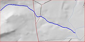
The Stony Brook Branch begins its journey in the Sourland Mountain area. You can find its starting point near Route 31 (Pennington Road) at these coordinates: 40°21′31″N 74°48′38″W / 40.35861°N 74.81056°W.
The Path of the Stream
From its start, the stream flows towards the east. It crosses under two roads: Route 31 and Pennington Hopewell Road. After flowing for a short distance, the Stony Brook Branch joins the Stony Brook. This meeting point is located at 40°21′6″N 74°47′2″W / 40.35167°N 74.78389°W.
Other Streams in the Area
The Stony Brook has several other smaller streams, or tributaries, that flow into it, just like the Stony Brook Branch. These streams are like sisters, all feeding into the same main waterway.
 | John T. Biggers |
 | Thomas Blackshear |
 | Mark Bradford |
 | Beverly Buchanan |

