Sourland Mountain facts for kids
Quick facts for kids Sourland Mountain |
|
|---|---|
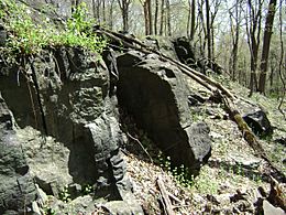
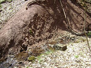
A ledge containing argillite hornfels visible on the east flank of Sourland Mountain in Hillsborough Twp.
|
|
| Highest point | |
| Peak | Northernmost peak |
| Elevation | 568 ft (173 m) |
| Dimensions | |
| Length | 17 mi (27 km) north–south |
| Geography | |
| Country | United States of America |
| Geology | |
| Age of rock | Triassic and Jurassic |
| Type of rock | intrusive igneous, extrusive igneous and trap rock |
Sourland Mountain is a long ridge in central New Jersey. It stretches about 17 miles (27 kilometers) from the Delaware River near Lambertville to Hillsborough Township. This area includes Montgomery Township and Hopewell Township.
Sourland Mountain is home to the largest unbroken forest in Central Jersey. This forest covers almost 90 square miles (233 square kilometers). Even though its highest point is only 568 feet (173 meters) above sea level, it rises sharply from the flat farmland around it. This is why people call it a 'mountain'. The ridge is part of a bigger area of rough land known as The Sourlands.
Contents
What's in a Name?
The name "Sourland" has a few possible origins. One idea is that it comes from "sorrel-land." This describes the reddish-brown soil that early German farmers found there. These soils have a lot of shale rock.
Another idea is that German immigrants from a region called Sauerland simply changed their home region's name. A third theory suggests that Dutch settlers in the 1600s called it "sauer landt." This meant "sour land" because it was not good for farming.
Even today, the area is not very developed. It's hard to farm there because of the tough rock and clay soils. The steep slopes and wet areas also make it difficult to dig wells or install septic systems.
A Look Back in Time
Before Europeans arrived, the Lenape people lived on Sourland Mountain. They spoke the Unami language. It seems their villages and farms were mostly in the river valleys. This was because the soil higher up on the mountain was poor and rocky. There is proof that a Lenape village existed near the Delaware River. This was at the southern base of the mountain, where Lambertville is now.
In the 1700s and 1800s, people used the mountain's many streams. They powered different mills with the water. Sourland Mountain also became an important source of wood. However, by the time of the Civil War (around 1860s), most of the mountain's forests were gone.
After the forests were cut down, farms appeared on the easier parts of the mountain. Small villages also formed. People started rock quarries and a local pottery business around this time.
By the late 1800s, Sourland Mountain had a successful peach farming industry. But a plant disease hit just before the 1900s. Also, New Jersey started focusing more on factories than farming. This caused farming on the mountain to decline. The small villages disappeared, and new forests began to grow over the old farmlands.
Only one industry from before the 1900s continued into modern times: rock quarrying. The mountain's hard trap rock was crushed. It was used to build railroad tracks and roads throughout the region.
For the first half of the 1900s, Sourland Mountain remained a quiet, remote place. It had few connections to nearby cities. This changed in the 1940s when new roads made the mountain easier to reach. This allowed suburban areas to start growing into its valleys and slopes. Today, the mountain provides water for nearby towns. It also offers fun outdoor activities for people in Central New Jersey.
Mountain Shape and Features
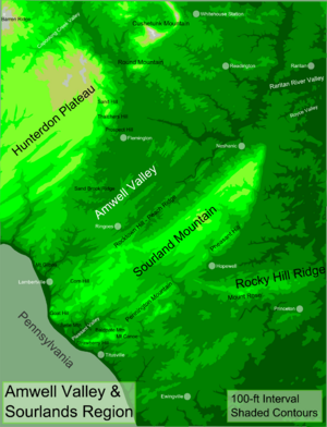
Sourland Mountain is a range that includes the main ridge and smaller ridges next to it. In the northern part, Pheasant Hill runs alongside the main ridge. South of Pheasant Hill, Pennington Mountain forms another ridge. This same ridge continues south, breaking into three more parts. These are Mount Canoe, Baldpate Mountain, and Strawberry Hill.
A small hill called Belle Mountain sits in the valley between Strawberry Hill and the main ridge's southern end. Goat Hill is the highest point of the main ridge before it reaches the Delaware River.
Next to Sourland Mountain is a large ridge of traprock. It stretches east from Pennington Mountain for about nine miles. This ridge forms Mount Rose, Rocky Hill, and Ten Mile Run Mountain.
West of the main ridge, near Flemington, is Prospect Hill. This hill is an old volcano part. It lies on the western edge of the Amwell Valley. Prospect Hill seems to be connected to Sourland Mountain by a volcanic dike. This dike runs mostly underground.
How the Mountain Was Formed
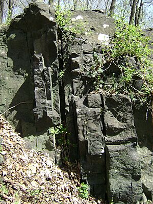
Sourland Mountain was created 200 million years ago. Hot, melted rock, called diabase, pushed its way into softer rock called Brunswick Shale. This happened when huge forces in the Earth's crust created the Newark Basin. This was a giant valley that formed as North America and Africa began to split apart. The parallel ridges of the mountain likely formed as magma flowed up through cracks in the Earth during this splitting process.
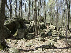
During the early Jurassic period, the splitting that formed the Newark Basin stopped. The melted rock that would become Sourland Mountain also stopped growing. Most of this volcanic material stayed deep underground. However, the diabase and hornfels rocks that make up the mountain are very hard. They resist erosion well. Over millions of years, the softer shale rock around them wore away. This left the harder diabase and hornfels as the elevated ridges we see today.
The Palisades Sill in northeastern New Jersey and southeastern New York formed in a similar way. It is also partly connected to Sourland Mountain. The ridge that forms Mount Rose, Rocky Hill, and Ten Mile Run Mountain is a continuation of the Palisades. It connects to Pennington Mountain. South of Pennington Mountain, the Palisades sill and Sourland Mountain's eastern ridge are essentially the same feature.
Like the Palisades, Sourland Mountain has volcanic dikes. These are cracks filled with hardened magma that extend away from the main ridge. One such dike goes northwest from Sourland Mountain. It is believed to have created Prospect Hill. Prospect Hill is a peak near Flemington, New Jersey, where magma actually erupted to the surface. It is the only known place where Sourland Mountain's magma broke through.
One key difference between Sourland Mountain and other volcanic mountains in the Newark Basin, like the Watchungs and the Palisades, is that glaciers never touched it. This left a layer of argillite rock from the Triassic period covering much of the mountain's hard rock. This argillite makes up most of Pheasant Hill. The argillite does not let water pass through easily. This is the main reason why Sourland Mountain has very little groundwater.
Amazing Plants and Animals
Sourland Mountain is part of the Northeastern coastal forests ecoregion. It is a special natural area. It is home to many rare and endangered plants and animals, including:
- Trout lilies
- Wood anemones
- Ginseng
- Spotted salamander
- Pileated woodpecker
- Bobcat
- Wood turtle
- Barred owl
- Bobolink
- Cooper's hawk
- Grasshopper sparrow
- Savannah sparrow
- Upland sandpiper
- Scarlet tanager
The Sourlands are an important stop for birds that migrate. These birds travel between South and Central America and the Arctic. Forest birds also stop here on their way between Washington, D.C. and Boston. The area also supports many birds that live deep in the woods, like scarlet tanagers and barred owls.
This forest is the largest unbroken forest between the Pine Barrens and the New Jersey Highlands. This makes it very important for the survival of birds that migrate long distances. It is also vital for other rare plants and animals. The D&R Greenway Land Trust works with a group in Mexico, Amigos de Calakmul. They protect bird homes at the southern end of the birds' migration path.
Fun Things to Do
Sourland Mountain has small parks and places to enter. This makes it popular for many outdoor activities. You can go hiking, mountain biking, hunting, and bird watching. Rock climbing is allowed in some parks, like Sourland Mountain Preserve in Somerset County. But it is not allowed in others, like Sourland Mountain Nature Preserve in Hunterdon County. The biggest park is the Sourland Mountain Preserve in Somerset County. The Sourland Mountain Nature Preserve is also nearby, located in Hunterdon County.
Famous People from the Mountain
Some notable people who have lived on Sourland Mountain include:
- Eugene O'Neill, a famous writer of plays.
- Charles Lindbergh, a well-known pilot.
- John Hart, a patriot who signed the Declaration of Independence.
- George Bellows, a painter.
- Sylvia Dubois, a freed slave who owned a tavern.
 | Janet Taylor Pickett |
 | Synthia Saint James |
 | Howardena Pindell |
 | Faith Ringgold |


