
Delaware River facts for kids
Quick facts for kids Delaware River |
|
|---|---|

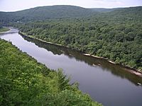
The Delaware River flowing through the Delaware Water Gap, which divides New Jersey and Pennsylvania, in 2021
|
|

Map of the Delaware River watershed, showing major tributaries and cities
|
|
| Country | United States |
| State | New York, New Jersey, Pennsylvania, Delaware, and Maryland, U.S. |
| Cities | Margaretville, NY, Delhi, NY, Deposit, NY, Hancock, NY, Callicoon, NY, Lackawaxen, PA, Port Jervis, NY, Stroudsburg, PA, Easton, PA, New Hope, PA, Trenton, NJ, Camden, NJ, Philadelphia, PA, Chester, PA, Wilmington, DE, Salem, NJ, Dover, DE |
| Physical characteristics | |
| Main source | West Branch Mount Jefferson, Town of Jefferson, Schoharie County, New York, United States 2,240 ft (680 m) 42°27′12″N 74°36′26″W / 42.45333°N 74.60722°W |
| 2nd source | East Branch Grand Gorge, Town of Roxbury, Delaware County, New York, United States 1,560 ft (480 m) 42°21′26″N 74°30′42″W / 42.35722°N 74.51167°W |
| River mouth | Delaware Bay Delaware, United States 0 ft (0 m) 39°25′13″N 75°31′11″W / 39.42028°N 75.51972°W |
| Length | 301 mi (484 km) |
| Discharge (location 2) |
|
| Basin features | |
| Basin size | 13,539 sq mi (35,070 km2) |
| Tributaries | |
| Type: | Scenic, Recreational |
The Delaware River is a really important river in the eastern United States. It's special because it's the longest major river in the East that flows freely, meaning it doesn't have any dams blocking its main path.
The river starts where its two main branches meet in Hancock, New York. From there, it flows for about 282 miles (454 km). It creates borders between the states of New York, Pennsylvania, New Jersey, and Delaware. Finally, it empties into Delaware Bay.
The National Wildlife Federation calls the Delaware River one of America's "Great Waters." It's also known as the "Lifeblood of the Northeast" by American Rivers. The land area that drains into the river, called its watershed, covers about 13,539 square miles (35,060 km²). This river system provides drinking water for a huge number of people, around 17 million! This includes half of New York City's water, which travels through the Delaware Aqueduct.
The Delaware River has two main parts, or branches, that begin in the Catskill Mountains in New York. The West Branch starts near Mount Jefferson. The East Branch begins at Grand Gorge. These two branches join together to form the main Delaware River at Hancock, New York.
As the river flows south, much of it remains natural and undeveloped. About 152 miles (245 km) of the river are protected as part of the National Wild and Scenic Rivers System. When the river reaches Trenton, New Jersey, it becomes a tidal river. This means its water levels are affected by the ocean's tides. This part of the river is also used for shipping and industry. It runs through big cities like Philadelphia, Camden, New Jersey, and Wilmington, Delaware. The river then flows into Delaware Bay.
Long ago, before European settlers arrived, the Lenape Native American people lived along the river. They called it Lenapewihittuk, which means "Lenape River." They also called it Kithanne, meaning the largest river in this area.
In 1609, an explorer named Henry Hudson visited the river. He was working for the Dutch East India Company. His visit led to the Dutch starting colonies in North America. Early Dutch and Swedish settlers called the river the South River. This was to tell it apart from the Hudson River, which they called the North River.
Later, in 1664, the English took control from the Dutch. They renamed the river Delaware. It was named after Thomas West, 3rd Baron De La Warr, an English nobleman. He was the first royal governor of the Virginia colony. A very important moment in American history happened on this river. In 1776, George Washington's crossing of the Delaware River helped the Americans win the Battle of Trenton. This was a key victory in the American Revolution.
Contents
Why is it Called the Delaware River?

The Delaware River got its name from Thomas West, 3rd Baron De La Warr (1577–1618). He was an English nobleman and the first royal governor of the Virginia colony. He helped protect the colony during a conflict called the First Anglo-Powhatan War. Lord de la Warr arrived with soldiers and is remembered for saving the Virginia colony. The name "Delaware" is pronounced "DEL-ə-wair" and might come from the French phrase de la Guerre.
Many people think the river was named Delaware after the English took control from the Dutch in 1664. However, the river and bay were actually known as Delaware as early as 1641. The state of Delaware was once part of William Penn's Pennsylvania colony. In 1682, the Duke of York gave Penn access to the sea. This land along the western shore of Delaware Bay became known as the "Lower Counties on the Delaware." These counties later gained their own government in 1704. They became a separate state after the United States was formed.
The name "Delaware" also became a common name for the Lenape people. They were a Native American group living in the areas around the Susquehanna River, Delaware River, and lower Hudson River. Because the Lenape people moved to different places over time, the name "Delaware" is now used for towns, counties, and other places in the American Midwest and Canada.
What is the Delaware River Watershed?

A watershed is an area of land where all the water drains into a single river or body of water. The Delaware River's watershed is huge! It covers about 13,539 square miles (35,060 km²). This area includes 42 counties and 838 towns in five U.S. states: New York, New Jersey, Pennsylvania, Maryland, and Delaware. This is about 0.4% of all the land in the United States. In 2001, about 68% of the watershed was covered by forests.
There are 216 smaller streams and creeks that flow into the Delaware River. Together, these smaller waterways stretch for an estimated 14,057 miles (22,622 km). Even though about 4.17 million people live in the watershed, these waters provide drinking water for 17 million people. That's about 6% of the entire U.S. population!
The waters of the Delaware River basin are used for many things. These include fishing, transportation, power, cooling, recreation, and other industrial and home uses. The Delaware is the 33rd largest river in the U.S. by how much water flows through it. But it's one of the most used rivers for daily freight shipping. The average amount of water flowing through the Delaware at Trenton, New Jersey is 11,700 cubic feet per second. Since there are no dams on the main part of the river, it's one of the few large free-flowing rivers left in the United States.

-

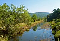
East Branch of the Delaware River near Margaretville, New York.
-
Canoeing on the river at Hawk's Nest, New York.
-
A still remaining section of the Delaware and Hudson Canal seen from U.S. 209 near Summitville, New York.
-
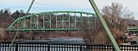
Easton–Phillipsburg Toll Bridge crosses the Delaware, connecting Easton, Pennsylvania and Phillipsburg, New Jersey in the Lehigh Valley.
-
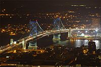
Benjamin Franklin Bridge crosses the Delaware, connecting Philadelphia and Camden, New Jersey.
-
Walt Whitman Bridge crosses the Delaware, connecting Philadelphia and Gloucester City, New Jersey.
-
Dingman's Ferry Bridge connects Sandyston Township, New Jersey and Delaware Township in Pike County, Pennsylvania.
-
The Delaware within the southern portion of the Delaware Water Gap National Recreation Area, near Worthington State Forest in New Jersey.
-
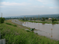
A flood in Westfall, Pennsylvania, in 2006.


The River's Journey: Its Course
Where Does the West Branch Start?
The West Branch of the Delaware River is also known as the Mohawk Branch. It stretches about 90 miles (140 km) from the northern Catskill Mountains. It meets the East Branch at Hancock, New York. The last 6 miles (9.7 km) of this branch form part of the border between New York and Pennsylvania.
The West Branch starts in Schoharie County, New York, about 1,886 feet (575 m) above sea level. It flows through mountains and towns like Stamford and Delhi. Near Stilesville, the West Branch was dammed in the 1960s to create the Cannonsville Reservoir. This reservoir is part of the New York City water supply system. It holds a lot of water, about 95.7 billion US gallons (362 million m³). This water travels through a long tunnel to other reservoirs and then into the Delaware Aqueduct. This aqueduct provides about half of New York City's drinking water. The West Branch joins the East Branch at Hancock to form the main Delaware River.
Where Does the East Branch Start?
The East Branch also starts from a small pond. It's located south of Grand Gorge in Delaware County. This branch also flows southwest and is used by New York City. It forms the Pepacton Reservoir, which is the largest reservoir in the New York City water supply system. The Beaver Kill River and the Willowemoc Creek are two smaller rivers that flow into the East Branch. The East Branch and West Branch flow side-by-side in a southwesterly direction. They meet just south of Hancock.
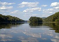
The Upper Delaware Valley: Scenic Views
From Hancock, New York, the Delaware River flows between the northern Poconos in Pennsylvania and the Catskills. It travels through a wide valley in the Appalachian Mountains. You can see amazing views like the Hawk's Nest overlook along the Upper Delaware Scenic Byway. The river flows southeast for 78 miles (126 km) through quiet, rural areas along the New York-Pennsylvania border. It reaches Port Jervis and the Shawangunk Ridge.
The Minisink: A Hidden Valley
At Port Jervis, the Delaware River enters a special area called the Minisink Valley. Here, the river flows through a bed of glacial material that filled an old valley during the last glacial period. It then goes around the Kittatinny ridge. The river cuts through this ridge at the Delaware Water Gap. This is a famous spot with tall, nearly vertical rock walls made of sandstone and other rocks. After this, the river flows through beautiful countryside with farms and forests. It then enters hills again at Easton, Pennsylvania. From Easton, the river is sometimes bordered by nice hills and cliffs. The Nockamixon Cliffs are especially impressive, being 3 miles (4.8 km) long and over 200 feet (61 m) high.
The Appalachian Trail, a famous hiking path, crosses the Delaware River at the Delaware Water Gap.
Central Delaware Valley: Where Rivers Meet


In Easton, Pennsylvania, another important river, the Lehigh River, joins the Delaware. At Trenton, the Delaware River crosses the Atlantic Seaboard Fall Line. This is a natural boundary where the land drops about 8 feet (2.4 m). This drop marks where the river becomes tidal.
Lower Delaware and Tidewater: To the Bay
Below Trenton, the Delaware River flows between Philadelphia and New Jersey. It becomes a wide, slow-moving inlet of the sea. There are many marshes along its sides. It gets wider and wider until it forms the large Delaware Bay.
The Delaware River forms the border between Delaware and New Jersey. Interestingly, the border is actually at the eastern shoreline of the river within a special area called the Twelve-Mile Circle of New Castle. This means some small pieces of land on the New Jersey side are actually under Delaware's control. The rest of the border follows the middle of the river.
History of the Delaware River

When Europeans first arrived in the early 1600s, the Lenape Native American people lived near the Delaware River. They called it "Lenape Wihittuck," meaning "the rapid stream of the Lenape." The Delaware River was very important for the growth of the Mid-Atlantic region. In the 1600s, it was a pathway for Dutch and Swedish settlers to create colonies. Later, in 1664, the English took over. Quakers then settled and established the colonies of Pennsylvania and West Jersey.
In the 1700s, cities like Philadelphia, Camden, Trenton, Wilmington, and New Castle grew up along the Delaware. Their success depended on using the river for trade and power. The river also helped German immigrants settle in northeastern Pennsylvania and northwestern New Jersey. These settlers were important for farming in the region.
The Delaware River in the American Revolution


The Delaware River was a key location during the American Revolutionary War. One of the most famous events was George Washington's crossing of the Delaware River. On the night of December 25–26, 1776, Washington and his Continental Army secretly crossed the icy river. This led to a surprise attack and victory against the Hessian troops in Trenton, New Jersey on December 26. This battle was a major turning point in the war.
During the Philadelphia Campaign, the British needed to control the Delaware River. This would allow their ships to supply their troops in Philadelphia. Because of this, battles like the Battle of Red Bank and the Siege of Fort Mifflin were fought on and along the river.
Canals Connected to the Delaware River
In the past, canals were built to connect the Delaware River to other waterways. This helped with trade and transportation before railways became common.
- The Delaware Division of the Pennsylvania Canal ran next to the river from Easton to Bristol. It opened in 1830.
- The Delaware and Raritan Canal runs along the New Jersey side of the Delaware River. It connects the Delaware and Raritan rivers. This canal is still used today to supply water to New Jersey.
- The Morris Canal and the Delaware and Hudson Canal once connected the Delaware and Hudson rivers. These canals are now mostly gone.
- The Chesapeake and Delaware Canal links the Delaware River with the Chesapeake Bay.
Delaware Water Gap National Recreation Area
The Delaware Water Gap National Recreation Area was created because a plan to build a dam on the Delaware River failed. The dam, called the Tocks Island Dam, was meant to control floods and create electricity. It would have made a 37-mile (60 km) long lake. Starting in 1960, the government bought land for this dam project. Between 3,000 and 5,000 homes were torn down, and about 15,000 people had to move.
However, many environmental groups opposed the dam. There were also money problems and concerns about the dam's safety due to the ground. So, in 1978, the government gave the land to the National Park Service. The Park Service then worked to create recreational areas and protect the remaining historical sites.
American Rivers, an environmental group, named the Delaware River the "River of the Year" for 2020. They recognized the great progress made over 75 years in reducing pollution and bringing back wildlife.
How is the Delaware River Used Today?
Wine Regions Along the River
In 1984, a special wine region was created along the Delaware River. It's called the Central Delaware Valley AVA (American Viticultural Area). This area is in southeastern Pennsylvania and New Jersey. It covers about 96,000 acres (39,000 ha) around the river, north of Philadelphia and Trenton.
Shipping and Ports
The Delaware River is very important for shipping. Since 1941, the main shipping channel has been kept at a depth of 40 feet (12 m). There's even a plan to make it 45 feet (14 m) deep from Philadelphia to the Delaware Bay.
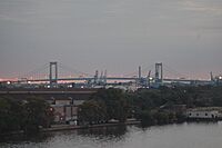
The Delaware River port complex includes several ports and energy facilities. These are located along the river in Pennsylvania, New Jersey, and Delaware. Some of the major ports are the Port of Salem, Port of Wilmington, Port of Chester, Port of Paulsboro, Port of Philadelphia, and Port of Camden. Together, they form one of the largest shipping areas in the United States. In 2015, these ports handled 100 million tons of cargo. They supported about 135,000 jobs. The biggest imports were fruit and petroleum. The biggest export was containerized cargo.
The river was once a major center for oil and chemical products. Many refineries and chemical plants were located along its banks. In 2011, crude oil was the largest single product transported on the Delaware River. It made up half of all the cargo shipped each year.
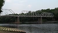
Bridges and Crossings
The Delaware River is a big natural barrier between New Jersey and Pennsylvania. Many bridges cross the river. Most of the larger bridges charge a toll only when you travel westbound. These bridges are managed by different organizations, like the Delaware River and Bay Authority and the Delaware River Port Authority.
Environmental Concerns and Flooding
New York City's Water Supply
New York City built many reservoirs to supply water to its growing population. In 1928, the city decided to take water from the Delaware River. This caused problems with towns in Pennsylvania that also used the river for water. The issue went to the U.S. Supreme Court. In 1931, New York City was allowed to take 440 million US gallons (1.7 million m³) of water per day from the Delaware and its smaller rivers.
Pollution in the River
The Delaware River has faced problems with pollution. In 2012, it was named the 5th most polluted river in the United States by environmental groups. They claimed that millions of pounds of toxic chemicals were flowing into the river from factories. These chemicals could cause health problems like birth defects and cancer.
In 2015, the EPA stepped in. They found that the river did not meet the standards of the Clean Water Act. This law says rivers should be safe for fishing and swimming. The EPA worked with a local water authority to clean up the river. They planned to spend about $200 million to remove a lot of sewage and pollution. The water authority was also fined for not following the Clean Water Act. Even with cleanup efforts, the Delaware River in the Philadelphia/Chester area still isn't fully safe for swimming or fishing.
In March 2023, a pipe broke at a chemical plant in Bristol, Pennsylvania. This caused over 8,000 gallons of a chemical material to spill into a small stream that flows into the Delaware River. This led to a water advisory in Philadelphia.
Flooding Along the Delaware
Since the dam project was canceled, the river doesn't have much flood control. This means it can flood badly after heavy rain or snowmelt. In August 1955, record flooding happened after two hurricanes passed over the area. The river reached an all-time high of 38.85 feet (11.84 m) at Riegelsville.
More recently, there have been several serious floods. In 2004, 2005, and 2006, the river flooded significantly. The upper part of the Delaware basin doesn't have many towns, so flooding there mostly affects natural areas. But in the middle part of the basin, residents have seen their homes and land badly damaged by floods. The lower part of the river, from Philadelphia to the Delaware Bay, is wider and affected by tides. It usually doesn't have river-related flooding, though tidal surges can cause minor floods.
The Delaware River Basin Commission and local governments are working to solve the flooding problem. Many residents feel that something must be done, especially with more severe floods happening. They are working with FEMA (Federal Emergency Management Agency), but progress is slow due to limited funds.
Oil Spills in the River
Several oil spills have happened in the Delaware River over the years:
- January 31, 1975: About 11.17 million US gallons (42.3 million L) of crude oil spilled from a tanker called Corinthos.
- September 28, 1985: 435,000 US gallons (1.65 million L) of crude oil spilled from the Grand Eagle tanker.
- June 24, 1989: 306,000 US gallons (1.16 million L) of crude oil spilled from the Presidente Rivera tanker.
- November 26, 2004: 265,000 US gallons (1.00 million L) of crude oil spilled from the Athos 1 tanker. Its hull was punctured by a hidden anchor. In 2020, the Supreme Court ruled that the company responsible had to pay $143 million for cleanup costs.
Atlantic Sturgeon: An Endangered Fish
The National Marine Fisheries Service is thinking about naming sixteen rivers, including the Delaware, as endangered habitats for the Atlantic sturgeon. This would mean more care would be needed to protect these fish from human activities in the rivers.
National Wild and Scenic River Status
A part of the Delaware River is officially recognized as a National Wild and Scenic River. This status helps protect its natural beauty and importance.
Images for kids
-
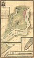
A historical map of the 1777 Philadelphia Campaign.

See also
 In Spanish: Río Delaware para niños
