
Schoharie County, New York facts for kids
Quick facts for kids
Schoharie County
|
||
|---|---|---|
|
Left to right, from top: Schoharie County Courthouse, Old Stone Fort (Schoharie, New York), Lean-to at the summit of Huntersfield Mountain, Dr. Christopher S. Best House and Office, Lansing Manor House, view from Vroman's Nose
|
||
|
||

Location within the U.S. state of New York
|
||
 New York's location within the U.S. |
||
| Country | ||
| State | ||
| Founded | 1795 | |
| Seat | Schoharie | |
| Largest village | Cobleskill | |
| Area | ||
| • Total | 626 sq mi (1,620 km2) | |
| • Land | 622 sq mi (1,610 km2) | |
| • Water | 4.5 sq mi (12 km2) 0.7% | |
| Population
(2020)
|
||
| • Total | 29,714 |
|
| • Density | 47.5/sq mi (18.3/km2) | |
| Time zone | UTC−5 (Eastern) | |
| • Summer (DST) | UTC−4 (EDT) | |
| Congressional district | 21st | |


Schoharie County (pronounced skoh-HAIR-ee) is a county in New York. In 2020, about 29,714 people lived here. This makes it the fifth-least populated county in the state. The main town, or county seat, is Schoharie. The name "Schoharie" comes from a Mohawk word. It means "floating driftwood." Schoharie County is part of the larger Albany-Schenectady-Troy area. It is also in the Mohawk Valley region of New York.
Contents
History of Schoharie County

Long ago, the Mohawk Nation lived in this large area. To the west, other tribes of the Iroquois (Haudenosaunee) Confederacy also lived here. When Europeans came, the Mohawk people traded furs. They traded with the French, Dutch, British, and German settlers.
In the 1720s and 1730s, some Palatine Germans settled here. They had worked on the Hudson River to pay for their trip to America. Also, Scots-Irish immigrants came to Schoharie County. They settled here before the American Revolutionary War.
Revolutionary War in Schoharie
Schoharie County was a place of fighting during the American Revolutionary War. Settlers on the frontier faced attacks from the British and their Native American allies. Four of the six Iroquois tribes joined the British. They hoped to push the colonists out of their lands.
Geography of Schoharie County
Schoharie County covers about 626 square miles. Most of this is land, about 622 square miles. The rest, about 4.5 square miles, is water.
The county is in central New York State. It is west of Albany and southeast of Utica.
Much of the southern part of the county is in the Catskill Mountains. The land rises quickly from the Schoharie Creek. This creek runs through the middle of the county. The northern part of the county has small hills and valleys. More than 75% of the people live in the north. This area is closer to the Mohawk River. The Mohawk River was an important travel route.
The Schoharie Creek flows north into the Mohawk River. Its watershed covers about 950 square miles. The creek has two dam and reservoir systems. The Gilboa Dam and Schoharie Reservoir are part of New York City's water supply. The Blenheim-Gilboa Dam creates hydroelectric power. The Delaware River starts in the town of Jefferson. Parts of the Susquehanna River also start in Jefferson and Summit towns.
The highest point in the county is Huntersfield Mountain. It is 3,423 feet above sea level. The lowest point is 520 feet above sea level. This is where the Montgomery County line meets Schoharie Creek. A famous natural spot is Vroman's Nose. It is near the village of Middleburgh.
Neighboring Counties
- Albany County - east
- Delaware County - southwest
- Greene County - southeast
- Montgomery County - north
- Otsego County - west
- Schenectady County - northeast
People of Schoharie County
| Historical population | |||
|---|---|---|---|
| Census | Pop. | %± | |
| 1800 | 9,808 | — | |
| 1810 | 18,945 | 93.2% | |
| 1820 | 23,154 | 22.2% | |
| 1830 | 27,902 | 20.5% | |
| 1840 | 32,358 | 16.0% | |
| 1850 | 33,548 | 3.7% | |
| 1860 | 34,469 | 2.7% | |
| 1870 | 33,340 | −3.3% | |
| 1880 | 32,910 | −1.3% | |
| 1890 | 29,164 | −11.4% | |
| 1900 | 26,854 | −7.9% | |
| 1910 | 23,855 | −11.2% | |
| 1920 | 21,303 | −10.7% | |
| 1930 | 19,667 | −7.7% | |
| 1940 | 20,812 | 5.8% | |
| 1950 | 22,703 | 9.1% | |
| 1960 | 22,616 | −0.4% | |
| 1970 | 24,750 | 9.4% | |
| 1980 | 29,710 | 20.0% | |
| 1990 | 31,859 | 7.2% | |
| 2000 | 31,582 | −0.9% | |
| 2010 | 32,749 | 3.7% | |
| 2020 | 29,714 | −9.3% | |
| U.S. Decennial Census 1790-1960 1900-1990 1990-2000 2010-2020 |
|||

In 2000, there were 31,582 people living in Schoharie County. There were about 12,000 households. Most people were White (95%). About 2% were Black or African American. Less than 1% were Native American or Asian. About 2% of the population was Hispanic or Latino.
Many people had German (20.9%), Irish (15.6%), or Italian (10.8%) backgrounds. Most people spoke English at home (95.5%).
About 31% of households had children under 18. Over half were married couples. The average household had 2.49 people. The average family had 2.98 people.
The median age in the county was 38 years old. About 24% of the population was under 18. About 15% were 65 or older.
2020 Census Information
| Race | Num. | Perc. |
|---|---|---|
| White (NH) | 26,658 | 89.7% |
| Black or African American (NH) | 277 | 0.9% |
| Native American (NH) | 68 | 0.2% |
| Asian (NH) | 210 | 0.7% |
| Pacific Islander (NH) | 3 | 0.01% |
| Other/Mixed (NH) | 1,423 | 4.8% |
| Hispanic or Latino | 1,075 | 3.62% |
Economy and Jobs
Schoharie County's main industry is farming. Farms are found all over the county. Many farm stands and related businesses operate here. Many people also work in the nearby Capital District, New York. Walmart has a large distribution center in Sharon Springs. The I-88 highway area is growing. This is because it's a short drive to Schenectady and Albany.
The villages in the Catskills area have many old hotels. This area was a popular vacation spot in the early 1900s. Many people also own second homes in the county.
Tourism is growing in Schoharie County. Visitors come for outdoor fun, the beautiful views, and historic places. Popular spots include Howe Caverns, Vroman's Nose, the Old Stone Fort, and the Iroquois Indian Museum. The Old Blenheim Bridge was a famous attraction. It was destroyed by Hurricane Irene in 2011. Work to rebuild this covered bridge started in 2017.
Towns and Villages
Schoharie County has several towns and villages.
Towns
Villages
- Cobleskill
- Esperance
- Middleburgh
- Richmondville
- Schoharie (county seat)
- Sharon Springs
Other Communities
Some other smaller communities are called hamlets or census-designated places.
- Central Bridge
- Jefferson
- North Blenheim
- Breakabeen
- Charlotteville
- Esperance
- Fultonham
- Gallupville
- Grovenors Corners
- Livingstonville
- Sloansville
- Warnerville
- West Middleburgh
Transportation in Schoharie County

Highways
Interstate 88 runs through Schoharie County. Route 7 and U.S. Route 20 also run east-west in the north. North-south routes include Route 10, Route 30, Route 30A, and Route 145.
 I-88
I-88 US 20
US 20 NY 7
NY 7 NY 10
NY 10 NY 30
NY 30 NY 30A
 NY 145

Bus Service
Schoharie County Public Transportation offers bus service. There are routes to Albany. They also have local and on-demand services.
Airports
The closest major airport is Albany International Airport.
Interesting Places to Visit
A very important place in the county is the Old Stone Fort. It was used for defense during the American Revolution. It protected people from British and Native American attacks. Later, it was used to store weapons during the Civil War.
In 1981, the Iroquois Indian Museum opened. It is near Howe Caverns in Cobleskill. This museum has the largest collection of Iroquois art in the United States. It also has a place where Iroquois people perform music and dance.
The Gilboa Fossil Forest is home to one of the oldest forests on Earth. It has petrified tree trunks that are over 380 million years old. You can see many fossils at the Gilboa Museum near the Schoharie Reservoir.
Famous People from Schoharie County
Many notable people were born or lived in Schoharie County:
- William C. Bouck, who was the governor of New York from 1843 to 1845.
- John McGiver, a well-known actor.
- Timothy Murphy, a famous sniper during the Revolutionary War.
- Nicole Sullivan, an actress.
- George Westinghouse, a famous engineer, inventor, and business leader.
Images for kids
-
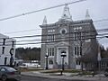
Schoharie County Courthouse
-
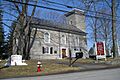
Old Stone Fort
-
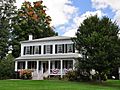
Lansing Manor House
-
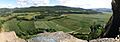
View from Vroman's Nose
-
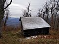
Lean-to at Huntersfield Mountain
-
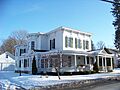
Dr. Christopher S. Best House and Office
See also
 In Spanish: Condado de Schoharie para niños
