Blenheim, New York facts for kids
Quick facts for kids
Blenheim, New York
|
|
|---|---|

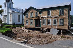
Damaged home in Blenheim after Hurricane Irene
|
|

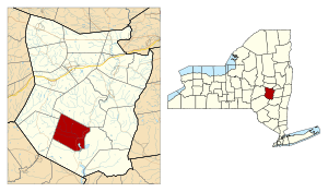
Location in Schoharie County and the state of New York.
|
|
| Country | United States |
| State | New York |
| County | Schoharie |
| Area | |
| • Total | 34.39 sq mi (89.06 km2) |
| • Land | 33.93 sq mi (87.87 km2) |
| • Water | 0.46 sq mi (1.19 km2) |
| Elevation | 1,545 ft (471 m) |
| Population
(2020)
|
|
| • Total | 308 |
| • Density | 8.956/sq mi (3.458/km2) |
| Time zone | UTC-5 (Eastern (EST)) |
| • Summer (DST) | UTC-4 (EDT) |
| FIPS code | 36-06893 |
| GNIS feature ID | 0978738 |
Blenheim is a small town located in the southwestern part of Schoharie County, New York, in the United States. It is situated to the east of Oneonta. In 2020, the town had a population of 308 people. The town got its name from a land patent, which was named after the famous Battle of Blenheim.
Contents
History of Blenheim
Blenheim was involved in some battles and attacks during the American Revolution.
The town was one of the first six towns created in Schoharie County. It was formed in 1797 from the town of Schoharie. Later, in 1803, a part of Blenheim was used to create the Town of Jefferson. Another section of Blenheim was taken in 1848 to help form the new Town of Gilboa.
Blenheim was once home to the Old Blenheim Bridge. This was one of the longest wooden covered bridges in the world, stretching 232 feet. It was built in 1855. Sadly, in 2011, the bridge was destroyed by severe flooding caused by Tropical Storm Irene.
Two important historical places in Blenheim are listed on the National Register of Historic Places. These are the Lansing Manor House and the North Blenheim Historic District.
Famous People from Blenheim
Many notable people have connections to Blenheim:
- Julia E. B. Brick – A person known for giving money to good causes.
- John A. King – A former governor of New York.
- Alonzo A. Loper – A state lawmaker from Wisconsin.
- Stephen L. Mayham – A member of the U.S. Congress.
- E. Woolsey Peck – The main judge of the Alabama Supreme Court.
Geography of Blenheim
Blenheim covers a total area of about 34.4 square miles (89.06 square kilometers). Most of this area, about 33.9 square miles (87.87 square kilometers), is land. The remaining 0.4 square miles (1.19 square kilometers) is water.
The Schoharie Creek is an important waterway that flows through the town.
New York State Route 30 is a main highway that runs north and south through the eastern part of Blenheim.
Blenheim's Population
| Historical population | |||
|---|---|---|---|
| Census | Pop. | %± | |
| 1820 | 1,826 | — | |
| 1830 | 2,280 | 24.9% | |
| 1840 | 2,725 | 19.5% | |
| 1850 | 1,314 | −51.8% | |
| 1860 | 1,367 | 4.0% | |
| 1870 | 1,437 | 5.1% | |
| 1880 | 1,191 | −17.1% | |
| 1890 | 951 | −20.2% | |
| 1900 | 768 | −19.2% | |
| 1910 | 616 | −19.8% | |
| 1920 | 516 | −16.2% | |
| 1930 | 397 | −23.1% | |
| 1940 | 415 | 4.5% | |
| 1950 | 378 | −8.9% | |
| 1960 | 345 | −8.7% | |
| 1970 | 260 | −24.6% | |
| 1980 | 292 | 12.3% | |
| 1990 | 332 | 13.7% | |
| 2000 | 330 | −0.6% | |
| 2010 | 377 | 14.2% | |
| 2020 | 308 | −18.3% | |
| U.S. Decennial Census | |||
According to the 2020 census, Blenheim had 308 residents living in 151 households. The average age of people in Blenheim was about 45.4 years. Many residents have Irish (28.1%) or German (24.0%) family backgrounds.
Communities and Places in Blenheim
Here are some of the smaller communities and locations you can find within the town of Blenheim:
- Cole Hollow – This is a valley located near the northern border of the town.
- Eminence – A small village or hamlet found on the northwestern edge of the town.
- Mine Kill State Park – A state park situated in the southeastern part of Blenheim, offering outdoor activities.
- North Blenheim – A hamlet located in the eastern part of the town, right on NY-30.
- Ruth – A hamlet found in the southwestern part of the town, along County Road 12.
See also
 In Spanish: Blenheim (Nueva York) para niños
 | Chris Smalls |
 | Fred Hampton |
 | Ralph Abernathy |

