
Gilboa, New York facts for kids
Quick facts for kids
Gilboa, New York
|
|
|---|---|

Gilboa Town Hall
|
|

Location in Schoharie County and the state of New York.
|
|
| Country | United States |
| State | New York |
| County | Schoharie |
| Area | |
| • Total | 59.38 sq mi (153.80 km2) |
| • Land | 57.81 sq mi (149.72 km2) |
| • Water | 1.58 sq mi (4.08 km2) |
| Elevation | 912 ft (278 m) |
| Population
(2020)
|
|
| • Total | 1,111 |
| Time zone | UTC-5 (Eastern (EST)) |
| • Summer (DST) | UTC-4 (EDT) |
| ZIP code |
12076
|
| Area code(s) | 607 |
| FIPS code | 36-28981 |
| GNIS feature ID | 0979001 |
Gilboa is a small town in Schoharie County, New York, United States. In 2020, about 1,111 people lived there.
The Town of Gilboa is located in the southern part of Schoharie County. It is southwest of the city of Albany.
Contents
Gilboa's History

People first started settling in the area around Gilboa in the year 1760.
The Town of Gilboa was officially created in 1848. It was formed from parts of two nearby towns: Blenheim and Broome. The name "Gilboa" comes from Mount Gilboa, a place mentioned in the Bible in Israel.
Long ago, a cotton mill in Gilboa was very important for the town's economy. However, a big flood in 1869 sadly destroyed the mill.
In 1926, the Schoharie Creek was dammed. This created the large Schoharie Reservoir. Because of this project, the original settlement of Gilboa had to be moved. A new town was built north of the reservoir.
Discovering the Ancient Fossil Forest
In 1870, workers were blasting a site for a stone quarry. They found amazing fossilized remains of tree stumps. These were very old trees!
Later, in 2004, the tops and fronds (leafy parts) of these ancient trees were also discovered. Then, in 2007, scientists announced something incredible. These fern-like trees, named Wattieza, were declared the oldest known trees on Earth! This discovery helps us understand what forests looked like millions of years ago.
Gilboa's Geography
Gilboa covers a total area of about 59.3 square miles (153.8 square kilometers). Most of this area is land, about 57.8 square miles (149.7 square kilometers). The rest is water, about 1.6 square miles (4.1 square kilometers).
The southern border of Gilboa touches Delaware County and Greene County.
The Schoharie Creek is an important waterway that flows north through the town.
Several main roads run through Gilboa. New York State Route 30 goes north and south. New York State Route 23 crosses the southwest corner of the town. There is also New York State Route 990V, which runs east from NY-30 in the southeastern part of Gilboa.
Population in Gilboa
| Historical population | |||
|---|---|---|---|
| Census | Pop. | %± | |
| 1850 | 3,024 | — | |
| 1860 | 2,541 | −16.0% | |
| 1870 | 2,227 | −12.4% | |
| 1880 | 2,040 | −8.4% | |
| 1890 | 1,718 | −15.8% | |
| 1900 | 1,448 | −15.7% | |
| 1910 | 1,467 | 1.3% | |
| 1920 | 1,541 | 5.0% | |
| 1930 | 978 | −36.5% | |
| 1940 | 1,061 | 8.5% | |
| 1950 | 943 | −11.1% | |
| 1960 | 782 | −17.1% | |
| 1970 | 854 | 9.2% | |
| 1980 | 1,078 | 26.2% | |
| 1990 | 1,207 | 12.0% | |
| 2000 | 1,215 | 0.7% | |
| 2010 | 1,307 | 7.6% | |
| 2020 | 1,111 | −15.0% | |
| U.S. Decennial Census 2020 | |||
As of the year 2020, the total population of Gilboa was 1,111 people. This means that about 1,111 people call Gilboa home.
Communities and Places in Gilboa

Gilboa has several smaller communities and interesting places:
- Blenheim-Gilboa Reservoir – A large body of water partly located in the northwestern part of Gilboa.
- Broome Center – A small community in the northeastern part of the town. It was settled around 1850.
- Five Corners – A spot south of Mackey where County Roads 17 and 18 meet.
- Flat Creek – A community in the eastern part of the town, along County Road 17.
- Gilboa – This is the main community or hamlet of Gilboa, located north of the Gilboa Reservoir.
- Gilboa-Conesville Central School – This is the only school in Gilboa, serving local students.
- Mackey – A small community found west of Broome Center.
- Mayham Pond – A small lake located north of South Gilboa Station.
- Owlsville – Another community in the northeastern section of the town.
- Schoharie Reservoir – A large reservoir that is partly in the southeastern corner of the town, just south of Gilboa village.
- South Gilboa – A community in the southwestern part of Gilboa, located on County Road 14. The historic Forks in the Road Schoolhouse and South Gilboa Railroad Station are found here.
- South Gilboa Station – A specific location in the southwestern part of the town, along NY-23.
- Upper Blenheim-Gilboa Reservoir – Another reservoir in the northwestern section of Gilboa, located east of the Blenheim-Gilboa Reservoir.
- Welch Corners – A location in the northwestern part of the town.
Images for kids
-
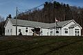
Gilboa Town Hall
-
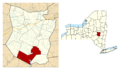
Location in Schoharie County and the state of New York.
See also
 In Spanish: Gilboa (Nueva York) para niños
