Fulton, Schoharie County, New York facts for kids
- There is a city named Fulton in Oswego County, New York as well as a Fulton County, New York.
Quick facts for kids
Fulton, New York
|
|
|---|---|

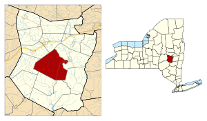
Location in Schoharie County and the state of New York.
|
|
| Country | United States |
| State | New York |
| County | Schoharie |
| Area | |
| • Total | 65.0 sq mi (168.2 km2) |
| • Land | 65.0 sq mi (168.2 km2) |
| • Water | 0.0 sq mi (0.0 km2) |
| Elevation | 1,148 ft (350 m) |
| Population
(2020)
|
|
| • Total | 1,199 |
| Time zone | UTC-5 (Eastern (EST)) |
| • Summer (DST) | UTC-4 (EDT) |
| FIPS code | 36-27826 |
| GNIS feature ID | 0978980 |
Fulton is a town in Schoharie County, New York, United States. In 2020, about 1,199 people lived there. Inside Fulton, you'll find smaller communities called hamlets, like Breakabeen and Fultonham. The town is in the middle of Schoharie County and is one of its bigger towns. Fulton is located west of Albany.
Contents
A Look at Fulton's Past
Long ago, the land where Fulton is now was home to the Mohawk tribe.
People first settled here around 1715. They bought the land directly from the local native people. Part of this early settlement was called Vroomansland, named after Adam Vrooman, who owned the land.
The town of Fulton was officially created in 1828. It was formed from a part of the Town of Middleburgh.
A special historical place called the Shafer Site was added to the National Register of Historic Places in 1980. This means it's an important place to protect and remember.
Famous People from Fulton
- William C. Bouck was a former Governor of New York. He lived on Bouck's Island in Breakabeen.
- John McGiver was a well-known Hollywood actor in the 1960s. He also lived here.
Geography and Nature
Fulton covers an area of about 65 square miles (168.2 square kilometers). All of this area is land.
The Schoharie Creek is a river that flows right through the town. Another stream, Panther Creek, flows east through the southern part of Fulton and joins the Schoharie Creek.
New York State Route 30 is a main highway that runs north and south through Fulton.
Population and People
| Historical population | |||
|---|---|---|---|
| Census | Pop. | %± | |
| 1830 | 1,592 | — | |
| 1840 | 2,147 | 34.9% | |
| 1850 | 2,566 | 19.5% | |
| 1860 | 2,914 | 13.6% | |
| 1870 | 2,700 | −7.3% | |
| 1880 | 2,683 | −0.6% | |
| 1890 | 2,316 | −13.7% | |
| 1900 | 1,998 | −13.7% | |
| 1910 | 1,450 | −27.4% | |
| 1920 | 1,227 | −15.4% | |
| 1930 | 1,010 | −17.7% | |
| 1940 | 1,010 | 0.0% | |
| 1950 | 1,050 | 4.0% | |
| 1960 | 1,008 | −4.0% | |
| 1970 | 1,060 | 5.2% | |
| 1980 | 1,394 | 31.5% | |
| 1990 | 1,514 | 8.6% | |
| 2000 | 1,495 | −1.3% | |
| 2010 | 1,442 | −3.5% | |
| 2020 | 1,199 | −16.9% | |
| U.S. Decennial Census | |||
In 2000, there were 1,495 people living in Fulton. There were 499 households, and 353 of them were families. The population density was about 23 people per square mile.
About 29.5% of households had children under 18 living with them. Many households (57.1%) were married couples living together. The average household had about 2.52 people.
The population was spread out by age. About 20.1% of the people were under 18 years old. The median age was 37 years.
Communities and Places in Fulton
- Bouck's Falls — A popular spot for relaxing.
- Bouck Hollow — A place in the southeast of Fulton, east of Schoharie Creek.
- Bouck's Island — Located on Schoharie Creek, southeast of Fultonham.
- Breakabeen — A hamlet in the southern part of the town, along NY-30. Its name comes from the German settlers and means a flat area covered with ferns.
- Fultonham — A hamlet in the southwestern part of the town on NY-30, north of Panther Creek.
- Housons Corners — A location east of Breakabeen on County Road 36.
- Max V. Shaul State Park — A state park located south of Fultonham on NY-30. It's a great place for outdoor activities.
- Patria — A hamlet near the center of the town, northwest of Fultonham.
- Vintonton — A location near the northwestern town line on County Road 4, west of Patria. It used to be called "Vintontown."
- Vroman's Nose — A famous landmark near the eastern town boundary, east of Watsonville. It's a popular hiking spot.
- Watsonville — A hamlet northeast of Fultonham on NY-30.
- West Fulton — A hamlet southwest of Fultonham, close to the southern town line. It's near the meeting point of County Roads 4 and 20. This area was once known as "Byrneville" and "Sapbush Hollow." The West Fulton Methodist Church was added to the National Register of Historic Places in 2013.
See also
 In Spanish: Fulton (condado de Schoharie, Nueva York) para niños
 | Audre Lorde |
 | John Berry Meachum |
 | Ferdinand Lee Barnett |

