Schenectady County, New York facts for kids
Quick facts for kids
Schenectady County
|
|||
|---|---|---|---|

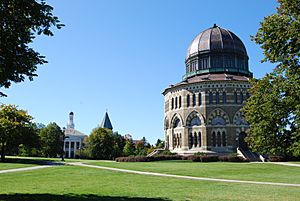
The Nott Memorial
|
|||
|
|||

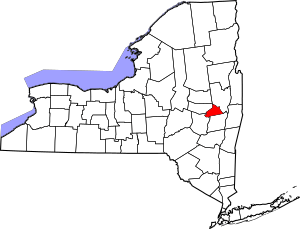
Location within the U.S. state of New York
|
|||
 New York's location within the U.S. |
|||
| Country | |||
| State | |||
| Founded | 1809 | ||
| Named for | Mohawk skahn-éht-ati, "beyond the pines" | ||
| Seat | Schenectady | ||
| Largest city | Schenectady | ||
| Area | |||
| • Total | 209 sq mi (540 km2) | ||
| • Land | 205 sq mi (530 km2) | ||
| • Water | 4.9 sq mi (13 km2) 2.3% | ||
| Population
(2020)
|
|||
| • Total | 158,061 | ||
| • Density | 772.3/sq mi (298.2/km2) | ||
| Time zone | UTC−5 (Eastern) | ||
| • Summer (DST) | UTC−4 (EDT) | ||
| Congressional district | 20th | ||
Schenectady County (pronounced skə-NEK-tə-dee) is a special area in New York State called a county. In 2020, about 158,061 people lived here. The main city and government center is Schenectady. The county's name comes from a Mohawk language word meaning "on the other side of the pine lands." This name was first used for Albany. Schenectady County is part of a larger area in New York called the Capital District.
The county is also part of the Albany-Schenectady-Troy Metropolitan Area. It is located west of where the Mohawk River meets the Hudson River. Schenectady County includes land on both the north and south sides of the Mohawk River.
Contents
A Look Back in Time
Long ago, the Mohawk people lived in this river valley. They were the easternmost group of the Iroquois Confederacy, also known as the Haudenosaunee. They grew maize (corn) in the flat lands along the Mohawk River and had villages in the nearby hills.
Early European Settlers
In the 1600s, Dutch settlers began to arrive in the area. The village of Schenectady was started in 1661. At first, people in Albany had control over the fur trade. This meant settlers in Schenectady mostly became farmers. When the English took over the Dutch colony in 1664, they also kept the fur trade monopoly for Albany.
How the County Grew
In 1683, the English organized counties in New York. The area that is now Schenectady County was part of a very large Albany County. This original Albany County was huge! It included much of northern New York, all of what is now Vermont, and even stretched west to the Pacific Ocean (at least on paper).
Over many years, Albany County became smaller as new counties were created:
- In 1766, Cumberland County was formed.
- In 1770, Gloucester County was formed. Both of these are now in Vermont.
- In 1772, Albany County was divided again, but Schenectady's area stayed within Albany.
- From 1772 to 1786, Albany County still included many areas that are now Columbia, Rensselaer, Saratoga, and Schenectady counties. It also included parts of Greene and Washington counties, plus a part of Vermont.
- More counties were split off from Albany County in 1786, 1791, 1795, and 1800.
Finally, in 1809, Schenectady County was officially created from Albany County. Its borders have stayed the same ever since. The city of Schenectady became the county seat, which is the main city where the county government is located. It is the only city in the county.
Growth and Industry
In the mid-1800s, many immigrants came to Schenectady County. Irish people arrived after the Great Famine in their home country. Later, people from Italy and Poland also came, looking for jobs in the growing industries. In the late 1800s and early 1900s, Schenectady became a very important industrial center. It was home to major companies like General Electric, which led to many new inventions.
The city of Schenectady had its largest population in 1930. However, the county as a whole reached its highest population in 1970. This shows that people started moving out of the city and into the surrounding towns and suburbs. Later in the 20th century, many jobs were lost in Schenectady due to changes in industries and railroads. Some people stayed in the county, finding other jobs or traveling to Albany for work.
Where is Schenectady County?
Schenectady County is in the east-central part of New York State. It is located northwest of Albany. This area is often called "Upstate" New York.
Size of the County
The county covers a total area of about 209 square miles (541 square kilometers). Most of this, about 205 square miles (531 square kilometers), is land. The rest, about 4.9 square miles (13 square kilometers), is water.
Neighboring Counties
Schenectady County shares its borders with these other counties:
- Saratoga County - to the northeast
- Albany County - to the southeast
- Schoharie County - to the southwest
- Montgomery County - to the west
Who Lives Here?
| Historical population | |||
|---|---|---|---|
| Census | Pop. | %± | |
| 1810 | 10,201 | — | |
| 1820 | 13,081 | 28.2% | |
| 1830 | 12,347 | −5.6% | |
| 1840 | 17,387 | 40.8% | |
| 1850 | 20,054 | 15.3% | |
| 1860 | 20,002 | −0.3% | |
| 1870 | 21,347 | 6.7% | |
| 1880 | 23,538 | 10.3% | |
| 1890 | 29,797 | 26.6% | |
| 1900 | 46,852 | 57.2% | |
| 1910 | 88,235 | 88.3% | |
| 1920 | 109,363 | 23.9% | |
| 1930 | 125,021 | 14.3% | |
| 1940 | 122,494 | −2.0% | |
| 1950 | 142,497 | 16.3% | |
| 1960 | 152,896 | 7.3% | |
| 1970 | 160,979 | 5.3% | |
| 1980 | 149,946 | −6.9% | |
| 1990 | 149,285 | −0.4% | |
| 2000 | 146,555 | −1.8% | |
| 2010 | 154,727 | 5.6% | |
| 2020 | 158,061 | 2.2% | |
| U.S. Decennial Census 1790-1960 1900-1990 1990-2000 2010-2020 |
|||
In 2010, there were 154,727 people living in Schenectady County. The population density was about 275 people per square kilometer (712 people per square mile).
People from many different backgrounds live in the county. In 2010, about 79.77% of the people were White, 9.79% were Black or African American, and 3.97% were Asian. About 6.17% of the population identified as Hispanic or Latino. Many people have Italian (24.3%), Irish (14.7%), German (8.7%), or Polish (6.4%) family roots. Most people (87.6%) speak English at home.
The population includes people of all ages. In 2010, about 24.30% of the people were under 18 years old, and 16.60% were 65 years or older. The average age was 39 years.
2020 Census Update
| Race | Num. | Perc. |
|---|---|---|
| White (NH) | 104,878 | 66.4% |
| Black or African American (NH) | 15,943 | 10.1% |
| Native American (NH) | 930 | 0.6% |
| Asian (NH) | 8,281 | 5.23% |
| Pacific Islander (NH) | 130 | 0.08% |
| Other/Mixed (NH) | 15,394 | 9.8% |
| Hispanic or Latino | 12,505 | 7.9% |
Communities in Schenectady County
Schenectady County has several towns, villages, and hamlets. Here are some of the larger communities:
Larger Settlements
| # | Location | Population | Type | Sector |
|---|---|---|---|---|
| 1 | †Schenectady | 66,135 | City | East |
| 2 | Niskayuna | 23,278 | CDP | East |
| 3 | Rotterdam | 20,652 | CDP | East |
| 4 | Scotia | 7,729 | Village | East |
| 5 | East Glenville | 6,616 | CDP | East |
| 6 | Mariaville Lake | 722 | CDP | West |
| 7 | Duanesburg | 391 | CDP | West |
| 8 | Delanson | 377 | Village | West |
| 9 | Duane Lake | 323 | CDP | West |
† - County seat
Towns
Hamlets
See also
 In Spanish: Condado de Schenectady para niños
 | George Robert Carruthers |
 | Patricia Bath |
 | Jan Ernst Matzeliger |
 | Alexander Miles |


