
Duanesburg, New York facts for kids
Quick facts for kids
Duanesburg, New York
|
|
|---|---|
| Nickname(s):
D-Burg
|
|

Location in Schenectady County and the state of New York.
|
|
| Country | United States |
| State | New York |
| County | Schenectady |
| Area | |
| • Total | 72.03 sq mi (186.56 km2) |
| • Land | 70.78 sq mi (183.33 km2) |
| • Water | 1.25 sq mi (3.23 km2) |
| Elevation | 1,280 ft (390 m) |
| Population
(2020)
|
|
| • Total | 5,863 |
| • Density | 81.397/sq mi (31.427/km2) |
| Time zone | UTC-5 (Eastern (EST)) |
| • Summer (DST) | UTC-4 (EDT) |
| ZIP code |
12056
|
| Area code(s) | 518 |
| FIPS code | 36-21006 |
| GNIS feature ID | 0978910 |
| Website | www.duanesburg.net |
Duanesburg is a small town located in Schenectady County, New York, in the United States. In 2020, about 5,863 people lived there. The town gets its name from James Duane, who owned a lot of land here a long time ago. You can find Duanesburg in the western part of Schenectady County.
Contents
History of Duanesburg
Duanesburg was first called Duanes's Bush. It officially became a town on March 13, 1765. The first people to settle here permanently were about 16 German families from Pennsylvania. They arrived in March 1765.
For a short time, Duanesburg was part of a larger area called the United Districts of Schoharie and Duanesburgh. This happened on March 24, 1772. But in 1789, Duanesburg became its own town again.
James Duane, the person the town is named after, actually hoped Duanesburg would become the capital of New York State. However, the capital was chosen to be Albany, which is only about 20 miles (32 km) away.
The earliest settlers in Duanesburg were mostly English Quakers. There were also settlers who came from the town of Kent, Connecticut.
Railroad and Farming Era
The village of Delanson, which is inside Duanesburg, was a very important stop for the Delaware and Hudson Railroad. Large amounts of coal from Pennsylvania were brought through Duanesburg. This coal was then sent northeast to cities like Albany and Boston.
East of Delanson village, there were huge piles of coal that were over 100 feet (30 m) high. Delanson village was known for being a bit rough, as it served many railroad workers. Most of the rest of Duanesburg was covered in dairy farms. Pine Grove Farms was one of the most well-known dairy farms.
Changes in the Late 20th Century
Towards the end of the 1900s, farming in Duanesburg started to decline. The town then became a place where people lived and commuted to work in nearby cities like Albany and Schenectady. Many of the old farm families saw their farms close down.
Between 1975 and 2000, many farms were divided into smaller pieces of land. Commuters built homes on lots that were often 2 acres (0.8 hectares) or larger. This area, beyond the typical suburbs, is sometimes called "exurbia". Most people living in Duanesburg traveled between 16 to 33 miles (26 to 53 km) to work each day. The completion of Interstate 88 in the early 1980s made commuting much easier. Many residents also found good jobs at General Electric during this time.
Economy and Activities
Since the year 2000, Duanesburg has seen some economic challenges. The main jobs in the region moved north of Albany, which is a harder commute from Duanesburg. Also, there isn't much affordable housing for young people, making it difficult for them to stay in the town.
Most homes are single-family houses, and there aren't many options for different types of housing. The town also has limited water for large businesses, which slows down growth. However, the town government has supported the first winery in Duanesburg, Helderberg Meadworks. It started selling its mead (a type of honey wine) in 2012 and now sells it across the state.
Because there aren't many businesses or industries, individual property taxes in Duanesburg can be higher than in surrounding areas. The town tries to keep costs low while still providing services like a school district, water systems, and maintaining 46 miles (74 km) of roads.
Fun Activities in Duanesburg
Duanesburg is known for its private airports. Skydiving has been a popular activity here for the last 30 years, bringing many visitors to the town. Jonathan's Restaurant is a well-known spot next to one of the airports.
The town is also known for cross-country skiing. In the past, places like Beardsford Farms and Oak Hill offered many miles of trails. While those are now closed, the town still has a large network of ATV trails through its beautiful woods and rural areas. Most of these trails are on private land.
During the winter, Snowmobiling is very popular. Residents use the same ATV trails to connect to other trail networks in Albany, Schoharie, and Montgomery counties.
Geography of Duanesburg
According to the United States Census Bureau, Duanesburg covers a total area of about 72.03 square miles (186.6 sq km). Of this, 70.78 square miles (183.3 sq km) is land, and 1.25 square miles (3.2 sq km), or 1.74%, is water.
The town is mostly made up of wooded hills that reach about 1,400 feet (427 m) above sea level. Most of the town was farmland until the late 1900s. Now, forests cover about 60% of the land, with trees over 40 feet (12 m) tall. These forests have trees like poplar, hemlock, oak, maple, white pine, and balsam fir. The tallest trees in Duanesburg are about 80 feet (24 m) high.
Duanesburg is where the Normans Kill and Bozenkill Creek begin. These creeks flow over many rapids and waterfalls, cutting through shale and sandstone rocks. Christman's Sanctuary is a good place to see this natural beauty.
Most of the soil in Duanesburg contains clay, loose rocks, or is shallow. This means it's not very good for large-scale farming. There are also many swamps in the town, both at high and low elevations. This is due to the clay soil and what was left behind by glaciers long ago.
The town is special because of its east-west oriented drumlins. Drumlins are oval-shaped hills made of glacial sediment. Most drumlins in New York State point north-south, so Duanesburg's are unique.
Because of its higher elevation, Duanesburg offers amazing views that can reach as far as southern Vermont, the Adirondack Mountains, and the Catskill Mountains.
Major roads like US 20, NY 7, and Interstate 88 all pass through the town.
The southern part of Duanesburg borders Albany County. The rest of the southern border and part of the western border is with Schoharie County. The rest of the western border and part of the northern border is with Montgomery County.
Population Information
| Historical population | |||
|---|---|---|---|
| Census | Pop. | %± | |
| 1820 | 3,510 | — | |
| 1830 | 2,837 | −19.2% | |
| 1840 | 3,357 | 18.3% | |
| 1850 | 3,464 | 3.2% | |
| 1860 | 3,222 | −7.0% | |
| 1870 | 3,042 | −5.6% | |
| 1880 | 2,995 | −1.5% | |
| 1890 | 2,557 | −14.6% | |
| 1900 | 2,428 | −5.0% | |
| 1910 | 2,211 | −8.9% | |
| 1920 | 2,115 | −4.3% | |
| 1930 | 1,937 | −8.4% | |
| 1940 | 2,141 | 10.5% | |
| 1950 | 2,822 | 31.8% | |
| 1960 | 3,070 | 8.8% | |
| 1970 | 3,800 | 23.8% | |
| 1980 | 4,729 | 24.4% | |
| 1990 | 5,474 | 15.8% | |
| 2000 | 5,808 | 6.1% | |
| 2010 | 6,122 | 5.4% | |
| 2020 | 5,863 | −4.2% | |
| U.S. Decennial Census | |||
In the year 2000, there were 5,808 people living in Duanesburg. These people made up 2,141 households, and 1,663 families. The town had about 81.5 people per square mile (31.5 people per sq km). There were 2,307 homes in total.
Most of the people in Duanesburg were White (97.66%). A smaller number were African American (0.45%), Native American (0.29%), or Asian (0.28%). About 0.81% of the population was Hispanic or Latino.
In terms of age, 26.9% of the population was under 18 years old. About 30.4% were between 25 and 44 years old. The average age in the town was 38 years. For every 100 females, there were about 101 males.
The average income for a household in Duanesburg was $58,463. For families, the average income was $65,461.
Places and Communities in Duanesburg
Duanesburg has several smaller communities and interesting locations within its borders:
- Braman Corners – A small community in the western part of town. It is named after Joseph Braman. The Joseph Braman House is located here.
- Millers Corners – Another small community in the northwestern part of town.
- Delanson – This is a village located in the southeastern part of Duanesburg.
- Duane – A small community found south of the main Duanesburg hamlet.
- Duanesburg – This is the main hamlet (a small settlement) in the southern part of the town.
- Duanesburg Churches – A specific location just north of the Duanesburg hamlet.
- Duane Lake – A community near a small, man-made lake called Duane Lake. This lake is southeast of the Duanesburg village.
- Eaton Corners – A location in the western part of the town.
- Mariaville – A community located close to the northeastern border of the town.
- Mariaville Lake – A community near a small lake also called Mariaville Lake, which is near the eastern town line.
- Quaker Street – A community in the southwestern part of the town. A large part of this community is part of the Quaker Street Historic District. This district was added to the National Register of Historic Places in 1984.
Famous People from Duanesburg
- Lisa Barlow – A cast member from the TV show "The Real Housewives of Salt Lake City."
- Isabelle Bronk (1858–1943) – She was the head of the romance languages department at Swarthmore College from 1901 to 1927.
- Blackleach Burritt – A well-known clergyman during the American Revolution.
- Charles A. Cady – A Wisconsin State Assemblyman.
- Orestes Cleveland (1829–1896) – He was the mayor of Jersey City several times and also represented New Jersey in the U.S. House of Representatives.
- Stephen J. Dubner – He is the co-author of the famous book Freakonomics.
- Nick Gwiazdowski – A freestyle wrestler who won two national championships in NCAA Division I Wrestling for North Carolina State University.
- Emma White – An American cyclist.
Images for kids
-
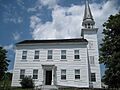
Christ Episcopal Church, June 2009
-
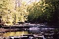
Normanskill Creek in Duanesburg


See also
 In Spanish: Duanesburg para niños
