Kent, Connecticut facts for kids
Quick facts for kids
Kent, Connecticut
|
||
|---|---|---|
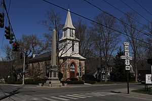
St. Andrew's Church
|
||
|
||
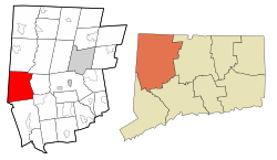 Litchfield County and Connecticut Litchfield County and Connecticut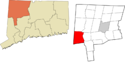 Northwest Hills Planning Region and Connecticut Northwest Hills Planning Region and Connecticut |
||
| Country | United States | |
| U.S. state | Connecticut | |
| County | Litchfield | |
| Region | Northwest Hills | |
| Incorporated | 1739 | |
| Named for | Kent, England | |
| Government | ||
| • Type | Selectman-town meeting | |
| Area | ||
| • Total | 49.6 sq mi (128.5 km2) | |
| • Land | 48.5 sq mi (125.7 km2) | |
| • Water | 1.0 sq mi (2.7 km2) | |
| Elevation | 466 ft (142 m) | |
| Population
(2020)
|
||
| • Total | 3,019 | |
| • Density | 60/sq mi (24/km2) | |
| Time zone | UTC-5 (Eastern) | |
| • Summer (DST) | UTC-4 (Eastern) | |
| ZIP codes |
06757, 06785
|
|
| Area code(s) | 860/959 | |
| FIPS code | 09-40290 | |
| GNIS feature ID | 0213446 | |
Kent is a town in Litchfield County, Connecticut, located in the United States. It's right next to the border with New York. In 2020, about 3,019 people lived here. Kent is part of the Northwest Hills Planning Region.
Kent is known for its three boarding schools: Kent School, the Marvelwood School, and South Kent School. The Schaghticoke Indian Reservation is also found within the town's borders. Some famous people have lived in Kent, including former U.S. Secretary of State Henry Kissinger and Family Guy creator Seth MacFarlane.
Contents
History of Kent
The town of Kent was first planned out in 1737. People started settling there around 1739. The town was named after Kent, a county in England.
Geography of Kent
Kent is in the western part of Litchfield County. It shares a border with Dutchess County, New York to the west. The town is about 26 miles (42 kilometers) north of Danbury and 50 miles (80 km) west of Hartford. The main village of Kent is located at 41°43′29″N 73°28′39″W / 41.72472°N 73.47750°W.
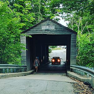
The town covers a total area of 49+5⁄8 square miles (128.5 km2). Most of this is land (48+1⁄2 square miles (125.7 km2)), with a small part being water (1 square mile (2.7 km2), or 2.14%). Bull's Bridge, one of only two covered bridges in Connecticut that vehicles can still use, is in Kent. The Housatonic River flows right through the middle of the town. The western side of Kent includes Macedonia Brook State Park, the Schaghticoke Indian Reservation, and a part of the famous Appalachian Trail.
Main Communities in Kent
Kent has several smaller communities within its borders:
- Bulls Bridge
- Flanders
- Kent center
- Kent Furnace
- Macedonia
- North Kent
- South Kent (which has its own post office)
- Schaghticoke Indian Reservation
Places to Visit in Kent
Macedonia Brook State Park
Macedonia Brook State Park opened in 1918. It started with 1,552 acres (628 hectares) of land donated by the White Memorial Foundation. Today, the park has grown to 2,300 acres (930 ha). It's a popular spot for outdoor activities all year round.
The park is known for its beautiful views of the Appalachia region. It also has many trails for hiking, campgrounds, and places for large group picnics. There's a small lake on a hilltop and the park's namesake, Macedonia Brook. Visitors can use the grills set up for cooking. From the peaks on the Blue Trail, hikers can see the Catskill Mountains and the Taconic Mountains.
Kent Falls State Park
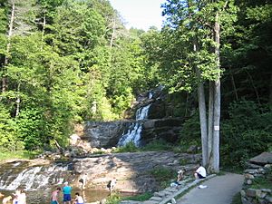
Kent Falls State Park is often called "The Jewel of the Inland Parks" because of its 17 beautiful waterfalls. The water for the falls comes from wetlands in Warren. It then flows into the Housatonic River, which is just across the highway from the park.
A trail goes up along the falls for about a quarter of a mile. It's a bit steep, rising 250 feet (80 meters) in that short distance. In 2006, the trail was improved with new viewing platforms. Swimming used to be allowed along the falls. However, due to accidents and damage to nature, swimming is now not allowed in most areas by state law.
The park is a special "Trout Park." This means it's stocked with trout fish from state hatcheries. Because it's a Trout Park, you can only catch two fish per day.
Bulls Bridge
Bull's Bridge is one of only three covered bridges in Connecticut that are still standing from the 1800s. George Washington himself crossed the Housatonic River near where this bridge is now, back in 1781. The bridge was built in 1842 by architect Ithiel Town. It's a single-lane bridge with a special lattice truss design.
Sloane-Stanley Museum
This museum shows off the art studio and old collections of Eric Sloane, a famous artist and author.
Connecticut Antique Machinery Association
This is a museum that works to save and fix old machines. They also teach people about Connecticut's history in factories and farming. A cool part of the museum is its 3 ft (914 mm) narrow-gauge railroad. It even has a working steam train!
Population of Kent
| Historical population | |||
|---|---|---|---|
| Census | Pop. | %± | |
| 1820 | 1,956 | — | |
| 1850 | 1,848 | — | |
| 1860 | 1,855 | 0.4% | |
| 1870 | 1,744 | −6.0% | |
| 1880 | 1,622 | −7.0% | |
| 1890 | 1,383 | −14.7% | |
| 1900 | 1,220 | −11.8% | |
| 1910 | 1,122 | −8.0% | |
| 1920 | 1,086 | −3.2% | |
| 1930 | 1,054 | −2.9% | |
| 1940 | 1,245 | 18.1% | |
| 1950 | 1,392 | 11.8% | |
| 1960 | 1,686 | 21.1% | |
| 1970 | 1,990 | 18.0% | |
| 1980 | 2,505 | 25.9% | |
| 1990 | 2,918 | 16.5% | |
| 2000 | 2,858 | −2.1% | |
| 2010 | 2,979 | 4.2% | |
| 2020 | 3,019 | 1.3% | |
| U.S. Decennial Census | |||
In 2000, there were 2,858 people living in Kent. About 28.6% of households had children under 18. The average household had 2.43 people. The average family had 2.99 people.
The population was spread out by age:
- 22.8% were under 18 years old.
- 5.2% were between 18 and 24.
- 26.3% were between 25 and 44.
- 27.8% were between 45 and 64.
- 17.8% were 65 years or older.
The median age in Kent was 43 years. For every 100 females, there were about 93.9 males.
Education in Kent
Kent is part of Regional School District 01. This district also includes the towns of Canaan, Cornwall, North Canaan, Salisbury, and Sharon.
Students in public schools attend Kent Center School for grades K–8. They then go to Housatonic Valley Regional High School for grades 9–12.
Kent also has three private schools:
- Kent School: A school for both boys and girls, connected to the Episcopal Church. It serves grades 9–12 and postgraduate students.
- South Kent School: An Episcopal school just for boys.
- Marvelwood School: A school for both boys and girls that is not connected to any religion.
Transportation in Kent
U.S. Route 7 is the main road that goes north and south through Kent. Connecticut Route 341 is the main road that goes east and west. Route 7 goes north 25 miles (40 km) to North Canaan and south 28 miles (45 km) to Danbury. Route 341 goes east 8 miles (13 km) to Warren and west to the New York border and the town of Amenia.
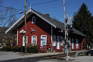
The Kent train station used to have passenger trains. These trains ran between New York City and Pittsfield until 1974. Now, the train line is only used for freight (cargo) trains run by the Housatonic Railroad. The closest train stations for passengers today are Harlem Valley–Wingdale station and Dover Plains station. These are on Metro-North Railroad's Harlem Line.
The Northwestern Connecticut Transit District (NWCTD) offers a special bus service called "dial-a-ride." This service is available in Kent and nearby towns.
Notable People from Kent
Many interesting people have lived in or are from Kent:
- William H. Armstrong, author of Sounder
- Joe Bouchard, a founding member of the band Blue Öyster Cult
- Ted Danson, actor
- Lana Del Rey, singer
- Brendan Fraser, actor
- Clinton Kelly, television host
- Henry Kissinger, former U.S. Secretary of State
- Trudie Lamb-Richmond, a Schaghticoke elder, activist, author, and educator
- Patti LuPone, singer and actress
- Seth MacFarlane, creator of Family Guy and other TV shows
See also
 In Spanish: Kent (Connecticut) para niños
 | John T. Biggers |
 | Thomas Blackshear |
 | Mark Bradford |
 | Beverly Buchanan |


