
Salisbury, Connecticut facts for kids
Quick facts for kids
Salisbury, Connecticut
|
||
|---|---|---|
| Town of Salisbury | ||

Salisbury Town Hall
|
||
|
||
 Litchfield County and Connecticut Litchfield County and Connecticut Northwest Hills Planning Region and Connecticut Northwest Hills Planning Region and Connecticut |
||
| Country | ||
| U.S. state | ||
| County | Litchfield | |
| Region | Northwest Hills | |
| Established / Incorporated | 1741 | |
| Government | ||
| • Type | Selectman-town meeting | |
| Area | ||
| • Total | 60.1 sq mi (155.6 km2) | |
| • Land | 57.3 sq mi (148.3 km2) | |
| • Water | 2.8 sq mi (7.3 km2) | |
| Elevation | 699 ft (213 m) | |
| Population
(2020)
|
||
| • Total | 4,194 | |
| • Density | 69.810/sq mi (26.954/km2) | |
| Time zone | UTC-5 (Eastern) | |
| • Summer (DST) | UTC-4 (Eastern) | |
| ZIP codes |
06039, 06068 06079
|
|
| Area code(s) | 860/959 | |
| FIPS code | 09-66420 | |
| GNIS feature ID | 0213500 | |

Salisbury (say "SAWLZ-berry") is a town in Litchfield County, Connecticut, United States. It's located in the very northwest corner of Connecticut. This means it's the last town in the state before you reach Massachusetts and New York.
A special spot in Salisbury is where Connecticut, Massachusetts, and New York all meet. This is called a tri-state marker. In 2020, about 4,194 people lived in Salisbury. The town is part of the Northwest Hills Planning Region.
Contents
History of Salisbury
Salisbury was officially started in 1741. It has many old houses, though some have been replaced by newer ones. The town was named after Salisbury, a city in England.
The Iron Industry in Salisbury
In 1728, people found traces of iron in the area that would become Salisbury. A bigger discovery was made in 1731 by John Pell and Ezekiel Ashley. This led to Salisbury becoming a very important center for making iron. This iron industry was active from before the American Revolutionary War until around 1920.

More iron mines opened, mostly in the western part of town. The iron made in Salisbury was known for being very high quality. It was even used to make gun barrels! This special iron was also used for cast-iron railroad car wheels.
However, the quality of Salisbury iron could sometimes vary. The iron industry in Salisbury stopped after World War I. There was a plan to restart it during World War II, but it never happened. Today, the old mines are still underwater.
Historic Firsts in Salisbury
Salisbury is home to the Scoville Library. This was the first library in the United States that was open to the public for free.
The town also has the oldest Methodist church in New England. This church, called the Lakeville Methodist Church, was built in 1789.

Geography of Salisbury
Salisbury is in the northwest corner of Litchfield County and the state of Connecticut. To the north, it shares a border with Berkshire County, Massachusetts. To the west, it borders Dutchess County, New York.
Salisbury is about 49 miles (79 km) northwest of Hartford, which is Connecticut's capital. It's also 38 miles (61 km) south of Pittsfield, Massachusetts, and 39 miles (63 km) northeast of Poughkeepsie, New York.
Land and Water Features
The town covers a total area of about 60 square miles (155.6 sq km). Most of this is land, about 57.3 square miles (148.3 sq km). The rest, about 2.8 square miles (7.3 sq km), is water.
Salisbury has several ponds and six lakes. These include Lake Wononscopomuc, Washinee, Washining, Wononpakook, Riga Lake, and South Pond. The Housatonic River forms the eastern edge of the town.
Highest Point in Connecticut
While the very top of Mount Frissell is in Massachusetts, the southern slope of the mountain is in Salisbury. This part of Mount Frissell is the highest point in Connecticut. It reaches an elevation of 2,380 feet (725 m).
Communities within Salisbury
The town of Salisbury includes several smaller communities. One of these is Lakeville. There are also hamlets (small villages) like Amesville, Lime Rock, Salisbury, and Taconic. Taconic used to be called Chapinville.
Taconic is in the northern part of Salisbury. It's a seasonal community, meaning many people only live there during certain times of the year. It has about 200 residents, a town green, and a post office.
Population and People

In 2000, there were 3,977 people living in Salisbury. These people lived in 1,737 households, and 1,042 of these were families. The population density was about 69.4 people per square mile (26.8 per sq km).
Most of the people in Salisbury were White (95.75%). There were also smaller groups of African American (1.66%), Native American (0.33%), and Asian (0.96%) residents. About 1.53% of the population was Hispanic or Latino.
The average household had 2.19 people, and the average family had 2.81 people. About 25.5% of households had children under 18 living with them.
The median age in Salisbury was 47 years old. This means half the people were older than 47 and half were younger. About 22.4% of the population was under 18. About 21.6% were 65 years or older.
The median income for a household in Salisbury was $53,051. For a family, the median income was $69,152. About 7.8% of the population lived below the poverty line. This included 7.6% of those under 18.
Parks and Outdoor Activities
Salisbury offers many outdoor activities. The famous Appalachian Trail passes through the town. Mount Riga State Park is also located in Salisbury.
Sports in Salisbury
The Salisbury Winter Sports Association holds exciting ski jumping competitions. These events take place at their Satre Hill venue in Salisbury. They have hosted the United States Eastern Ski Jumping Championships every February since 1952.
Another well-known sports venue is Lime Rock Park. This is a famous automobile racing course located in the southeast part of Salisbury.
Education in Salisbury
Salisbury is part of Regional School District 01. This district also includes the nearby towns of Canaan, Cornwall, Kent, North Canaan, and Sharon.
Public school students in Salisbury attend Salisbury Central School for grades K-8. For high school, they go to Housatonic Valley Regional High School in Falls Village.
Salisbury is also home to three boarding schools. These are Salisbury School and Hotchkiss School, both high schools, and Indian Mountain School, which serves Pre-K through grade 9.
Local News and Information
The community of Salisbury is served by a weekly newspaper called The Lakeville Journal. There is also a daily newspaper, the Republican-American, which is based in Waterbury.
The Salisbury Sampler is a newsletter published 10 times a year. It shares community events, notices, and news. The Salisbury Association also publishes a newsletter twice a year. It covers news and activities from the land trust, historical, and civic groups. Both newsletters are mailed to all homes in Salisbury.
Transportation in Salisbury
Main Roads
U.S. Route 44 is the main road that runs east-west through Salisbury. Connecticut Route 41 is the main road that runs north-south.
US 44 goes northeast about 7 miles (11 km) to North Canaan. It goes southwest about 6 miles (10 km) to Millerton, New York. Route 41 goes south about 8 miles (13 km) to Sharon. It goes north about 17 miles (27 km) to Great Barrington, Massachusetts.
Connecticut Route 112 runs diagonally, from northwest to southeast. It connects with U.S. Route 7. Route 7 runs north-south, parallel to the Housatonic River.
Notable People from Salisbury
Many interesting people have lived in or been connected to Salisbury.

- Ethan Allen (1738–1789), who owned an iron furnace in Lakeville.
- Charles B. Andrews (1834–1902), a former Governor of Connecticut.
- William Henry Barnum (1818–1889), a congressman and US senator.
- Daniel Chipman (1765–1850), a congressman from Vermont.
- Nathaniel Chipman (1752–1843), a US senator from Vermont.
- Martin Chittenden (1763–1840), the seventh governor of Vermont, born in Salisbury.
- Thomas Chittenden (1730–1797), the first governor of Vermont.
- Jill Clayburgh (1944–2010), an actress nominated for an Academy Award; she lived and died in Lakeville.
- Jeff Greenfield (born 1943), a television journalist.
- Margaret Hamilton (1902–1985), the actress who played the Wicked Witch of the West in The Wizard of Oz; she spent her last years in town.
- Edward Herrmann (1943–2014), an Emmy Award-winning actor.
- Maria Bissell Hotchkiss (1827–1901), who founded Hotchkiss School in Lakeville.
- Alfred Korzybski (1879–1950), who founded the Institute of General Semantics in Lime Rock.
- Richmond Landon (1898–1971), an Olympic gold medal winner.
- Wanda Landowska (1879–1959), a famous harpsichordist; she lived in Lakeville.
- Laura Linney (born 1964), an Emmy and Golden Globe award-winning actress.
- Frederick Miles (1815–1896), a congressman from Connecticut.
- Peter Buell Porter (1773–1844), a U.S. Secretary of War; born in town.
- Joseph Schumpeter (1883–1950), an economist; he died in Taconic.
- Jonathan Scoville (1830–1891), a congressman.
- Roy Sherwood (1932–2017), a ski jumper who competed in the 1956 Olympics.
- Georges Simenon (1903–1989), a Belgian author known for his Maigret novels; he lived in Lakeville.
- Meryl Streep (born 1949), a multiple Oscar-winning actress; she lives in Salisbury with her family.
- Rip Torn (1931–2019), an Emmy Award-winning and Oscar-nominated actor.
- Elisha Whittlesey (1783–1863), a congressman.
Images for kids
-
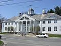
Salisbury Town Hall
-
Salisbury Town Seal
-
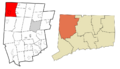
Salisbury's location within Litchfield County and Connecticut
-
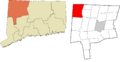
Salisbury's location within the Northwest Hills Planning Region and the state of Connecticut
-
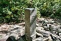
The CT-MA-NY tri-state marker on the border of Salisbury
See also
 In Spanish: Salisbury (Connecticut) para niños
