
Litchfield County, Connecticut facts for kids
Quick facts for kids
Litchfield County
|
|
|---|---|

|
|

Location within the U.S. state of Connecticut
|
|
 Connecticut's location within the U.S. |
|
| Country | |
| State | |
| Founded | 1751 |
| Named for | Lichfield, England |
| Seat | none (since 1960) Litchfield (before 1960) |
| Largest city | Torrington (by population) New Milford (by area) |
| Area | |
| • Total | 945 sq mi (2,450 km2) |
| • Land | 921 sq mi (2,390 km2) |
| • Water | 24 sq mi (60 km2) 2.5%% |
| Population
(2020)
|
|
| • Total | 185,186 |
| • Density | 196.0/sq mi (75.7/km2) |
| Time zone | UTC−5 (Eastern) |
| • Summer (DST) | UTC−4 (EDT) |
| Congressional districts | 1st, 5th |
Litchfield County is a county located in the northwestern part of Connecticut, United States. In 2020, about 185,186 people lived here. The county got its name from Lichfield, a city in England. Litchfield County is the largest county in Connecticut by land area. It also has the fewest people per square mile compared to other counties in the state.
Litchfield County is part of the Torrington, CT, Micropolitan Statistical Area. This area is also included in the larger New York–Newark–CT–PA Combined Statistical Area.
Like other counties in Connecticut, Litchfield County does not have its own county government or a county seat (a main city for government). Since 1960, each town in the county is in charge of its own local services. These services include schools, snow removal, sewers, and police and fire departments. Sometimes, nearby towns work together to provide services or even create a regional school system. In 2022, the U.S. Census Bureau started recognizing Connecticut's nine councils of governments as county equivalents. This is because the old county governments were stopped in 1960, and these councils took over some of their jobs.
Contents
History of Litchfield County
Litchfield County was officially created on October 9, 1751. It was formed from parts of three other counties: Fairfield, New Haven, and Hartford counties. The original act that created the county said that several towns in the northwestern part of the colony would become one county called Litchfield. This new county would have the same rights and rules as other counties in the colony. Its borders would reach north and west to the colony lines.
Over the years, between 1780 and 1807, some towns moved in or out of Litchfield County. For example, the town of Watertown was added in 1780. Later, some areas were transferred to other counties like Fairfield, Hartford, and New Haven counties. The last border change happened in 1807 when the town of Middlebury was created from part of Woodbury.
During the American Civil War in 1862, Litchfield County helped by forming the 2nd Connecticut Heavy Artillery Regiment. This group of soldiers first defended Washington, D.C. Then, they joined the main Union army, the Army of the Potomac. In June 1864, they fought in the Battle of Cold Harbor and suffered heavy losses. The regiment continued to fight until the war ended in 1865.
Geography and Natural Features
Litchfield County covers a total area of 945 square miles. About 921 square miles is land, and 24 square miles (2.5%) is water. This makes it the largest county in Connecticut by land area. The county is mostly located in the Appalachian Mountains range. This part of the Appalachians is often called the Berkshire Mountains or, locally, the Litchfield Hills.
Neighboring Counties
Litchfield County shares borders with several other counties:
- Berkshire County, Massachusetts (to the north)
- Hampden County, Massachusetts (to the northeast)
- Hartford County (to the east)
- New Haven County (to the southeast)
- Fairfield County (to the south)
- Dutchess County, New York (to the west)
Population and People
The population of Litchfield County has changed a lot over the years. In 1790, there were about 38,635 people. By 2020, the population had grown to 185,186.
According to the 2010 census, there were 189,927 people living in the county. Most people (93.9%) were white. Other groups included Asian (1.5%), Black or African American (1.3%), and American Indian (0.2%). About 4.5% of the population was of Hispanic or Latino origin. Many residents had Italian, Irish, English, or German backgrounds.
There were 76,640 households in the county. About 29.9% of these households had children under 18 living with them. The average household had 2.44 people. The median age in the county was 44.4 years old. The median income for a household was about $69,639, and for a family, it was $84,890. About 5.8% of all people in the county lived below the poverty line.
Transportation and Travel
Litchfield County is served by the Northwestern Connecticut Transit District, which helps people get around.
Towns and Communities


In Litchfield County, there are different types of communities:
- Boroughs are parts of towns that have their own separate local governments, like borough councils.
- Villages are named places, but they don't have their own separate governments; they are part of the town they are in.
Main City
Towns in Litchfield County
- Barkhamsted (includes Pleasant Valley and Riverton)
- Bethlehem (includes Bethlehem Village)
- Bridgewater
- Canaan (includes Falls Village)
- Colebrook
- Cornwall (includes Cornwall, Cornwall Bridge, and West Cornwall)
- Goshen (includes West Goshen)
- Harwinton (includes Northwest Harwinton)
- Kent (includes Flanders and South Kent)
- Litchfield (includes Bantam, East Litchfield, and Northfield)
- Morris
- New Hartford (includes New Hartford Center and Pine Meadow)
- New Milford (includes Chimney Point, Downtown New Milford, Erickson Corner, Gaylordsville, Merryall, and Northville)
- Norfolk
- North Canaan
- Plymouth (includes East Plymouth and Terryville)
- Roxbury
- Salisbury (includes Lakeville and Lime Rock)
- Sharon (includes Sharon and Sharon Valley)
- Thomaston
- Warren
- Washington (includes New Preston)
- Watertown (includes Oakville)
- Winchester (includes Winsted)
- Woodbury (includes Hotchkissville and Woodbury Center)
Telephone Area Codes
Most of Litchfield County uses the area code 860. However, the towns of Woodbury, Bethlehem, and a small part of Roxbury use the area code 203/area code 475 overlay. This means you need to dial ten digits (area code + number) for all calls in these areas.
Fun Places to Visit
Litchfield County has many interesting places to explore:
- Abbey of Regina Laudis
- Appalachian Trail in Connecticut (a famous hiking trail)
- Bash Bish Falls State Park (a beautiful waterfall park, nearby in Massachusetts)
- Kent Falls State Park
- Litchfield Historic District (a historic area with old buildings)
- Mohawk Mountain Ski Area (a place for skiing)
- West Cornwall Covered Bridge (a historic covered bridge)
Education and Schools
School districts in Litchfield County usually follow the boundaries of the towns.
Schools for All Grades (K-12)
- Litchfield School District
- New Milford School District
- Plymouth School District
- Regional School District 06
- Regional School District 10
- Regional School District 12
- Regional School District 14
- Thomaston School District
- Torrington School District
- Watertown School District
- Winchester School District
High School Districts
- Regional High School District 01
- Regional High School District 07
- The Gilbert School is a privately funded public high school.
Elementary School Districts
- Barkhamsted School District
- Canaan School District
- Colebrook School District
- Cornwall School District
- Kent School District
- New Hartford School District
- Norfolk School District
- North Canaan School District
- Salisbury School District
- Sharon School District
Private Schools
Litchfield County is home to several well-known private schools, many of which are boarding schools where students live at the school.
Boarding Schools
- Canterbury School (New Milford, founded 1915)
- Forman School (Litchfield, founded 1930)
- The Gunnery (Washington, founded 1850)
- Hotchkiss School (Lakeville, founded 1892)
- Kent School (Kent, founded 1906)
- Marvelwood School (Kent, founded 1956)
- Salisbury School (Salisbury, founded 1901)
- South Kent School (Kent, founded 1923)
- Taft School (Watertown, founded 1890)
- The Woodhall School (Bethlehem, founded 1983)
Schools for Younger Students with Special Needs
- Glenholme School (Washington, founded 1968) for ages 10–21.
- Indian Mountain School (Lakeville, founded 1916) for ages 10–15.
- Rumsey Hall School (Washington, founded 1900) for ages 10–15.
Private Day Schools
These schools are for students who live at home and attend school during the day.
- Arch Bridge School (Bethlehem, grades 3-12)
- Faith Preparatory School (New Milford, grades K-12)
- Litchfield Montessori School (Northfield, grades K-8)
- St. Anthony School (Winsted, grades K-8)
- St. John Evangelist School (Watertown, grades K-8)
- St. Mary Magdalen School (Oakville, grades K-8)
- St. Peter/St. Francis School (Torrington, grades K-8)
- Torrington Christian Academy (Torrington, grades K-12)
- Touchstone School (Litchfield, grades 9-11)
- Washington Montessori School (New Preston, grades K-8)
Images for kids
-
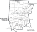
Map of Litchfield County, Connecticut showing cities, boroughs, towns, CDPs, and Indian Reservations
-
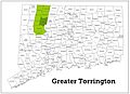
Map highlighting the Greater Torrington Micropolitan Area
See also
 In Spanish: Condado de Litchfield para niños
