
West Cornwall Covered Bridge facts for kids
Quick facts for kids West Cornwall Covered Bridge |
|
|---|---|
The West Cornwall Covered Bridge, crossing the Housatonic River
|
|
| Coordinates | 41°52′18″N 73°21′52″W / 41.87167°N 73.36444°W |
|
West Cornwall Bridge
|
|

Location in Connecticut

Location in the United States
|
|
| Area | 1 acre (0.4 ha) |
| NRHP reference No. | 75001923 |
| Added to NRHP | December 30, 1975 |
| Carries | Sharon-Goshen Turnpike (Connecticut Route 128) |
| Crosses | Housatonic River |
| Locale | Cornwall, Connecticut |
| Maintained by | State of Connecticut |
| Characteristics | |
| Design | Town lattice truss bridge |
| Material | wood |
| Total length | 172 feet (52.4 m) |
| Width | 15 feet (4.6 m) |
| Number of spans | 2 |
| Piers in water | 1 |
| History | |
| Opened | Circa 1864 |
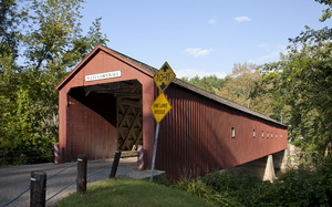
The West Cornwall Covered Bridge is a special wooden bridge in Cornwall, Connecticut. It carries the Sharon-Goshen Turnpike over the Housatonic River. This bridge is known for its unique design, called a lattice truss bridge. It has been around for a long time, with the current version finished around 1864.
Even though it's old, the bridge has been updated over the years to handle modern traffic. It was added to the National Register of Historic Places in 1975. This means it's an important historical site worth protecting.
Contents
How Old is the West Cornwall Bridge?
Many bridges have stood at this spot in Cornwall, Connecticut. Records show that a bridge might have been here as early as 1762. But these early bridges didn't last long. Floods and ice often destroyed them. One author, Peter Vermilyea, says that wooden bridges back then usually lasted only seven to ten years.
A bridge built in 1841 replaced an older one that was washed away by a flood in 1837. For many years, people thought the current bridge was that 1841 one. However, new research shows that the bridge we see today was actually finished around 1864. It likely reused the strong center support from the older bridge.
Saving the Bridge
In 1968, the State of Connecticut thought about replacing the bridge. But people in West Cornwall wanted to save their historic covered bridge. They formed a group and worked hard to convince the Connecticut Department of Transportation to fix it instead.
Thanks to their efforts, the bridge was renovated. It was raised two feet higher, and strong steel supports were added underneath. In 1973, the road itself was made even stronger with a hidden steel deck. This project was so well done that it won an award for historic preservation!
Surviving Disasters
The West Cornwall Covered Bridge has faced many challenges over the years. It survived big floods in 1938 and 1955. These floods were caused by hurricanes, but the bridge held strong.
In 1961, a huge ice jam threatened to destroy it. Luckily, the jam was safely removed using dynamite. The bridge also needed repairs in 1945 after a large oil truck broke through its floor. Despite all these events, the bridge continues to stand.
What Does the West Cornwall Bridge Look Like?
The West Cornwall Covered Bridge is about 172 feet (52 m) long and 15 feet (4.6 m) wide. It has one lane for cars on the Sharon-Goshen Turnpike (Connecticut Route 128). The main part of the bridge, called a Town lattice truss, is made from red-spruce wood. These pieces are held together with wooden pegs called treenails.
Later, another type of support, called a queen-post truss, was added. This was probably done to make the bridge stiffer, as wooden bridges can sometimes sag over time. Before 1946, the bridge had a flat roof. But now it has a pointed gable roof, which was added then. In 1957, the bridge was painted red for the first time.
Unique Design Features
The bridge actually has two sections, or spans, that are different lengths. There's a small gap between them. The way the original Town lattice design combines with the later queen trusses makes the bridge look very unique. It's not a common design to see.
Since 1973, when steel supports were added under the road, the wooden trusses mostly support themselves. The bridge is still in good condition, according to inspections.
Why is the West Cornwall Bridge Important?

The West Cornwall Covered Bridge is very important because it's one of only three covered bridges left in the entire state of Connecticut. Its special design, with the added queen trusses, makes it different from the other two covered bridges in the state, Comstock's Bridge and Bull's Bridge.
The bridge is also famous for appearing on postcards of New England villages. Some people believe that the composer Charles Ives was inspired by this bridge for one of his famous musical pieces, Three Places in New England. The bridge even appeared in the opening scenes of the 1967 movie Valley of the Dolls.
The bridge was officially recognized for its historical value when it was listed on the National Register of Historic Places in 1975.
Images for kids
-
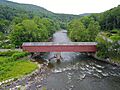
Aerial view of the bridge.
.jpg)
