
Goshen, Connecticut facts for kids
Quick facts for kids
Goshen, Connecticut
|
||
|---|---|---|
| Town of Goshen | ||

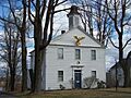
Goshen Academy building
|
||
|
||
 Litchfield County and Connecticut Litchfield County and Connecticut Northwest Hills Planning Region and Connecticut Northwest Hills Planning Region and Connecticut |
||
| Country | ||
| U.S. state | ||
| County | Litchfield | |
| Region | Northwest Hills | |
| Incorporated | 1739 | |
| Government | ||
| • Type | Selectman-town meeting | |
| Area | ||
| • Total | 45.2 sq mi (117.0 km2) | |
| • Land | 43.6 sq mi (113.0 km2) | |
| • Water | 1.5 sq mi (4.0 km2) | |
| Elevation | 1,319 ft (402 m) | |
| Population
(2020)
|
||
| • Total | 3,150 | |
| • Density | 69.73/sq mi (26.92/km2) | |
| Time zone | UTC-5 (Eastern) | |
| • Summer (DST) | UTC-4 (Eastern) | |
| ZIP code |
06756
|
|
| Area code(s) | 860/959 | |
| FIPS code | 09-32290 | |
| GNIS feature ID | 0213433 | |

Goshen is a charming town located in Litchfield County, Connecticut, in the United States. It's known for its beautiful natural areas. In 2020, about 3,150 people lived here. Goshen is part of the Northwest Hills Planning Region.
Contents
Geography: Where is Goshen?
Goshen is in the middle of Litchfield County. The city of Torrington is just to its east. The town covers about 117 square kilometers (45 square miles). Most of this area is land, with about 4 square kilometers (1.5 square miles) being water.
A big part of the Mohawk State Forest is located within Goshen. This forest offers many outdoor activities. The famous Appalachian Trail used to pass through Goshen. However, it was later moved to the west of the Housatonic River.
Main Areas in Goshen
Goshen has a few important communities:
- Goshen Center: This is the main historic area.
- West Goshen: Another historic part of town.
Other smaller areas include Hall Meadow, North Goshen, Tyler Lake, West Side, and Woodridge Lake. Woodridge Lake is a private community. Only people who live there can use its clubhouse and lake beaches.
History: Goshen's Past
Goshen became an official town in 1739. This was just one year after people started settling in the town center. The town got its name from the Land of Goshen in Ancient Egypt. The local Congregational church was started the very next year.
During the 1700s, Goshen was a busy place. It started as a farming community. Later, it grew into a successful business town. Gunmakers like Medad Hills made guns here. These weapons were used during the French and Indian War and the Revolutionary War. Other important businesses included the Pine Apple Cheese Factory and Brooks pottery shop.
The first school in Goshen opened in 1753. A special school for young women began in 1819. The Goshen Academy was founded a few years later. It became a very respected school in the 1800s.
Interestingly, settlers from Goshen were the first to create Hudson Township, Summit County, Ohio. This area is in what was known as the Connecticut Western Reserve.
Historic Places to Visit
Goshen has several cool historic sites:
- Hervey Brooks Pottery Shop and Kiln Site: This is an old archeological site. It's listed on the National Register of Historic Places (NRHP).
- Goshen Historic District (Goshen Center): You can find this district around CT 63, CT 4, and Gifford Road. It's also on the NRHP.
- West Goshen Historic District: This area is roughly bordered by CT 4, Beach, Mill, and Milton Streets, and Thompson Road. It's another NRHP-listed site.
Transportation: Getting Around Goshen
Connecticut Route 4 is the main road that goes east and west through Goshen. Connecticut Route 63 is the main road that goes north and south.
- Route 4 goes east to Torrington and west to Cornwall.
- Route 63 goes northwest to South Canaan and southeast to Litchfield.
Population and People
| Historical population | |||
|---|---|---|---|
| Census | Pop. | %± | |
| 1820 | 1,585 | — | |
| 1850 | 1,457 | — | |
| 1860 | 1,381 | −5.2% | |
| 1870 | 1,223 | −11.4% | |
| 1880 | 1,093 | −10.6% | |
| 1890 | 972 | −11.1% | |
| 1900 | 835 | −14.1% | |
| 1910 | 675 | −19.2% | |
| 1920 | 675 | 0.0% | |
| 1930 | 683 | 1.2% | |
| 1940 | 778 | 13.9% | |
| 1950 | 940 | 20.8% | |
| 1960 | 1,288 | 37.0% | |
| 1970 | 1,351 | 4.9% | |
| 1980 | 1,706 | 26.3% | |
| 1990 | 2,329 | 36.5% | |
| 2000 | 2,697 | 15.8% | |
| 2010 | 2,976 | 10.3% | |
| 2020 | 3,150 | 5.8% | |
| U.S. Decennial Census | |||
In 2000, Goshen had 2,697 people living in 1,066 households. About 814 of these were families. The population density was about 61.8 people per square mile.
Most people in Goshen are White (98.26%). A small number are African American (0.48%), Native American (0.15%), or Asian (0.74%). About 1.22% of the population identified as Hispanic or Latino.
In 2000, about 29.4% of households had children under 18. Most households (67.5%) were married couples. The average household had 2.53 people. The average family had 2.91 people.
The median age in Goshen was 43 years old. This means half the people were older than 43 and half were younger. About 22.7% of the population was under 18.
The median income for a household in Goshen was $64,432. For families, it was $72,452. The average income per person was $33,925. A small number of families (2.9%) and people (3.3%) lived below the poverty line.
Voter Registration in Goshen
Here's how people in Goshen were registered to vote as of October 25, 2005:
| Voter registration and party enrollment as of October 25, 2005 | |||||
|---|---|---|---|---|---|
| Party | Active voters | Inactive voters | Total voters | Percentage | |
| Republican | 745 | 16 | 761 | 37.29% | |
| Democratic | 413 | 6 | 419 | 20.53% | |
| Unaffiliated | 827 | 33 | 860 | 42.14% | |
| Minor Parties | 1 | 0 | 1 | 0.05% | |
| Total | 1,986 | 55 | 2,041 | 100% | |
Presidential Election Results
Here's how Goshen voted in recent presidential elections:
| Presidential Election Results | |||
|---|---|---|---|
| Year | Democratic | Republican | Third Parties |
| 2020 | 43.0% 902 | 55.3% 1,161 | 1.7% 37 |
| 2016 | 36.9% 673 | 58.4% 1,064 | 4.7% 86 |
| 2012 | 42.0% 751 | 56.9% 1,017 | 1.1% 19 |
| 2008 | 47.4% 856 | 51.3% 927 | 1.3% 24 |
| 2004 | 42.2% 715 | 56.3% 954 | 1.5% 27 |
| 2000 | 39.7% 585 | 53.5% 788 | 6.8% 100 |
| 1996 | 39.6% 518 | 45.6% 597 | 14.8% 194 |
| 1992 | 31.0% 447 | 41.0% 591 | 28.0% 404 |
| 1988 | 33.9% 403 | 64.7% 769 | 1.4% 16 |
| 1984 | 29.3% 318 | 70.1% 761 | 0.6% 7 |
| 1980 | 29.8% 286 | 56.0% 538 | 14.2% 137 |
| 1976 | 34.4% 279 | 64.7% 525 | 0.9% 8 |
| 1972 | 30.5% 225 | 67.9% 501 | 2.6% 12 |
| 1968 | 34.4% 240 | 61.3% 428 | 4.3% 30 |
| 1964 | 51.6% 329 | 48.4% 309 | 0.00% 0 |
| 1960 | 31.5% 214 | 68.5% 465 | 0.00% 0 |
| 1956 | 20.2% 123 | 79.8% 485 | 0.00% 0 |
Arts and Culture: Fun Things to Do
The Goshen Fairgrounds hosts many events each year. It's located on Route 63, just outside the town center.
Goshen Stampede
One popular event is the Goshen Stampede. This festival happens every year on Father's Day weekend. It features a rodeo, a exciting demolition derby, a music festival, and a truck pull.
Goshen Fair
Later in the summer, on Labor Day weekend, is the annual Goshen Fair. This is the biggest agricultural fair in the county. You can see farm animal shows and competitions. There are also contests for log chopping, log sawing, and hay-bale throwing.
The fair also has food, art, photography, and craft contests. Kids can enjoy rides and carnival games. Many craft and food vendors are also there. Up to 50,000 people can visit the fair over three days!
Annual Blueberry Festival
Every year, usually on the first Saturday in August, the Church of Christ holds its Annual Blueberry Festival. They sell delicious blueberry pies and fresh blueberries. They also host a blueberry breakfast. This festival is very popular, and people come from all over to enjoy it.
You can buy their blueberry pies all year long. They also make other flavors like apple, peach, and blueberry-peach pies by hand. Mini pies are sold at the Goshen Fair too.
Goshen Players
The town is also home to the Goshen Players. This group puts on theater performances for the community.
Famous People from Goshen
Many notable people have connections to Goshen:
- William R. Brewster: An American Civil War general.
- David Darling: A talented cellist and composer.
- Daniel S. Dickinson: A former U.S. senator.
- Ezra Foot: A Wisconsin state senator.
- Eunice Newton Foote: A scientist, inventor, and women's rights supporter.
- Asaph Hall: An astronomer famous for discovering the moons of Mars.
- Madeleine L'Engle: A well-known author.
- Frederick Miles: A congressman.
- Ebenezer F. Norton: Another congressman.
- Mary Pope Osborne: An author.
- Kevin Phillips: An author and political analyst.
- Isaac Williams, Jr.: A congressman.
Images for kids
-
Goshen Academy building
-
Seal of Goshen, Connecticut
-
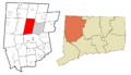
Goshen's location within Litchfield County and Connecticut
-
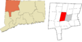
Goshen's location within the Northwest Hills Planning Region and the state of Connecticut
See also
 In Spanish: Goshen (Connecticut) para niños
