Litchfield, Connecticut facts for kids
Quick facts for kids
Litchfield, Connecticut
|
||
|---|---|---|
| Town of Litchfield | ||

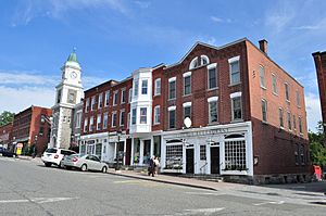
Commercial blocks on West Street
|
||
|
||
| Motto(s):
Unitas Sub Lege (Latin)
"Unity Under the Law" |
||
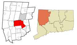
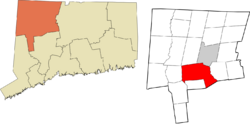
 Litchfield County and Connecticut Litchfield County and Connecticut Northwest Hills Planning Region and Connecticut Northwest Hills Planning Region and Connecticut |
||
| Country | ||
| U.S. state | ||
| County | Litchfield | |
| Region | Northwest Hills | |
| Incorporated | 1719 | |
| Government | ||
| • Type | Selectman-town meeting | |
| Area | ||
| • Total | 56.8 sq mi (147.1 km2) | |
| • Land | 56.1 sq mi (145.3 km2) | |
| • Water | 0.7 sq mi (1.8 km2) | |
| Elevation | 1,080 ft (329 m) | |
| Population
(2020)
|
||
| • Total | 8,192 | |
| • Density | 146/sq mi (56.4/km2) | |
| Time zone | UTC-5 (EST) | |
| • Summer (DST) | UTC-4 (EDT) | |
| ZIP code |
06750 [Bantam], 06759 [Litchfield], 06778 [Northfield]
|
|
| Area code(s) | 860/959 | |
| FIPS code | 09-43370 | |
| GNIS feature ID | 0213452 | |
| Major highways | ||
Litchfield is a town in Connecticut, United States. It used to be the main town for Litchfield County. In 2020, about 8,192 people lived there. Litchfield is part of the Northwest Hills Planning Region.
Inside the town of Litchfield, you'll find two smaller areas called boroughs: Bantam and Litchfield. There are also three villages that are not officially separate towns: East Litchfield, Milton, and Northfield. Northfield, located in the southeast part of Litchfield, is where many of the town's residents live.
Contents
Litchfield's Early History
Litchfield was first known as Bantam township. It officially became a town in 1719. The town got its name from a place in England called Lichfield.
In 1751, Litchfield became the county seat for Litchfield County. This means it was the main town where the county's government was located. Around the same time, the borough of Litchfield was planned out.
During the American Revolutionary War, Litchfield played an important role.
- From 1776 to 1780, the town stored military supplies.
- It also had a workshop for the Continental Army.
- A large statue of King George III from New York City was brought to Litchfield.
- In the home of Oliver Wolcott, the statue was melted down.
- Wolcott's daughter and sister turned the lead into bullets for the American army.
Important people who supported the British, called Loyalists, were held prisoner in Litchfield during the war. These included William Franklin, who was the son of Benjamin Franklin, and David Mathews, the mayor of New York City.
First Law School in the U.S.
In 1784, the very first law school in the United States opened in Litchfield. It was called the Litchfield Law School. Judge Tapping Reeve started it. He had been teaching law to students since 1773. Because so many people wanted to learn from him, he formally opened the school.
Over 50 years, more than 1,100 students attended this school. Some famous students included Aaron Burr, Jr., Horace Mann, and Levi Woodbury. Woodbury was the first justice on the US Supreme Court to have gone to law school.
Pioneering Women's Education
Litchfield was also home to a groundbreaking school for young women. The Litchfield Female Academy was founded in 1792 by Sarah Pierce. This school helped educate many young women during a time when such opportunities were rare.
Litchfield has a very rich history. The Litchfield Historical Society, located in the town center, has many items important to the town's past.
Litchfield's Location and Geography
Litchfield is located southwest of Torrington. Part of Bantam Lake is also within the town's borders.
The town covers about 56.8 square miles (147.1 square kilometers). Most of this area, about 56.1 square miles (145.2 square kilometers), is land. The rest, about 0.7 square miles (1.9 square kilometers), is water.
Litchfield is about 95 miles (153 km) from Central Park in New York City. It's also about 50 miles (80 km) from the Hudson River Valley. The nearest coast, on Long Island Sound, is about 40 miles (64 km) away.
Main Communities in Litchfield
- Bantam (a borough)
- East Litchfield (a village not officially separate)
- Litchfield (the main borough and town center)
- Milton (a village not officially separate)
- Northfield (a village not officially separate)
Population of Litchfield
| Historical population | |||
|---|---|---|---|
| Census | Pop. | %± | |
| 1790 | 20,342 | — | |
| 1800 | 4,285 | −78.9% | |
| 1810 | 4,639 | 8.3% | |
| 1820 | 4,610 | −0.6% | |
| 1830 | 4,456 | −3.3% | |
| 1840 | 4,038 | −9.4% | |
| 1850 | 3,953 | −2.1% | |
| 1860 | 3,200 | −19.0% | |
| 1870 | 3,113 | −2.7% | |
| 1880 | 3,410 | 9.5% | |
| 1890 | 3,304 | −3.1% | |
| 1900 | 3,214 | −2.7% | |
| 1910 | 3,005 | −6.5% | |
| 1920 | 3,180 | 5.8% | |
| 1930 | 3,574 | 12.4% | |
| 1940 | 4,029 | 12.7% | |
| 1950 | 4,964 | 23.2% | |
| 1960 | 6,264 | 26.2% | |
| 1970 | 7,399 | 18.1% | |
| 1980 | 7,605 | 2.8% | |
| 1990 | 8,365 | 10.0% | |
| 2000 | 8,316 | −0.6% | |
| 2010 | 8,466 | 1.8% | |
| 2020 | 8,192 | −3.2% | |
| U.S. Decennial Census | |||
In 2000, there were 8,316 people living in Litchfield. There were 3,310 households, and 2,303 families. The population density was about 148 people per square mile (57 per square kilometer).
The people living in Litchfield were mostly White (96.99%). There were also smaller percentages of Black or African American, Native American, Asian, and Pacific Islander residents. About 1.56% of the population was Hispanic or Latino.
The average household had 2.45 people, and the average family had 2.98 people.
- 25.2% of the population was under 18 years old.
- 3.6% were between 18 and 24.
- 25.6% were between 25 and 44.
- 28.6% were between 45 and 64.
- 17.0% were 65 years or older.
The average age in town was 43 years old. For every 100 females, there were about 92.5 males.
The average income for a household in Litchfield was $58,418. For a family, the average income was $70,594. About 4.0% of the population lived below the poverty line.
Getting Around Litchfield
U.S. Route 202 is the main road that goes east-west. It connects Bantam and Litchfield center to the cities of Torrington and New Milford, Connecticut. Route 63 runs north-south through the town center.
The Route 8 expressway runs along the border with Harwinton. You can get to it from the town center using Route 118.
Buses from the Northwestern Connecticut Transit District also serve the town. They connect Litchfield to Torrington. A train line, the Shepaug Valley Railroad, used to have a station in Litchfield. It opened in 1872, but passenger service stopped in 1930 and freight service ended in 1948.
Schools in Litchfield
Litchfield Public Schools runs the public schools in town. Litchfield High School is the local high school.
Students can also choose to attend other schools:
- Wamogo Regional Six in Litchfield, which offers agricultural studies.
- Oliver Wolcott Technical School in Torrington.
For younger students:
- Litchfield Center School teaches children from kindergarten to 3rd grade. It also has a Pre-K program.
- Students then go to Litchfield Intermediate School until 6th grade.
- After that, they finish their public school education at Litchfield High School.
Litchfield is also home to Forman School. This is a private boarding school for students in grades 9-12 and post-graduate. It specializes in helping students with learning differences like ADD/ADHD and dyslexia.
Famous People from Litchfield
- Andrew Adams, a political leader during and after the American Revolution.
- Ethan Allen, one of the people who helped found Vermont.
- Catharine Beecher, an important educator.
- Henry Ward Beecher, a well-known clergyman.
- Lyman Beecher, a Presbyterian minister.
- Solyman Brown, who created the first dental school.
- Dick Ebersol, a television executive.
- Elizabeth Gilbert, the author of Eat, Pray, Love.
- Jane Grant, a writer.
- Isabella Beecher Hooker, an activist for women's right to vote.
- Susan Saint James, an actress.
- Madeleine L'Engle, a famous author.
- Charles B. McVay III, a US naval officer.
- Sarah Pierce, a teacher and founder of the Litchfield Female Academy.
- Tapping Reeve, a lawyer, judge, and law teacher.
- Richard Skinner, a former governor of Vermont.
- Harriet Beecher Stowe, an abolitionist and author of Uncle Tom's Cabin.
- Benjamin Tallmadge, an American military officer during the Revolutionary War.
- Paul Winter, a saxophonist.
- Oliver Wolcott Sr., who signed the U.S. Declaration of Independence.
- Oliver Wolcott Jr., a US Secretary of the Treasury and later the 24th governor of Connecticut.
Historic Places in Litchfield

Several places in Litchfield are listed on the National Register of Historic Places. This means they are important historical sites.
- Captain William Bull Tavern – a historic tavern.
- Henry B. Bissell House – a historic house.
- J. Howard Catlin House – another historic house (it has since been taken down).
- Litchfield Historic District – a large area with many historic buildings.
- Milton Center Historic District – a historic area in Milton.
- Humaston Brook State Park – a state park with historical significance.
- Oliver Wolcott House – the home of Oliver Wolcott.
- Rye House – a historic house.
- Tapping Reeve House and Law School – the home and school of the famous law teacher.
- Topsmead – a state forest.
See also
 In Spanish: Litchfield (Connecticut) para niños
 | James B. Knighten |
 | Azellia White |
 | Willa Brown |


