
New Haven County, Connecticut facts for kids
Quick facts for kids
New Haven County
|
|
|---|---|

|
|

Location within the U.S. state of Connecticut
|
|
 Connecticut's location within the U.S. |
|
| Country | |
| State | |
| Founded | 1666 |
| Named for | New Haven Colony |
| Seat | none (since 1960) New Haven (before 1960) |
| Largest municipality | New Haven (population) Guilford (area) |
| Area | |
| • Total | 862 sq mi (2,230 km2) |
| • Land | 605 sq mi (1,570 km2) |
| • Water | 258 sq mi (670 km2) 29.9%% |
| Population
(2020)
|
|
| • Total | 864,835 |
| • Density | 1,429.5/sq mi (551.9/km2) |
| Time zone | UTC−5 (Eastern) |
| • Summer (DST) | UTC−4 (EDT) |
| Congressional districts | 2nd, 3rd, 4th, 5th |
New Haven County is a region in the south-central part of Connecticut. It is one of the eight counties in the state. In 2020, about 864,835 people lived here. This makes it the third-most populated county in Connecticut.
Two of Connecticut's biggest cities are in New Haven County. These are New Haven (the 3rd largest) and Waterbury (the 5th largest). New Haven County is part of a larger area called the New Haven-Milford Metropolitan Statistical Area. This area is also connected to the even bigger New York metropolitan region.
In Connecticut, counties like New Haven County do not have their own governments. This changed in 1960. Before then, New Haven was the county seat, which is like the main city for the county government. Now, local towns handle all government tasks. This includes things like fire departments, schools, and clearing snow. Sometimes, nearby towns work together on these services. So, New Haven County is mostly just a name for a group of towns on a map. It does not have its own government power.
Contents
History of New Haven County
New Haven County was created a very long time ago. It was formed on May 10, 1666. This happened after the New Haven Colony joined with the Connecticut Colony. The leaders wanted to make the area more organized.
When it was first made, New Haven County included only three towns: Milford, New Haven, and Guilford. Over many years, more towns were added. For example, Wallingford joined in 1671. Derby was added later, and Waterbury became part of the county in 1728. The county's borders changed several times as new towns were created. The final changes to the county's shape happened in 1807. This was when the town of Middlebury was established.
Geography of New Haven County
New Haven County covers a total area of about 862 square miles. About 605 square miles of this is land. The rest, about 258 square miles, is water. This means almost 30% of the county is water! It is the second-largest county in Connecticut by its total area.
Land and Water Features
Near the coast, the land is mostly flat. As you move inland, there are low hills. These hills get taller in the northern part of the county. The highest points are in the town of Wolcott. They are about 1,050 feet above sea level. The lowest point is at sea level, along the coast.
Some famous natural spots in the county include Mount Carmel, which looks like a sleeping giant. There are also two large rock formations called West Rock and East Rock.
Neighboring Areas
New Haven County shares its borders with other counties:
- Hartford County is to the north.
- Middlesex County is to the east.
- Fairfield County is to the west.
- Litchfield County is to the northwest.
To the south, New Haven County is next to Long Island Sound. This is a large body of water that connects to the Atlantic Ocean.
Protected Natural Areas
Part of the Stewart B. McKinney National Wildlife Refuge is located in New Haven County. This is a special area set aside to protect wildlife.
Transportation in New Haven County
New Haven County has several important roads that help people travel around.
Major Roads
U.S. Route 1: The Boston Post Road
U.S. Route 1 is a very old road. It runs along the coastline through all the towns there. People often call it the "Boston Post Road." This road goes from west to east.
Interstate 91
Interstate 91 starts in New Haven. It connects with I-95 there. This highway goes north towards Hartford and then to Vermont. It runs next to U.S. Route 5.
Interstate 95
Interstate 95 in Connecticut is a major highway. It is also known as the Connecticut Turnpike. It runs across the state, generally parallel to U.S. Route 1. This highway has six or sometimes eight lanes in the county. It was finished in 1958. It can get very busy, especially during morning and evening rush hours.
Wilbur Cross Parkway
The Wilbur Cross Parkway (also called Connecticut Route 15) is a scenic road. Trucks are not allowed on it. It runs through the county, usually a few miles north of Interstate 95. This parkway is a National Scenic Byway. It is also listed on the National Register of Historic Places because of its historical importance. It even goes through the Heroes Tunnel in New Haven.
Interstate 84
Interstate 84 goes through Danbury and Waterbury. There are plans to make it wider, with six lanes. This widening aims to help drivers and might encourage some cars to use I-84 instead of the often-crowded I-95.
People and Population
New Haven County has seen its population grow a lot over the years. In 1790, about 30,703 people lived here. By 2020, the population had grown to 864,835 people.
Population Details from 2010
In 2010, there were 862,477 people living in New Haven County. Most people (74.8%) were white. About 12.7% were black or African American. About 3.5% were Asian. People of Hispanic or Latino origin made up 15.0% of the population.
Many people in the county have roots from different countries. The most common ancestries were Italian (24.0%), Irish (17.5%), German (9.3%), and English (8.5%).
The average age of people in the county was 39.3 years old. The average income for a household was about $61,114 per year. For families, the average income was about $77,379.
Education in New Haven County
New Haven County has many schools and colleges.
Schools for Kids
Each town in the county usually has its own schools. Some smaller towns work together to form regional school districts. For example, Bethany, Orange, and Woodbridge are part of Region 5. Middlebury and Southbury are in Region 15. Beacon Falls and Prospect are in Region 16.
There are many school districts that serve students from kindergarten to 12th grade. These include districts in Ansonia, Branford, Cheshire, Derby, East Haven, Guilford, Hamden, Madison, Meriden, Milford, Naugatuck, New Haven, North Branford, North Haven, Oxford, Seymour, Wallingford, Waterbury, West Haven, Wolcott, and Woodbridge.
Colleges and Universities
New Haven County is a big center for higher education. Many well-known colleges and universities are located here, especially around the city of New Haven. These include:
- Albertus Magnus College
- Gateway Community College
- Naugatuck Valley Community College
- Paier College of Art
- Post University
- Quinnipiac University
- Southern Connecticut State University
- University of Connecticut
- University of New Haven
- Yale University
Communities of New Haven County
New Haven County is made up of many different cities and towns.
Cities in the County
Towns in the County
Images for kids
-
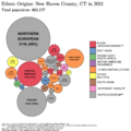
This map shows where people in New Haven County came from in 2010.
-
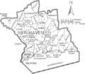
A map showing the cities and towns in New Haven County, Connecticut.


See also
 In Spanish: Condado de New Haven para niños
