Interstate 95 in Connecticut facts for kids
Quick facts for kids
Interstate 95 |
||||
|---|---|---|---|---|
| Jewish War Veterans Memorial Highway Connecticut Turnpike |
||||
 |
||||
| Route information | ||||
| Maintained by ConnDOT | ||||
| Length | 111.57 mi (179.55 km) | |||
| Existed | 1958-1964–present | |||
| Location | ||||
| Counties: | Fairfield, New Haven, Middlesex, New London | |||
| Highway system | ||||
| Main route of the Interstate Highway System Main • Auxiliary • Business Routes in Connecticut
|
||||
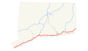
Interstate 95 (often called I-95) is a very important highway in the United States. It runs along the entire East Coast, connecting many major cities. In Connecticut, I-95 stretches for about 111.57 miles (179.55 km).
Most of I-95 in Connecticut is also known as the Connecticut Turnpike. This part of the highway connects to the New England Thruway in New York State. Near New London, I-95 leaves the Turnpike. It then continues east towards Westerly, Rhode Island. The Turnpike itself turns north from there, becoming Interstate 395.
Contents
What is Interstate 95?
Interstate 95 is part of the Interstate Highway System. This is a huge network of highways across the United States. These roads help people travel long distances quickly and safely. They are also very important for moving goods and supplies.
Why is I-95 so important?
I-95 is one of the busiest highways in the country. It connects many large cities along the East Coast. Think of it like a main street for the entire eastern side of the U.S. It helps millions of people get to work, school, and vacation spots. It also helps businesses transport products.
I-95's Path Through Connecticut
I-95 enters Connecticut from New York. It travels through several counties in the state. These include Fairfield, New Haven, Middlesex, and New London.
Major Cities Along I-95 in Connecticut
As you travel on I-95 through Connecticut, you'll pass by or near several important cities. These cities are busy centers for people and businesses.
I-95 also connects to other major cities outside Connecticut. These include New York City, New York and Providence, Rhode Island.
History of I-95 in Connecticut
The construction of I-95 in Connecticut took place between 1958 and 1964. This was a big project to build a modern highway. It made travel much easier and faster across the state.
The Connecticut Turnpike
A large part of I-95 in Connecticut is also known as the Connecticut Turnpike. This section was originally a toll road. This means drivers had to pay a fee to use it. The money collected helped pay for the road's construction and upkeep. Over time, the tolls were removed.
Images for kids
 | Jackie Robinson |
 | Jack Johnson |
 | Althea Gibson |
 | Arthur Ashe |
 | Muhammad Ali |


