
Fairfield County, Connecticut facts for kids
Quick facts for kids
Fairfield County
|
|
|---|---|

|
|

Location within the U.S. state of Connecticut
|
|
 Connecticut's location within the U.S. |
|
| Country | |
| State | |
| Founded | 1666 |
| Named for | The hundreds of acres of salt marsh that bordered the coast. |
| Seat | none; since 1960 Connecticut counties no longer have a county government Fairfield (1666–1853) Bridgeport (1853–1960) |
| Largest municipality | Bridgeport (population) Newtown (area) |
| Area | |
| • Total | 837 sq mi (2,170 km2) |
| • Land | 625 sq mi (1,620 km2) |
| • Water | 212 sq mi (550 km2) |
| Population
(2020)
|
|
| • Total | 957,419 |
| • Estimate
(2021)
|
958,768 |
| • Density | 1,532/sq mi (592/km2) |
| Time zone | UTC−5 (Eastern) |
| • Summer (DST) | UTC−4 (EDT) |
| Congressional districts | 3rd, 4th, 5th |
Fairfield County is a county located in the southwestern part of Connecticut, a state in the United States. It is the most populated county in Connecticut. From 2010 to 2020, it was also the fastest-growing county in the state.
In 2020, about 957,419 people lived here. This was more than a quarter of Connecticut's total population. Fairfield County is very close to the New York City area. It includes four of Connecticut's seven biggest cities: Bridgeport, Stamford, Norwalk, and Danbury. Together, these cities have almost half of the county's population.
Fairfield County is part of the larger New York–Newark–Bridgeport combined statistical area. This is the largest population area in the United States.
Unlike many other counties in the U.S., Fairfield County does not have its own county government or a county seat. This is true for all counties in Connecticut since 1960. Instead, local cities and towns handle all government services. These include fire and rescue, schools, and snow removal. Sometimes, nearby towns share resources. The last county seat was Bridgeport, from 1853 to 1960.
Fairfield County is known for its wealthy areas, especially along the "Gold Coast". This area helped make Connecticut one of the richest states. However, other parts of the county are more crowded and have different kinds of businesses.
Contents
History of Fairfield County
Early Inhabitants and European Settlers
Before Europeans arrived, many Native American tribes lived in Fairfield County. The Schaghticoke tribe lived where New Fairfield and Sherman are today. Other tribes included the Paugussetts, Tankiteke, and Siwanoy.
The first European settlers were Puritans from England. In 1614, Dutch explorer Adriaen Block explored the coast. Later, Roger Ludlow helped buy land and start the towns of Fairfield (1639) and Norwalk (1640). Ludlow chose the name Fairfield because of its beautiful fields. The town of Stratford was also settled in 1639 by Adam Blakeman and William Beardsley.
How Fairfield County Was Formed
Fairfield County was officially created on May 10, 1666. It was one of the first four counties in Connecticut. The original towns were Rye, Greenwich, Stamford, Norwalk, Fairfield, and Stratford.
Over time, the county's borders changed. In 1673, Woodbury was added. In 1683, Rye became part of New York. More towns joined Fairfield County in the late 1600s and early 1700s, like Danbury (1687), Ridgefield (1709), Newtown (1711), and New Fairfield (1740). In 1751, Woodbury moved to Litchfield County. The last change was in 1788 when Brookfield was formed, adding some land from Litchfield County.
Important People in Early Fairfield County
- Joseph Hawley (1603–1690) moved to Stratford in 1650 and became its first town clerk. His son, Ephraim, built the Ephraim Hawley House in Trumbull in 1683, which is still standing.
- Thomas Fitch (around 1700–1774) from Norwalk was a governor of the Connecticut Colony.
- Gold Selleck Silliman (1732–1790) from Fairfield fought in the American Revolutionary War. He became a general in 1776.
Fairfield County During the Revolutionary War

Connecticut was known as "the Provisions State" because it produced a lot of food for the American army. In 1777, British General William Howe ordered attacks to stop supplies from reaching the Continental Army. British troops raided Danbury on April 22, 1777. American General David Wooster defended the supplies with fewer troops.
In 1779, General Israel Putnam escaped a British raid in Greenwich. He rode his horse to warn people in Stamford. His hat, with a musket ball hole, is displayed at Knapp's Tavern in Greenwich. Later that summer, British troops attacked coastal towns like New Haven, Fairfield, and Norwalk, burning many buildings.
Growth and Industry
In 1801, the Danbury Baptist Association wrote to President Thomas Jefferson about religious freedom. Jefferson replied in 1802, saying the First Amendment to the United States Constitution created a "wall of separation between church and State" to protect their rights.
The first railroad, the Housatonic Railroad, was built from 1836 to 1840. It connected Bridgeport to New Milford, helping farmers transport crops. The New York and New Haven railroad, built in the 1840s, connected coastal towns like Bridgeport, Stamford, and Norwalk.
In 1851, Bridgeport became the county seat, taking over from Fairfield. This was because Bridgeport was growing fast with new industries. The first hospital in the county, Bridgeport Hospital, opened in 1884. Other hospitals followed, including Danbury Hospital (1885) and Norwalk Hospital (1893).
By 1900, Bridgeport was a major manufacturing center. Stamford and Greenwich became popular vacation spots for wealthy New Yorkers. In 1905, Bridgeport produced 20% of America's corsets. During World War I, Bridgeport's population grew quickly, and it produced half of the Allied ammunition. Danbury was known as the "Hat City," making 20% of America's hats. Stamford was called the "Lock City" because of the Yale and Towne Lock Manufacturing Company.
.jpg)
Many large companies had factories in Bridgeport, such as Remington Arms, General Electric, and Sikorsky Aircraft. Even with all this industry, much of the county remained farmland. Westport was a summer home for famous artists and writers like F. Scott Fitzgerald in the 1920s.
Modern Changes
In the 1950s, many families moved from Bridgeport to nearby suburbs like Fairfield. This led to new homes being built. The Connecticut Turnpike (Interstate 95) was built along the coast in the mid-1950s. The Merritt Parkway, a scenic road, was built earlier in the 1930s. These highways helped towns like Westport, Darien, New Canaan, Stamford, and Greenwich become suburbs of New York City.
In 1960, Fairfield County, like all other Connecticut counties, stopped being a government agency. It became more of a geographical area.
Stamford changed a lot in the 1960s and 70s. Its downtown was rebuilt with modern skyscrapers. Many large companies moved their main offices to Stamford, making it a major business hub. Stamford's population grew from 92,713 in 1960 to 135,470 in 2020, making it Connecticut's second-largest city.
Geography
Land Features
Fairfield County covers about 837 square miles. About 625 square miles are land, and 212 square miles (25.3%) are water.
The land is mostly flat near the coast, but it becomes hilly and higher in the northern part. The highest point is about 1,290 feet above sea level near the New York state line in Sherman. The lowest point is sea level itself.
The Taconic Mountains and Berkshire Mountains, which are part of the Appalachian Mountains, run through Fairfield County. A small part of the famous Appalachian Trail also goes through the town of Sherman.
Water Bodies
Fairfield County's western border extends into Long Island Sound. The eastern border is mostly the middle of the Housatonic River.
Many rivers flow through the county, including the Byram, Housatonic, Mianus, Mill, Norwalk, Pequonnock, Rippowam, Saugatuck, and Still.
Some rivers have pollution from past industries. The Still River has mercury from hat factories in Danbury. The Housatonic River has chemicals called PCBs from a General Electric plant that operated until 1977.
Neighboring Counties
Fairfield County shares borders with:
- Litchfield County (north)
- New Haven County (east)
- Westchester County, New York (southwest)
- Putnam County, New York (west)
- Dutchess County, New York (northwest)
- Nassau County, New York (south, across Long Island Sound)
Protected Natural Areas
Climate
Fairfield County has a climate with hot summers. The northern parts can have colder winters, while areas closer to the coast have milder winters.
Economy

Starting in the late 1960s, many large companies moved their main offices to Fairfield County from New York City. This made the area a major business hub. By 1992, Fairfield County had the third-highest number of major international company headquarters in the United States, after New York City and Chicago.
Today, Fairfield County is home to many hedge funds and private equity firms. These financial companies are often found in towns like Greenwich, Stamford, and Westport. Some major ones include Bridgewater Associates and AQR Capital.
The county is also a top spot for aquaculture (farming seafood) in Connecticut.
Hospitals
Fairfield County has several hospitals that provide healthcare services:
- Bridgeport Hospital
- Danbury Hospital
- Greenwich Hospital
- Norwalk Hospital
- St. Vincent's Medical Center (Bridgeport) in Bridgeport
- Stamford Hospital
Transportation
Traffic can be heavy on major roads like Interstate 95 and the Merritt Parkway. Because of this, state officials are working to improve public transportation. New office buildings are often built near train stations to encourage more people to use trains for commuting.
Airports
Fairfield County has two regional airports:
- Igor I. Sikorsky Memorial Airport in Stratford
- Danbury Municipal Airport in Danbury
Larger airports like John F. Kennedy International Airport and LaGuardia Airport in New York City also serve the county.
Bus Services
Different bus companies serve various parts of the county:
- Connecticut Transit's Stamford division covers the southern part.
- The Norwalk Transit District serves the Norwalk area.
- The Greater Bridgeport Transit Authority serves Bridgeport and eastern Fairfield County.
- The Housatonic Area Regional Transit agency serves Danbury and the northern parts.
Ferry Services
The Bridgeport & Port Jefferson Ferry carries passengers and cars from Bridgeport to Port Jefferson, New York, across Long Island Sound.
Train Services
Commuter trains are very important for Fairfield County residents. They offer an easy way to get to Grand Central Terminal in New York City. Metro-North's New Haven Line serves all shoreline towns. Branch lines connect to New Canaan from Stamford and to Danbury from South Norwalk. Many trains run express, making the trip to New York City quick.
New train cars are being added to the Metro-North New Haven Line to replace older ones.
Bridgeport and Stamford also have Amtrak service. Many people use the Northeast Regional route from these cities.
Major Roads
U.S. Route 1 (Boston Post Road)
U.S. 1 is the oldest east-west road in the county. It runs through all the towns along the coast. It is often called "Boston Post Road" or "Post Road." The name changes in different towns, for example, Putnam Avenue in Greenwich or Main Street in Stamford.
Interstate 95
Interstate 95 is also known as the Connecticut Turnpike in Fairfield County. It runs roughly parallel to U.S. Route 1. This highway has six to eight lanes and was finished in 1958. It often has heavy traffic, especially during busy morning and evening hours.
Merritt Parkway
The Merritt Parkway, or Connecticut Route 15, is a beautiful road where trucks are not allowed. It runs north of Interstate 95. It starts at the New York state line and becomes the Wilbur Cross Parkway at the New Haven county line. The Merritt Parkway is a National Scenic Byway and is listed on the National Register of Historic Places.
Interstate 84
Interstate 84 goes through Danbury. There are plans to make it wider to six lanes between Danbury and Waterbury. This might help reduce traffic on Interstate 95.
U.S. Route 7
U.S. Route 7 starts in Norwalk and goes north through Wilton, Ridgefield, Danbury, and Brookfield. This route was once part of an old Native American trail. Parts of Route 7 have been widened over the years.
Sports
Fairfield County is home to several sports teams:
| Team | Sport | League |
|---|---|---|
| AC Connecticut | Soccer | USL League Two |
| Bridgeport Islanders | Ice hockey | American Hockey League |
| Connecticut Whale | Ice hockey | Premier Hockey Federation |
| Connecticut Brakettes | Fastpitch softball | USA Softball |
| Danbury Colonials | Ice hockey | NA3HL |
| Danbury Hat Tricks | Ice hockey | Federal Prospects Hockey League |
| Danbury Westerners | Baseball | New England Collegiate Baseball League |
| Fairfield Yankees RFC | Rugby union | New England Rugby Football Union |
Some teams that used to play in Fairfield County include the Bridgeport Bluefish (baseball) and the Danbury Whalers (hockey). Since the county is close to New York City, many people also support the major professional sports teams from New York and New Jersey.
Communities


Fairfield County has many different towns and cities. Some towns also have smaller villages or neighborhoods within them.

- Bethel (town)
- Bridgeport (city, used to be the county seat)
- Brookfield (town)
- Danbury (city)
- Darien (town)
- Easton (town)
- Fairfield (town)
- Greenwich (town)
- Monroe (town)
- New Canaan (town)
- New Fairfield (town)
- Newtown (town, includes the borough of Newtown)
- Norwalk (city)
- Redding (town)
- Ridgefield (town)
- Shelton (city)
- Sherman (town)
- Stamford (city)
- Stratford (town)
- Trumbull (town)
- Weston (town)
- Westport (town)
- Wilton (town)
Telephone Area Codes
Most of Fairfield County uses telephone area code 203 or area code 475. However, the town of Sherman uses area code 860.
Major Media in the County
Fairfield County has several local newspapers and is also covered by New York City TV stations.
- The Advocate of Stamford (Stamford and Norwalk editions)
- Connecticut Post (Bridgeport)
- Greenwich Time (Greenwich)
- The Hour (Norwalk)
- The News-Times of Danbury (Danbury)
- The Fairfield County Business Journal
- The Newtown Bee
- The Darien Times
- The Redding Sentinel
- The Easton Courier
There are also Spanish language newspapers like El Sol News, El Canillita, and Pluma Libre. Other foreign language newspapers include Haitian Voice and BrazilNowUSA.
News 12 Connecticut has studios in Norwalk and covers news for Fairfield County and the state.
Colleges and Universities
Fairfield County has several colleges and universities:
- Housatonic Community College in Bridgeport
- University of Bridgeport in Bridgeport
- University of Connecticut Stamford campus
- Fairfield University in Fairfield
- Norwalk Community College
- St. Vincent's College in Bridgeport
- Sacred Heart University in Fairfield
- Western Connecticut State University in Danbury
- Lincoln Technical Institute in Shelton
- Norwalk Conservatory of the Arts in Norwalk
Culture and the Arts
Fine Arts
- Franklin Street Works in Stamford is an art space.
- The Housatonic Museum of Art is located at Housatonic Community College in Bridgeport.

Music and Orchestras
Fairfield County is home to several orchestras:
- Greater Bridgeport Symphony (founded 1945)
- Connecticut Grand Opera (founded 1993)
- Danbury Symphony Orchestra
- Greenwich Symphony Orchestra
- Norwalk Symphony Orchestra (founded 1939)
- Ridgefield Symphony Orchestra
- Orchestra Lumos
- Western Connecticut Youth Orchestra (for young musicians)
Other Music and Arts Events
- The Barnum Festival is held every spring in Bridgeport to raise money for charity.
- The Connecticut Film Festival takes place in the spring in Danbury.
- The Fairfield County Freestyle Championships are held at Sacred Heart University, showcasing freestyle dancers and rappers.
- The Gathering of the Vibes music event has been held in Bridgeport's Seaside Park several times.
- Musicals at Richter, held every summer in Danbury, is Connecticut's longest-running outdoor theater.
- The Norwalk Oyster Festival is an annual fair in Norwalk with crafts and live music. It happens in Veterans Park near Long Island Sound.
Images for kids
-

Candlewood Lake in the northern part of the county in the Appalachian Mountains, near the Taconics and Berkshires
-
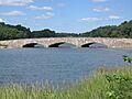
Rings End Bridge, in Darien
-

Huntington State Park
-

View from the top of Webb Mountain in Monroe


See also
 In Spanish: Condado de Fairfield (Connecticut) para niños
