
Merritt Parkway facts for kids
Quick facts for kids
[[File:|x70px|alt= marker]] |
|
|---|---|
|
Merritt Parkway highlighted in red
|
|
| Route information | |
| Length | 37.67 mi (60.62 km) |
| Existed | 1938–present |
| Tourist routes |
|
| Restrictions | No trucks, buses, trailers, towed vehicles, or vehicles taller than 8 ft (2.4 m) |
| Major junctions | |
| South end | |
| North end | |
| Location | |
| Counties: | Fairfield, New Haven |
| Highway system | |
| Routes in Connecticut Special Service Roads • State Roads |
|
|
Merritt Parkway
|
|
| Architect | Connecticut Highway Department; et al. |
| Architectural style | Colonial Revival, Classical Revival, Modern Movement |
| NRHP reference No. | 91000410 |
| Added to NRHP | April 17, 1991 |
The Merritt Parkway (also known as "The Merritt") is a special road in Connecticut. It runs through Fairfield County and a small part of New Haven County. This parkway was made for Connecticut's "Gold Coast" area. It's famous for its beautiful views, unique road signs, and fancy bridges.
The Merritt Parkway is one of the first and oldest parkways in the United States. It's so special that it's called a National Scenic Byway. It's also listed in the National Register of Historic Places. The parkway is part of Route 15. It starts at the New York state line in Greenwich. There, it connects to the Hutchinson River Parkway. It ends at Exit 54 in Milford, where the Wilbur Cross Parkway begins.
Building the parkway took six years. It was built in three parts, even though some people didn't want it. The Connecticut Department of Transportation needed extra money because land in the area was very expensive. The parkway is named after U.S. Congressman Schuyler Merritt. In 2010, a group called the National Trust for Historic Preservation said the Merritt Parkway was one of "America's 11 Most Endangered Historic Places."
Large vehicles like trucks, buses, trailers, and towed vehicles are not allowed on the parkway. Vehicles taller than 8 feet (2.4 m) are also not allowed. This is because the parkway has low bridges, narrow lanes, and sharp turns.
Contents
What Makes the Merritt Parkway Special?
The Merritt Parkway is one of the few highways in the United States listed in the National Register of Historic Places. People love it for the beautiful forests it goes through. They also admire the amazing designs of its bridges.
Unique Bridge Designs
When the parkway was built, each bridge was decorated in its own special way. This meant no two bridges looked exactly alike! However, newer bridges, like those at Exit 39, don't follow this tradition. These newer bridges are made of plain concrete and steel.
Road Features and Speed Limits
The parkway has two lanes going in each direction. When it was first built, it didn't have the long on-ramps and off-ramps that modern highways have. Some entrances are very short or have sharp turns. Some even have stop signs, which can make it tricky to get onto the highway. Many of these entrances have been updated over time. For example, the interchange at Route 111 in Trumbull has a modern design.
The speed limit on the parkway is usually between 45 and 55 miles per hour (70 to 90 km/h). There's a long section between Exit 42 in Westport and Exit 44 in Fairfield. This part is about 5+1⁄2 miles (8.9 km) long and has no exits. Locals sometimes call it the "No Exit Zone."
Vehicle Restrictions
As mentioned, certain vehicles are not allowed on the Merritt Parkway. This includes vehicles taller than 8 feet (2.4 m), those weighing 8,000 pounds (3,600 kg) or more, vehicles towing a trailer, or those with more than four wheels. Sometimes, special permits can be given for very large vehicles to use the parkway.
History of the Merritt Parkway


The Merritt Parkway is one of the oldest scenic parkways in the United States. The first part, from Greenwich to Norwalk, opened on June 29, 1938. The next section, from Norwalk to Trumbull, was finished in November 1939. By 1940, the parkway reached the Housatonic River in Stratford.
The parkway was named after U.S. Congressman Schuyler Merritt. He helped pass the laws that allowed the parkway to be built. The Merritt Parkway was the first part of what later became Route 15. It was built between 1934 and 1940. It stretches for 37 miles (60 km) from the New York state line to the Housatonic River. The idea for the parkway was to help reduce traffic on the busy Boston Post Road in Fairfield County.
Early Days and Rules
After the parkway fully opened in 1940, some travelers would stop to have picnics along the road. A group called the Merritt Parkway Advisory Commission made rules for the parkway. They decided to ban horses, buggies, bicycles, pedestrians, billboards, and U-turns. They even thought about making horse trails along the parkway, but that idea was later dropped.
To make sure local residents were happy, planners worked to make the highway beautiful. Engineers, landscape architects, and architects designed a safe road with exit and entrance ramps, but no intersections. They wanted it to blend in with the countryside.
Bridges and Tolls
The bridges were a very important part of the design. An architect named George L. Dunkelberger designed all of them. Their style showed the popular Art Deco look, mixed with older classical and modern designs. Some of these bridges were built by the Works Progress Administration, a government program that created jobs during the Great Depression.

Tolls were collected on the parkway at a toll plaza in Greenwich. This lasted from June 21, 1939, until June 27, 1988. There were also two other tolls on the Wilbur Cross Parkway. One of the old toll plazas is now kept in Stratford's Boothe Memorial Park. You can still see the flashing lights over each toll lane there.
In 2001, all the parkway's signs were changed. They now have a uniform white-on-green color scheme with a special sawtooth border.
Services Along the Parkway
There are six rest areas or service plazas along the Merritt Parkway. These places have parking lots, gas stations, and convenience stores. This means drivers don't have to leave the parkway to get gas or snacks.
Pairs of these plazas are located across from each other. You can find them in Fairfield (near Exit 46), New Canaan (near Exit 37), and Greenwich (near the state line). The northbound plaza in Greenwich also has a Connecticut welcome center. These plazas were built when the parkway had tolls. They stayed even after the tolls were removed in 1988. This makes the Merritt one of the few toll-free highways with service plazas.
Between 2011 and 2015, all six service plazas were updated. The outside of the buildings kept their original brick and stone look. But the insides were completely modernized. Now, the plazas have modern gas pumps, convenience stores, and Dunkin' Donuts shops. Three of the Merritt's plazas also have a Subway restaurant. Before these updates, there were no fast-food options at the plazas.
In 2013, charging stations for Tesla electric cars were added. These were put at both the northbound and southbound Greenwich service plazas. Other electric car charging options were also added.
Safety on the Merritt Parkway

One of the Merritt's beautiful features can also be a danger. Trees line both sides of the parkway and often grow in the middle. Their branches can hang over the road. Sometimes, branches or even whole trees can fall during bad weather or as they get old.
Some parts of the parkway also don't have guardrails on the right side. This means if a car goes off the road, it could hit a tree.
Tree Safety Efforts
In 2007, people worried about the trees along the parkway. State officials said they would trim and remove some trees more often. In June 2007, a large tree fell on a car near Exit 42 in Westport, causing a tragic accident. In June 2011, another driver was hurt in Stamford when a tree fell on their car.
A study of accidents on Connecticut highways showed that tree-related incidents were more common on the Merritt. State workers now drive slowly along the parkway twice a year. They look for unhealthy trees that might need to be cut down sooner. The shoulder of the parkway is also being made wider. This gives drivers more space to pull over safely.
After big storms like Tropical Storm Irene in 2011 and Hurricane Sandy in 2012, the state started closing the parkway. Many trees and branches fell during these storms. After Hurricane Sandy, a big effort began to remove unhealthy trees. This created more space between the road and the forest.
The parkway also has three sharp curves where drivers need to slow down to 45 miles per hour (72 km/h). Two of these are in Greenwich, and one is in Fairfield.
Future Plans for the Parkway
The Connecticut Department of Transportation (ConnDOT) is looking at plans to change the Merritt's interchange with U.S. Route 7 (US 7) in Norwalk. This is at Exits 39 and 40. The US 7 highway was extended in 1992, passing the Merritt. However, a full connection between the Merritt and US 7 was not built. This meant drivers couldn't easily go from the southbound Merritt to southbound US 7.
ConnDOT and the government made plans for a new interchange. This would connect Main Avenue, the Merritt, and US 7. Work was supposed to start around 2005-2007. But some local groups went to court in 2006. They said the plan was too expensive and didn't consider the parkway's beauty and history. The court agreed, and the plans had to be redesigned.
ConnDOT started talking with the community again in 2017. As of May 2019, they are still working on new plans. They hope to start building sometime between 2021 and 2024.
Merritt Parkway Exit List
Like most highways in Connecticut, the exits on the Merritt Parkway are numbered in order. They don't use mile markers yet, though the state is slowly changing to that system. The exit numbers on the Merritt continue from the Hutchinson River Parkway in New York.
| County | Location | Mile | Roads intersected | Notes | ||
|---|---|---|---|---|---|---|
| Fairfield | Greenwich | 0.00 | 0.00 | – | This is where the Merritt Parkway starts. It continues from the Hutchinson Parkway in New York. | |
| 0.05 | 0.080 | 27 | You can get to NY 120A south from the Hutchinson Parkway. | |||
| 3.39 | 5.46 | 28 | Round Hill Road | This exit goes to the Greenwich Business District. | ||
| 4.16 | 6.69 | 29 | Lake Avenue | |||
| 5.71 | 9.19 | 31 | North Street | This exit also goes to the Greenwich Business District. | ||
| Stamford | 8.89 | 14.31 | 33 | Den Road | This is a special type of exit where you can only turn right to get on or off. | |
| 9.22 | 14.84 | 34 | This exit leads to Downtown Stamford and the University of Connecticut Stamford Campus. | |||
| 10.40 | 16.74 | 35 | ||||
| New Canaan | 13.15 | 21.16 | 36 | |||
| 13.89– 14.10 |
22.35– 22.69 |
37 | ||||
| Norwalk | 16.01 | 25.77 | 38 | This exit goes to Norwalk Community College. | ||
| 16.87– 17.31 |
27.15– 27.86 |
39 | This exit is only for northbound traffic getting off and southbound traffic getting on. It's signed as Exits 39A (south) and 39B (north). There are plans to redesign it. | |||
| 17.53– 17.63 |
28.21– 28.37 |
40 | Signed as Exits 40A (south) and 40B (north). There are no signs for US 7 if you're going northbound. | |||
| Westport | 20.73 | 33.36 | 41 | |||
| 21.59 | 34.75 | 42 | ||||
| Fairfield | 26.95 | 43.37 | 44 | This exit goes to the Fairfield Business District and Fairfield University. | ||
| 28.58 | 46.00 | 46 | This exit goes to the West Campus of Sacred Heart University. | |||
| Trumbull | 29.31 | 47.17 | 47 | Park Avenue | This exit goes to University of Bridgeport and Sacred Heart University. | |
| 30.37 | 48.88 | 48 | This is a modern type of interchange called a single-point urban interchange. | |||
| 31.64 | 50.92 | 49S | You can get to Route 25 south from Exit 52. This is Exit 7A on Route 25 north. | |||
| 32.69 | 52.61 | 49 49N |
Signed as Exit 49 if you're going southbound, and Exit 49N if you're going northbound. These are Exits 8A & B on Route 25 south. | |||
| 32.99 | 53.09 | 50 | This exit is only for southbound traffic getting off and northbound traffic getting on. | |||
| 33.51 | 53.93 | 51 | This exit is only for northbound traffic getting off and southbound traffic getting on. | |||
| 33.77– 34.57 |
54.35– 55.64 |
52 | You can get to Route 8 south from Exit 49S. These are Exits 9-10 on Route 8. | |||
| Stratford | 36.54 | 58.81 | 53 | |||
| Housatonic River | 37.53 | 60.40 | Igor I. Sikorsky Memorial Bridge | |||
| New Haven | Milford | 37.67 | 60.62 | 54 | You can get here through the Milford Parkway. | |
| – | The Merritt Parkway continues north as the Wilbur Cross Parkway. | |||||
| 1.000 mi = 1.609 km; 1.000 km = 0.621 mi | ||||||
Images for kids
-
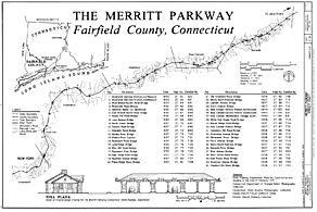
Map of the western part of the Merritt Parkway.
-
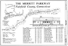
Map of the eastern part of the Merritt Parkway.
-
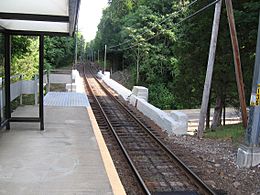
The Talmadge Hill Metro-North train station bridge over the Merritt Parkway in New Canaan.
.jpg)
.jpg)

