
Milford, Connecticut facts for kids
Quick facts for kids
Milford, Connecticut
|
|||
|---|---|---|---|
| City of Milford | |||

Aerial view of Milford city center and harbor
|
|||
|
|||
| Etymology: Ford by a mill | |||
| Nickname(s):
Sleepy Hollow
|
|||
| Motto(s):
A Small City with a Big Heart!
|
|||
 New Haven County and Connecticut New Haven County and Connecticut South Central Connecticut Planning Region and Connecticut South Central Connecticut Planning Region and Connecticut |
|||
| Country | |||
| U.S. state | |||
| County | New Haven | ||
| Region | South Central CT | ||
| Settled | 1639 | ||
| Incorporated (city) | 1959 | ||
| Named for | Milford, Surrey | ||
| Government | |||
| • Type | Mayor–Board of Aldermen | ||
| Area | |||
| • Total | 25.13 sq mi (65.09 km2) | ||
| • Land | 21.91 sq mi (56.73 km2) | ||
| • Water | 3.23 sq mi (8.35 km2) | ||
| Population
(2020)
|
|||
| • Total | 50,558 | ||
| • Density | 2,308/sq mi (891.2/km2) | ||
| United States Census 2010, United States Census Bureau | |||
| Time zone | UTC−5 (Eastern) | ||
| • Summer (DST) | UTC−4 (Eastern) | ||
| ZIP Codes |
06460, 06461
|
||
| Area code(s) | 203/475 | ||
| FIPS code | 09-47515 | ||
| GNIS feature ID | 0208882 | ||
| Major highways | |||
| Commuter Rail | |||


Milford is a city on the coast in New Haven County, Connecticut. It is located between the cities of New Haven and Bridgeport. In 2020, about 50,558 people lived there. Milford includes the smaller areas of Devon and Woodmont. It is part of the larger New York metropolitan area.
Contents
History of Milford
Early Beginnings
The land that is now Milford was bought on February 1, 1639. English settlers bought it from Ansantawae, who was the chief of the local Paugusset tribe. This tribe was part of the Algonquian peoples. The area was first called "Wepawaug" after a small river that flows through the town.

The first mill to grind grain was built on the Wepawaug River in 1640. During the American Revolutionary War, the part of the Boston Post Road that ran through Milford was blocked by American soldiers. Fort Trumbull was built to protect the town. A monument called Liberty Rock marks where the blockade happened.

By 1822, Milford had grown a lot. The northern and eastern parts of Milford became their own town called Orange. For the next 150 years, Milford was known for building ships, farming, and catching oysters. It also became a popular beach resort for people from nearby cities.
In 1899, a "Memorial Bridge" was built over the Wepawaug River. This stone bridge and tower remember the town's history and its first settlers. It has granite blocks with the names of the first settlers carved into them. In 1959, the town of Milford, including the area of Woodmont, officially became the City of Milford.
The "Oatmeal Lots" Story
In 1902, something very unusual happened. The Quaker Oats Company put coupons in their oatmeal boxes. These coupons could be traded for a legal deed to a tiny piece of land in Milford. These small lots were sometimes only 10 feet by 10 feet! They were part of a planned neighborhood called "Liberty Park" that was never built.
Many children (or their parents) collected these deeds. They even started paying the very small property taxes on these "oatmeal lots." The person who planned the neighborhood hoped people would hire him to build houses. But you would need to combine many tiny lots to build just one house.
Because these small lots were created before Milford had rules for planning and zoning, the deeds were completely legal. However, they caused a lot of extra work for the town's tax collectors. It was hard to find the owners, and the town got almost no tax money from these tiny plots.
In the 1970s, Milford wanted to develop the area. So, the town ended the "oatmeal lots" by taking ownership of almost all the land in one legal step. Today, the area where these lots were is home to the BIC Corporation lighter factory.
Milford After World War II
After World War II, Milford grew a lot, just like many other towns in Connecticut. Interstate 95, a major highway, was built through the town and finished in 1958.
In the 1960s and 1970s, the Connecticut Post Mall, one of the state's biggest shopping malls, was built. Many businesses also opened along the Boston Post Road. Since 1975, Milford has hosted the Milford Oyster Festival every year. It's a big tradition, happening "rain or shine."
Milford also became home to the main offices of several big companies. These include the Schick Shaving company and Doctor's Associates, Inc., which owns the Subway restaurant chain. Milford Hospital is also an important healthcare center for the area.
Milford's Population
| Historical population | |||
|---|---|---|---|
| Census | Pop. | %± | |
| 1790 | 2,098 | — | |
| 1800 | 2,417 | 15.2% | |
| 1810 | 674 | −72.1% | |
| 1820 | 2,785 | 313.2% | |
| 1830 | 2,256 | −19.0% | |
| 1840 | 2,455 | 8.8% | |
| 1850 | 2,465 | 0.4% | |
| 1860 | 2,828 | 14.7% | |
| 1870 | 3,405 | 20.4% | |
| 1880 | 3,347 | −1.7% | |
| 1890 | 3,811 | 13.9% | |
| 1900 | 3,783 | −0.7% | |
| 1910 | 4,366 | 15.4% | |
| 1920 | 10,193 | 133.5% | |
| 1930 | 12,660 | 24.2% | |
| 1940 | 16,439 | 29.8% | |
| 1950 | 26,870 | 63.5% | |
| 1960 | 41,662 | 55.1% | |
| 1970 | 50,858 | 22.1% | |
| 1980 | 50,898 | 0.1% | |
| 1990 | 49,938 | −1.9% | |
| 2000 | 52,212 | 4.6% | |
| 2010 | 52,759 | 1.0% | |
| 2020 | 50,558 | −4.2% | |
According to the 2010 US census, about 51,271 people lived in Milford. Most people in Milford are White (93.55%). About 1.91% are African American, and 2.36% are Asian. About 3.34% of the population is Hispanic or Latino.
In 2010, about 29.3% of households had children under 18 living with them. The average household had 2.49 people. The average family had 3.04 people.
Gallery
-
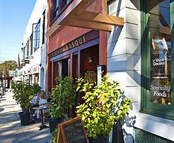
River Street in Downtown Milford
-
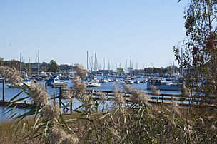
Milford Harbor seen from Pond Street
-
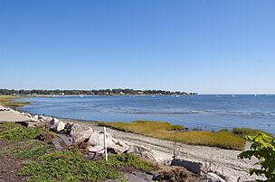
View of coastline from Fort Trumbull Beach, with Gulf Beach in distance
-
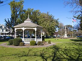
Milford Green, the first longest green in New England
-
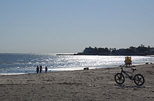
View of Long Island Sound from a Milford beach
-
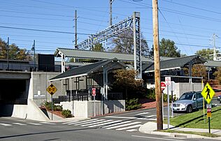
The Milford Metro North Rail Station
-
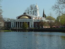
Milford City Hall
-
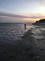
Silver Sands Beach at sunset in Milford
-
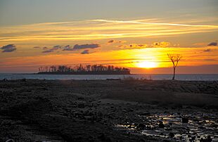
Charles Island, Sunrise at Silver Beach


Education in Milford
Milford Public Schools has eight elementary schools, three middle schools, and two high schools. There is also one alternative high school. The city also has several private schools.
Public Schools
- The Academy
- Calf Pen Meadow Elementary School
- East Shore Middle School
- Harborside Middle School
- John F. Kennedy Elementary School
- Jonathan Law High School
- Joseph A. Foran High School
- Platt Technical High School
- Live Oaks Elementary School
- Mathewson Elementary School
- Meadowside Elementary School
- Orange Avenue Elementary School
- Orchard Hills Elementary School
- Pumpkin Delight Elementary School
- West Shore Middle School
Milford High School was open for 141 years before it closed in 1983. It was the first public high school in Milford, starting in 1842. The old Milford High School building is now the Parson's Government building.
Private Schools
- Academy of Our Lady of Mercy, Lauralton Hall High School
- Charles F. Hayden School (Kindergarten–8th grade)
- Connecticut Center for Child Development (Kindergarten–12th grade)
- The Foundation School (9th–12th grade)
- Milford Christian Academy (Kindergarten–12th grade)
- St. Mary School (Pre-Kindergarten–8th grade) – part of the Archdiocese of Hartford
St. Gabriel's School opened in 1965. It closed in June 2016 because it had fewer students and faced financial challenges.
Emergency Services
Milford Fire Department
The city of Milford is protected by 114 full-time firefighters. They work 24/7, every day of the year. The department has four fire stations across the city. The Milford Fire Department is one of only two fire departments in Connecticut to have an ISO Class 1 rating, which means it's one of the best in the country.
Fire Station Locations and Equipment
Here is a list of fire station locations and the equipment they use in Milford:
| Engine company | Truck company | Rescue ambulance | Special unit | Command unit | Address |
|---|---|---|---|---|---|
| Squad 1 (rescue pumper) | Medic 1, Medic 2 | Squad 1a | Car 4 (Shift Commander), Car 5 (Battalion Chief) | 72 New Haven Ave. | |
| Quint 3, Engine 4 | Haz-Mat. 1, Dive Rescue Unit | 349 Naugatuck Ave. | |||
| Quint 5, Engine 6 | Rescue 234(Collapse Unit), Utility 3 | 980 New Haven Ave. | |||
| Engine 7 | Medic 3 | 55 Wheelers Farms Rd. | |||
| Special Services Canteen Unit | 3 Charles Street |
The Milford Fire Department also has a reserve engine, Engine 8, located at Semans Lane. The Canteen Unit is kept at 3 Charles Street. In 2021, the department added another full-time Medic unit (Medic 3) and removed Tower 1 from service.
Milford Police Department
As of April 4, 2014, the Milford Police Department is one of 28 police departments in Connecticut to be accredited by the state. This means they meet high standards for police work. The current chief of Milford Police is Keith L Mello.
Main Communities of Milford

- Downtown Milford
- Devon
- Rivercliff
- Morningside†
- Point Beach†
- Bayview†
- Walnut Beach†
- Wildermere Beach†
- Laurel Beach†
Other smaller areas and natural spots include Anchor Beach, Burwells Beach, Cedar Beach, Fort Trumbull, Gulf Beach, Merwin's Beach, Milford Point, Myrtle Beach, Silver Sands Beach, and Wheelers Farms.
† These communities have special charters from the state. They have some powers like a city, including the ability to collect taxes. ‡ The Borough of Woodmont is also chartered by the state. It has all the powers of a city, but it is still part of Milford.
Culture and Fun Events

Every year on the third Saturday in August, Milford hosts its annual Oyster Festival. This event is like a town fair but also celebrates the town's history with shellfish from Long Island Sound. The festival happens around the Milford Green and downtown. It includes many activities like canoe and kayak races, live music, and classic car shows.
Famous music groups like Joan Jett and Soul Asylum have performed at the Milford Oyster Festival. You can also find carnival rides, food stands, crafts, face painting, and even open your own oyster to find a pearl!
The Milford Cultural Center offers different events throughout the year. The Firehouse Art Gallery recently opened in Devon. Milford is still a popular beach town with several rocky beaches, Silver Sands State Park, and the Connecticut Audubon Society Coastal Center at Milford Point. There are also two golf courses and other fun places for residents and visitors.
Since 2011, the Walnut Beach Concert Series has held free concerts every Sunday afternoon during the summer under the pavilion at Walnut Beach.
Milford's Economy
Top Employers
Here are the top employers in Milford, based on a 2022 report:
| # | Employer | Employees |
|---|---|---|
| 1 | City of Milford, Board of Education | 1,030 |
| 2 | Schick | 738 |
| 3 | City of Milford | 532 |
| 4 | Bridgeport Hospital (Milford Campus) | 517 |
| 5 | Inline Plastics Corps | 295 |
| 6 | Walmart | 276 |
| 7 | Alinibal Holdings Corp | 248 |
| 8 | Quadient Inc | 247 |
| 9 | West River Rehab Center | 219 |
| 10 | Stop & Shop | 215 |
Geography and Environment
Milford covers about 25.13 square miles (65.09 square kilometers). About 21.91 square miles (56.73 square kilometers) is land, and 3.23 square miles (8.35 square kilometers) is water.
The Devon area of Milford is located where the Housatonic River meets the ocean, near Stratford. You can find the Connecticut Audubon Coastal Center there, which looks out over the river's mouth.
Islands and Coastline

Milford has over 14 miles of shoreline along Long Island Sound, which is the most of any town in Connecticut. A big part of Milford's coast is Silver Sands State Park. A new boardwalk, about three-quarters of a mile long, opened in 2011. It connects Silver Sands to Walnut Beach in Devon. Charles Island is also part of the park and is a protected place for birds to nest.
At low tide, you can walk across a sandbar from Silver Sands Beach to Charles Island. This sandbar is called a tombolo. The island was formed by glaciers at the end of the last ice age. Milford also has three islands in the Housatonic River: Fowler Island, Duck Island, and Nells Island.
Besides Silver Sands State Park, Milford has five public beaches with lifeguards for its residents: Gulf Beach, Anchor Beach, Hawley Avenue Beach, Walnut Beach, and Middle Beach. There are also seven private beaches.
Transportation
Major highways like Interstate 95 and U.S. Route 1 run through the southern part of Milford. The Wilbur Cross Parkway crosses the northern part of the city. It connects to I-95 and Route 1 by the Milford Parkway.
The Metro-North New Haven Line has a train station in downtown Milford (Milford station). From there, you can take a direct train to New York City. The Milford Transit District provides bus service within the town. You can also connect to bus services for nearby cities like Bridgeport and New Haven.
Historic Places
Many places in Milford are listed on the National Register of Historic Places. This means they are important and protected because of their history. Some of these places include:
- Academy of Our Lady of Mercy Lauralton Hall — 200 High St. (added in 2011)
- Buckingham House — 61 North Street (added in 1977)
- Eells-Stow House — 34 High St. (added in 1977)
- Hebrew Congregation of Woodmont — 15 and 17 Edgefield Ave. (added in 1995)
- Housatonic River Railroad Bridge — Amtrak right-of-way at Housatonic River (added in 1987)
- Milford Point Hotel — 1 Milford Point Road (added in 1988)
- River Park Historic District — Roughly bounded by Boston Post Road, Cherry St. and Amtrak, and High St. (added in 1986)
- St. Peter's Episcopal Church — 61, 71, 81 River St. (added in 1979)
- Taylor Memorial Library — 5 Broad St. (added in 1979)
- US Post Office-Milford Main — 6 W. River St. (added in 1986)
- Washington Bridge — spans the Housatonic River to Stratford (added in 2004)
Notable People from Milford
- Mark Arcobello, ice hockey player
- Dylan Bruno, actor
- Jeff Davis, creator of the TV show Teen Wolf
- Justin Gallagher, bike jump builder
- Anne Griffin, actress
- Doug Henry, National Champion motocross and snowmobile racer
- Simon Lake (1866–1945), inventor and naval engineer
- Jonathan Law (1674–1750), colonial era judge; Governor of the Colony of Connecticut, 1741–1750
- Joseph Plumb Martin (1760–1850), Revolutionary War soldier
- Abigail Merwin (1759–1786), colonial-era wife who warned local soldiers about a British attack
- Victor Miller (writer)
- Ellen Muth, actress
- Erin Pac, won a bronze medal for bobsleigh at the 2010 Winter Olympics
- Dan Patrick, sportscaster and radio personality
- Dr. Lucy Creemer Peckham (1842–1923), doctor and poet
- Jason Peter, football player
- Catherine Pollard (c. 1918–2006), first female Scoutmaster in the Boy Scouts of America
- Charles H. Pond (1781–1861), judge and Governor of Connecticut
- Peter Pond (c. 1739–1807), early explorer of North America
- Peter L. Pond (1933–2000), human rights activist
- Jonathan Quick, NHL goaltender for the New York Rangers; Stanley Cup champion
- Christy Carlson Romano, actress
- Dan Rusanowsky, NHL radio broadcaster
- Al Scaduto (1928–2007), cartoonist
- Frank J. Sprague (1857–1934), inventor of electric motors and railways
- Robert Treat (c. 1624–1710), colonial era military officer and Governor of Connecticut
- Tyler Turner (b. 1996), soccer player
Movies Filmed in Milford
Several movies have been filmed, at least in part, in Milford:
- The Light That Failed (1916)
- Man on a Swing (1974)
- Daylight (1996)
- The Toaster Streudel Boy (2000)
- Furious Fish (2005)
- Save the Forest (2005)
- December Plans (2007)
- Righteous Kill (2008)
- Sad Sack Sally (2009)
- Christmas All Over Again (2016)
See also
 In Spanish: Milford (Connecticut) para niños
