
Shelton, Connecticut facts for kids
Quick facts for kids
Shelton, Connecticut
|
||
|---|---|---|

View from the Shelton River Walk
|
||
|
||
| Motto(s):
"Vision To See, Faith To Believe, Courage To Do"
|
||
 Fairfield County and Connecticut Fairfield County and Connecticut Naugatuck Valley Planning Region and Connecticut Naugatuck Valley Planning Region and Connecticut |
||
| Country | United States | |
| U.S. state | Connecticut | |
| County | Fairfield | |
| Region | Naugatuck Valley | |
| Incorporated (town) | 1789 | |
| Incorporated (city) | 1915 | |
| Government | ||
| • Type | Mayor-board of aldermen | |
| Area | ||
| • Total | 31.90 sq mi (82.63 km2) | |
| • Land | 30.63 sq mi (79.33 km2) | |
| • Water | 1.27 sq mi (3.29 km2) | |
| Elevation | 62 ft (19 m) | |
| Population
(2020)
|
||
| • Total | 40,869 | |
| • Density | 1,334/sq mi (515.2/km2) | |
| Time zone | UTC-5 (Eastern) | |
| • Summer (DST) | UTC-4 (Eastern) | |
| ZIP Code |
06484
|
|
| Area code(s) | 203/475 | |
| FIPS code | 09-68100 | |
| GNIS feature ID | 0210800 | |
| Major highways | ||
| Commuter rail | ||

Shelton is a city in Fairfield County, Connecticut, United States. It is part of the Naugatuck Valley Planning Region. In 2020, about 40,869 people lived there.
Contents
History of Shelton
How Shelton Began
Shelton was first settled by English people in 1639. It was part of a larger town called Stratford. In 1662, leaders from Stratford bought a large area of land from the Golden Hill Paugussett Indian Nation. This land now includes Shelton, Trumbull, and Monroe.
In 1789, Shelton became its own town, separate from Stratford. It was first named Huntington after Samuel Huntington. The name "Shelton" came from a manufacturing village that started in the 1860s. This village was named after the Shelton Company.
Shelton grew quickly and became a city in 1915. In 1919, the city of Shelton and the town of Huntington joined together to form the Shelton we know today.
Changes in Shelton's Industry
In 1975, a very large fire happened in Shelton. It destroyed the Sponge Rubber Products plant. This fire was one of the biggest arson fires in U.S. history. After this, many factories in Shelton closed or moved away. This was because it became cheaper to operate businesses in other places. In 1995, Sikorsky Aircraft also closed a plant in Shelton.
New Businesses Come to Shelton
After Route 8 was finished, many new offices and businesses came to Shelton. They liked that Shelton was in Fairfield County but had lower business costs than other cities like Stamford. Big companies like Tetley Tea, Sikorsky Aircraft, and General Electric opened offices here. Over 2 million square feet of office space was built in Shelton.
Making Downtown Shelton Better
People in Shelton have been working to fix up old buildings downtown. Some buildings that were too old were taken down. In their place, a Veteran's Memorial and a farmer's market were built. A park called Riverwalk Park was also created where the old Sponge Rubber Plant used to be.
Other streets downtown have been improved. Sidewalks were rebuilt with brick, trees were planted, and power lines were moved underground. This made the downtown area look much nicer. In 2008, the state of Connecticut gave $2 million to help with more improvements.
Other Fun Facts
- In November 2007, a tree from Shelton was chosen to be the Rockefeller Center Christmas tree in New York City.
- In May 2008, a movie called All Good Things filmed a scene in downtown Shelton.
- In July 2009, a small tornado hit Shelton. It blew down many trees but no one was hurt.
- In November 2013, another tree from Shelton was picked to be the Rockefeller Center Christmas tree.
Geography of Shelton
Shelton covers about 31.9 square miles. Most of this area is land, and a small part is water.
Shelton's Neighborhoods
- Downtown
- Coram Gardens
- White Hills
- Soundview Avenue
- South End
- Booth Hill Road
- Bridgeport Avenue
- Huntington
- Pine Rock Park
- Long Hill
Population of Shelton
| Historical population | |||
|---|---|---|---|
| Census | Pop. | %± | |
| 1790 | 2,742 | — | |
| 1800 | 2,792 | 1.8% | |
| 1810 | 2,770 | −0.8% | |
| 1820 | 2,805 | 1.3% | |
| 1830 | 1,371 | −51.1% | |
| 1840 | 1,326 | −3.3% | |
| 1850 | 1,301 | −1.9% | |
| 1860 | 1,477 | 13.5% | |
| 1870 | 1,527 | 3.4% | |
| 1880 | 2,499 | 63.7% | |
| 1890 | 4,006 | 60.3% | |
| 1900 | 5,572 | 39.1% | |
| 1910 | 6,545 | 17.5% | |
| 1920 | 9,475 | 44.8% | |
| 1930 | 10,113 | 6.7% | |
| 1940 | 10,971 | 8.5% | |
| 1950 | 12,694 | 15.7% | |
| 1960 | 18,190 | 43.3% | |
| 1970 | 27,165 | 49.3% | |
| 1980 | 31,314 | 15.3% | |
| 1990 | 35,418 | 13.1% | |
| 2000 | 38,101 | 7.6% | |
| 2010 | 39,559 | 3.8% | |
| 2020 | 40,869 | 3.3% | |
| U.S. Decennial Census | |||
In 2000, there were 38,101 people living in Shelton. There were about 14,190 households. The average household had about 2.65 people.
Nature and Environment in Shelton
Shelton wants to protect at least 15% of its land as open space. This means areas like parks, forests, and farms that are kept natural. As of 2009, about 13% of the city is protected open space. This includes land owned by the city, protected farms, and land held by the Shelton Land Conservation Trust.
Shelton has over 15 miles of hiking trails. One of these is part of the Paugussett "Blue Blazed" trail. This trail is part of a larger 800-mile network of trails across Connecticut. You can go fishing, boating, hiking, walking, and biking in Shelton's open spaces. Dogs are welcome on trails if they are on a leash.
Education in Shelton
Shelton Public Schools has several schools for different age groups:
- Shelton High School for grades 9-12.
- Shelton Intermediate School for grades 7-8.
- Perry Hill School for grades 5-6.
- Five elementary schools for pre-kindergarten through fourth grade: Elizabeth Shelton Elementary, Mohegan Elementary School, Long Hill Elementary School, Booth Hill Elementary School, and Sunnyside Elementary School.
Shelton Fire Department
The City of Shelton is protected by an all-volunteer fire department. It has 246 members. There are four fire companies: Echo Hose Hook & Ladder Co. 1, Huntington Co. 3, Pine Rock Co. 4, and White Hills Co. 5. These companies operate from four fire stations around the city.
Recreation in Shelton
Shelton has two private golf courses. The Highland Golf Club of Shelton was founded in 1900. It is a 9-hole course. Brownson Country Club is an 18-hole course. The two clubs have a yearly competition for the "Mayor's Trophy."
Companies in Shelton
Many well-known companies have offices or operations in Shelton:
- Bic Corporation (known for pens and lighters)
- Cartier SA (luxury goods)
- Hubbell Incorporated (electrical products)
- NEC Unified Solutions (business phone systems)
- PerkinElmer, Inc. (scientific instruments)
- Pitney Bowes (mailing and shipping solutions)
- Prudential Annuities (financial services)
- Sikorsky Aircraft Corporation (helicopter parts)
- Charter Arms Firearms (revolvers)
Famous People from Shelton
- Helen Barnes (1895–1925), a famous Ziegfeld Follies dancer.
- Dan Debicella (born 1974), a State Senator from Shelton.
- Peter Leo Gerety (1912–2016), a Roman Catholic bishop.
- Doug Henry (born 1969), a Motocross Hall of Famer.
- Isaac Hull (1773–1843), a Commodore in the U.S. Navy. He commanded the USS Constitution.
- Dan Orlovsky (born 1983), a former NFL Quarterback who grew up in Shelton.
- Sean Desai (born 1983), a defensive coordinator for the Philadelphia Eagles, also grew up in Shelton.
- Stephen C. Smith (born 1955), an economist and professor.
Historic Places in Shelton
Several places in Shelton are on the National Register of Historic Places:
- Commodore Hull School: 130 Oak Ave. (added in 1983)
- Huntington Center Historic District: An area along Church and Huntington Sts. (added in 2000)
- Plumb Memorial Library: 65 Wooster St. (added in 1978)
Media in Shelton
- The Valley Independent Sentinel is an online news website that started in 2009.
- The Shelton Herald is a weekly newspaper.
- The Connecticut Post and the New Haven Register are daily newspapers that also cover Shelton news.
Images for kids
-
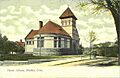
Plumb Library, c. 1905
-
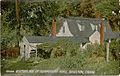
The birthplace of Isaac Hull
-
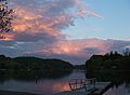
Indian Well State Park boat launch at Sunset


See also
 In Spanish: Shelton (Connecticut) para niños
