
Trumbull, Connecticut facts for kids
Quick facts for kids
Trumbull, Connecticut
|
|||
|---|---|---|---|

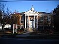
The Fairchild Nichols Memorial Library
|
|||
|
|||
| Motto(s):
Pride in our Past, Faith in our Future
|
|||
 Fairfield County and Connecticut Fairfield County and Connecticut Greater Bridgeport Planning Region and Connecticut Greater Bridgeport Planning Region and Connecticut |
|||
| Country | United States | ||
| State | Connecticut | ||
| County | Fairfield | ||
| Region | CT Metropolitan | ||
| Settled | 1639 as Stratford | ||
| Incorporated | 1797 as Trumbull | ||
| Government | |||
| • Type | First selectman-Town council | ||
| Area | |||
| • Total | 23.5 sq mi (60.9 km2) | ||
| • Land | 23.3 sq mi (60.3 km2) | ||
| • Water | 0.2 sq mi (0.6 km2) | ||
| Elevation | 266 ft (81 m) | ||
| Population
(2020)
|
|||
| • Total | 36,827 | ||
| • Density | 1,580.6/sq mi (610.3/km2) | ||
| Time zone | UTC−5 (Eastern) | ||
| • Summer (DST) | UTC−4 (Eastern) | ||
| ZIP Code |
06611
|
||
| Area code(s) | 203/475 | ||
| FIPS code | 09-77200 | ||
| GNIS feature ID | 0213518 | ||


Trumbull is a town in Fairfield County, Connecticut, USA. It's part of the Greater Bridgeport Planning Region. Trumbull shares borders with cities like Bridgeport and Shelton. It also borders the towns of Stratford, Fairfield, Easton, and Monroe.
In 2020, about 36,827 people lived in Trumbull. For thousands of years, the Golden Hill Paugussett Indian Nation called this area home. English settlers arrived in 1639. After the American Revolution, the town was named after Jonathan Trumbull (1710–1785). He was a merchant and an important leader during the war. The famous aviation pioneer Igor Sikorsky also lived in Trumbull. He designed and built the first mass-produced helicopters.
Contents
- History of Trumbull
- Geography of Trumbull
- Population and People
- Places of Worship
- Interesting Places to Visit
- Economy and Business
- Transportation in Trumbull
- Education in Trumbull
- Emergency Services
- Sports and Activities
- Media and Recognition
- Notable People from Trumbull
- Sister City
- Images for kids
- See also
History of Trumbull
The area that is now Trumbull was home to the Golden Hill Paugussett Indian Nation for thousands of years. English colonists arrived in 1639 during the Great Migration from England. They started the town of Stratford, Connecticut.
In 1725, people living in the northern part of Stratford asked to create their own village. They wanted to call it Nickol's Farms. This name came from the family who lived in the center of the area. However, the Colony of Connecticut named it Unity instead.
The village of Unity later joined with a village to its west called Long Hill. This happened in 1744, and together they formed "North Stratford." In the late 1780s, North Stratford asked for independence from Stratford. In October 1797, the Connecticut General Assembly finally made it a full town. They named it Trumbull after Jonathan Trumbull, a key figure in the American Revolution.
Geography of Trumbull
Trumbull has several natural features, including rivers, lakes, and hills.
Waterways and Lakes
The Pequonnock River is the main waterway in Trumbull. It starts near the border with Monroe. The river flows through the Pequonnock River Valley State Park and Trumbull Center. It then continues into Bridgeport.
Other important bodies of water include Canoe Brook Lake and Pinewood Lake. There are also six ponds in Twin Brooks Park.
Land and Elevation
Trumbull covers about 23.5 square miles. Most of this area is land, with a small part being water. The lowest point in town is about 40 feet above sea level at Beach Park. The highest point is Monitor Hill, which is 615 feet above sea level.
Monitor Hill (also called Tashua Hill) is considered the highest coastal point on the east coast of the United States. A special plaque on Monitor Hill Road marks this spot.
Parks and Green Spaces
Trumbull has many parks, covering over 871 acres. These parks offer places for recreation and enjoying nature.
- Abraham Nichols Park/Wood's Estate
- Aldo Memorial Park
- Robert G. Beach Memorial Park
- Davidow Park
- Great Oak Park
- Gunther Pond Park
- Indian Ledge Park
- Island Brook Park
- Kaatz Pond Park
- Kaechele Soccer Fields
- Long Hill Green
- Middlebrooks Park
- Mischee Brook Park
- Nothnagle Memorial Field
- Old Mine Park (Historic Mine Area Dedication)
- Parlor Rock Historic Amusement Area
- Strawberry Brook Estates
- Tashua Recreation Area
- Twin Brooks Park
- Unity Park
State Parks in Trumbull
In 1989, the town of Trumbull, the Connecticut Department of Environmental Protection, and the Bridgeport Hydraulic Company worked together. They bought 382 acres of land in the Pequonnock River Valley. The Department of Environmental Protection now manages this land.
Villages within Trumbull
Trumbull is made up of several smaller villages:
- Daniels Farm
- Long Hill
- Nichols
- Tashua
- Trumbull Center
Population and People
| Historical population of Trumbull | ||
|---|---|---|
| Year | Pop. | ±% |
| 1800 | 1,291 | — |
| 1810 | 1,241 | −3.9% |
| 1820 | 1,232 | −0.7% |
| 1830 | 1,242 | +0.8% |
| 1840 | 1,204 | −3.1% |
| 1850 | 1,309 | +8.7% |
| 1860 | 1,474 | +12.6% |
| 1870 | 1,335 | −9.4% |
| 1880 | 1,323 | −0.9% |
| 1890 | 1,453 | +9.8% |
| 1900 | 1,587 | +9.2% |
| 1910 | 1,642 | +3.5% |
| 1920 | 2,597 | +58.2% |
| 1930 | 3,624 | +39.5% |
| 1940 | 5,294 | +46.1% |
| 1950 | 8,641 | +63.2% |
| 1960 | 20,379 | +135.8% |
| 1970 | 31,394 | +54.1% |
| 1980 | 32,989 | +5.1% |
| 1990 | 32,016 | −2.9% |
| 2000 | 34,243 | +7.0% |
| 2010 | 36,018 | +5.2% |
| 2020 | 36,827 | +2.2% |
| U.S. Decennial Census State of Connecticut Source: U.S. Decennial Census |
||
In 2000, Trumbull had 34,243 people living in 11,911 households. About 37.5% of these households had children under 18. Most households (71.7%) were married couples. The average household had 2.8 people.
The population included 26.0% under 18 years old. About 17.3% were 65 years or older. The average age in Trumbull was 40 years.
In 2008, estimates showed about 37,134 people living in Trumbull. The population included 25.5% under 18 and 20.1% who were 65 or older. The average age was 43.4 years.
Places of Worship
- St. Catherine of Siena Church (Trumbull, Connecticut)
- St. Theresa Catholic Church (Trumbull, Connecticut)

Interesting Places to Visit
Trumbull has several notable locations, including a special fountain and historic sites.
Bicentennial Fountain and Time Capsule


The town's Bicentennial Fountain is located near the library and town hall. It has the Trumbull town seal and a plaque honoring donors. In 1997, a time capsule was placed at the fountain's base. It is set to be opened on October 12, 2097, for Trumbull's 300th anniversary.
Historic Places on the National Register
Several places in Trumbull are listed on the National Register of Historic Places. This means they are important for their history or architecture.
- Christ Episcopal Church and Tashua Burial Ground (added 2001)
- David Mallett Jr. House (added 1986)
- Nichols Farms Historic District (added 1987)
- Old Mine Park Archeological Site (added 1990)
Economy and Business
Trumbull has a strong economy with many businesses. The town's budget for 2009–2010 was over $140 million. Trumbull has about 1400 businesses.
Corporate and Retail Areas
Large companies like Helicopter Support, Sun Products, and Unilever have offices in Trumbull. The NASDAQ OMX Group also has an office here.
The Westfield Trumbull Mall is a large shopping center with over 180 stores. It is located on Route 111. The Hawley Lane Mall is another shopping area in town.
Transportation in Trumbull
Trumbull has several major roads and public transportation options.
Roads and Highways
- Route 8: This freeway goes through the southeast part of town. It connects to Waterbury and Interstate 84.
- Route 15 (the Merritt Parkway): This historic road goes north to New Haven and south towards New York City.
- Route 25: This route runs north to south. It merges with Route 8 and continues into Bridgeport.
- Route 108 (Nichols Avenue and Huntington Turnpike): This road enters Trumbull from Stratford. The Nichols Avenue part was finished in 1696, making it one of Connecticut's oldest documented highways.
- Route 111 (Main Street): This road connects Bridgeport to Newtown. It was once a toll road called the Monroe and Zoar Bridge Turnpike.
- Route 127 (White Plains Road and Church Hill Road): This road runs through the town center.
Bus and Train Services
The Greater Bridgeport Transit Authority provides bus service in Trumbull.
Three train stations are close to Trumbull:
- Bridgeport (about 4.6 miles away)
- Stratford (about 4.9 miles away)
- Fairfield Metro (about 5.7 miles away)
All three stations are served by Metro-North's New Haven Line. The Bridgeport station also has Amtrak service.
Education in Trumbull
Trumbull offers public and private education options, as well as adult learning.
Public Schools
The Trumbull Public Schools System manages the public schools. As of 2022–2023, there were 6,868 students and 512 teachers.
- High School: Trumbull High School (includes an Agriscience & Biotechnology program, Alternative High School, and REACH)
- Middle Schools: Hillcrest Middle School and Madison Middle School
- Elementary Schools: Booth Hill, Daniels Farm, Frenchtown, Jane Ryan, Middlebrook, and Tashua Elementary
- Pre-school: Trumbull Early Childhood Education Center
Private Schools
Trumbull has several private schools:
- Christian Heritage School (K–12, non-denominational)
- St. Catherine of Siena School (K–8, Catholic)
- St. Joseph High School (Catholic)
- St. Theresa School (K–8, Catholic)
- Montessori Center for Early Learning (private pre-school)
Continuing Education
Trumbull High School offers adult education classes in the evenings.
Emergency Services
Trumbull has dedicated teams for emergency medical services, fire, and police.
Emergency Medical Services (EMS)
Trumbull EMS started in 1976. It is a mix of volunteers and paid staff. Their headquarters is on Middlebrooks Avenue. Trumbull EMS uses several ambulances and paramedic vehicles. They also offer classes for EMT certification.
Fire Departments
Trumbull has three independent, all-volunteer fire departments. They handle their own funding and taxes. There are seven fire stations across the town. The current Town Fire Marshal is Megan Murphy.
- Long Hill Fire District (since 1921)
- Nichols Fire District (since 1917)
- Trumbull Center Fire District (since 1925)
Fire Station Locations
| Fire Station | Engine | Ladder | Rescue | Special Unit | Address | Neighborhood |
|---|---|---|---|---|---|---|
| Trumbull Center Fire Station # 1 | Engine 101 | Tower Ladder 104 | Rescue 100 | Service Truck 107, Gator 1 | 860 White Plains Rd. | White Plains |
| Trumbull Center Fire Station # 2 | Engine 102 | Attack 105 (Mini-Pumper) | 980 Daniels Farm Rd. | Daniels Farm | ||
| Long Hill Fire Station # 1 | Engine 206 | Rescue 200 | Service Truck 203, Polaris ATV | 6315 Main St. | Long Hill | |
| Long Hill Fire Station # 2 | Engine 205 | Tower Ladder 204 | 5404 Main St. | Town Center | ||
| Long Hill Fire Station # 3 | Squad 209 | Engine 202 (Mini-Pumper), Service Truck 208 | 4229 Madison Ave. | Madison | ||
| Nichols Fire Station # 1 | Engine 301, Engine 302, Engine 305 | Rescue 300 | 100 Shelton Rd. | Nichols | ||
| Nichols Fire Station # 2 | Squad 309 | Truck 304 | Service Truck 307 | 548 Booth Hill Rd. | Booth Hill |
Police Department
The Trumbull Police Department was created in 1941. It has eighty officers and ten civilian workers. The current Chief of Police is Michael Lombardo. The police department is located at 158 Edison Road.
Sports and Activities
Trumbull is known for its sports teams and community activities.
Notable Sports Teams
The National Little League of Trumbull won the 1989 Little League World Series. They defeated the Kang-Tu Little League from Taiwan in the championship game.
Community Organizations and Facilities
- Nichols Improvement Association: Founded in 1889, this group maintains 47 acres of open space. Their gazebo is often used for events.
- Tashua Recreation Facility: This large facility covers 268 acres. It has basketball and tennis courts, a swimming pool, and a playground. It also includes Tashua Knolls, an 18-hole golf course, and Tashua Glen, a 9-hole course.
- Trumbull Community Women: This group promotes community service and is open to women over 18. They also have a Young Women's Club.
- Town Hall Gazebo: This spot hosts concerts, especially on Tuesday nights during the summer.
- Trumbull Historical Society: Founded in 1964, this society runs a museum about Trumbull's past.
- Trumbull Nature & Arts Center: Located on Main Street, this center organizes nature-related activities like fishing trips and butterfly searches.
- Trumbull Teen Center: This center, located at Indian Ledge Park, used to offer activities like air hockey and local band concerts. Efforts are being made to reopen it.
- Trumbull's Senior Center: Located on Priscilla Place, this center provides transportation, social services, and activities for seniors.
- Society Farsharotu: This Aromanian cultural organization has its main office in Trumbull.
Trumbull Library System
The Trumbull Library System (TLS) is the town's main library. It has two locations and offers many resources. You can search for books online, borrow materials from other libraries, and use computers.
The library has over 148,000 printed books, 10,000 video materials, and 4,500 audio materials. They also have magazines, music CDs, and more.
- The Trumbull Library (main branch) is next to Town Hall.
- The Fairchild-Nichols Memorial Library is on Huntington Turnpike.
Media and Recognition
Trumbull has local media outlets and has received several awards.
Local Media
- Trumbull Community Television: Available on Charter Cable channel 17 and Frontier Communications channel 99. It shows school events, town government meetings, and community announcements.
- Public-access television: Available on Charter Cable Community Vision 192.
- The Trumbull Times: This is the local community newspaper, published every Thursday.
Filming Location
Several films and TV shows have been filmed in Trumbull:
- Isn't it Delicious? (2011)
- A Dance for Grace (2010)
- Revolutionary Road (2008)
- Oprah Winfrey presents For One More Day (2007)
Awards and Accolades
Trumbull has been recognized by several magazines:
- Family Circle magazine ranked Trumbull 7th in their "10 Best Towns for Families" in 2011.
- U.S. News & World Report magazine named Trumbull one of the best places to retire in Connecticut.
- RelocateAmerica.com included Trumbull in their "Top 100 Places to Live."
- Money magazine ranked Trumbull #68 in 2007 and #77 in 2009 in their "100 best places to live" list.
Notable People from Trumbull
Many interesting people have lived in Trumbull:

- Lee Abbamonte: A travel blogger who was the youngest American to visit all 193 UN member states.
- Dick Allen (1939–2017): An American poet and Connecticut's poet laureate.
- Craig Breslow (born 1980): A professional baseball pitcher for teams like the Oakland Athletics and Boston Red Sox. He graduated from Trumbull High School in 1998.
- Chris Drury: A professional hockey player who won the Stanley Cup and two Olympic silver medals. He was also on the 1989 Little League World Series championship team from Trumbull.
- Ted Drury: A former NHL player.
- Will Geer (1902–1978): An actor and folklorist, known for his role in "The Waltons."

- Carolyn Hax (born 1966): A writer and columnist for The Washington Post.
- Tony Horton: An actor, personal trainer, and creator of the P90X fitness program.
- Harvey Hubbell (1857–1927): A famous inventor.
- Igor Sikorsky (1889–1972): An aviation pioneer and inventor of the helicopter.
.jpg)
- Benjamin Silliman (1779–1864): The first science professor at Yale and the first to distill petroleum.
- Chris Soule: An Olympic skeleton (sport) athlete.
Sister City
Trumbull has a sister city relationship with Xinyi, Jiangsu in China. This partnership began in 2008. A plaque in Twin Brooks Park celebrates this friendship.
Images for kids
-
The Fairchild Nichols Memorial Library
-

The flag of Trumbull
-
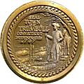
The seal of Trumbull
-
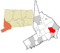
Trumbull's location within Fairfield County and Connecticut
-

Trumbull's location within the Greater Bridgeport Planning Region and the state of Connecticut
See also
 In Spanish: Trumbull (Connecticut) para niños
