
Long Hill, Trumbull, Connecticut facts for kids
Quick facts for kids
Long Hill, Connecticut
|
|
|---|---|

Long Hill marker
|
|

Long Hill, Trumbull, Connecticut
Location in Connecticut

Long Hill, Trumbull, Connecticut
Location in the United States
|
|
| Country | |
| State | Connecticut |
| County | Fairfield |
| Town | Trumbull |
| Area | |
| • Total | 8.38 km2 (3.24 sq mi) |
| • Land | 8.38 km2 (3.24 sq mi) |
| • Water | 0.0 km2 (0 sq mi) |
| Elevation | 114 m (375 ft) |
| Time zone | UTC-5 (Eastern (EST)) |
| • Summer (DST) | UTC-4 (EDT) |
| ZIP Code |
06611 (Trumbull)
|
| Area code(s) | 203/475 |
| FIPS code | 09-43580 |
| GNIS feature ID | 2805071 |
Long Hill is a neighborhood and a special area called a census-designated place (CDP) in the town of Trumbull, Connecticut. It is located in Fairfield County, west of the Pequonnock River. The main road through Long Hill is called Main Street, which is also known as Connecticut Route 111. This area was officially listed as a CDP before the 2020 census.
Contents
History of Long Hill
Long Hill was first settled as part of Stratford, Connecticut, which began in 1639. By the mid-1650s, the Golden Hill Paugussett Indian Nation asked the court of the Colony of Connecticut for payment. They wanted money for land that English settlers from Stratford were taking.
On May 15, 1656, the court set the town's boundary. It included all land about 12 miles (19 km) inland from Long Island Sound. This area was between the Housatonic River and the Fairfield town line, and it included all of Long Hill.
The English continued to buy land from the Native Americans. They recorded these land transfers. In April 1662, three men named Joseph Judson, Joseph Hawley, and John Minor got the last written land transfer from the Paugussett Indian Nation. This was for the entire western part of Trumbull, known as the "Long Hill purchase." People started getting land on Long Hill soon after 1662.
In May 1740, the farmers living at Stratfield's winter parish on Long Hill asked for their own village and parish. A "parish" was like a local church district. The legislature agreed and gave them money for education. In 1744, the Unity Parish and the Long Hill parish decided to join together. They became known as the "Society of North Stratford."
North Stratford stayed a village under the control of Stratford for 53 years. In 1797, it became part of the town of Trumbull when Trumbull officially became a town.
Long Hill Green
The Long Hill Green is a special triangle-shaped piece of land. It is where roads meet that once led to mills on the Pequonnock River in the 1700s. It also met the main road connecting Stratfield (now Bridgeport) with Newtown.
Today, these roads are Main Street (Connecticut Route 111), Broadway Road, and Whitney Avenue. A small stream called North Farrars Brook flows on the north side of the green. The green became its current size in 1801. This happened when the Bridgeport and Newtown Turnpike Company moved the road west to make it straighter.
Public Education in Long Hill
The idea of public education started early in Long Hill. On January 11, 1716, the leaders of Stratford, called "selectmen," voted to help the farmers living there. They allowed them to use money set aside for education. This was to make sure their children received schooling as required by law.
The first school district in Long Hill was created in November 1761. This district had its own committee of three people. In 1762, Long Hill was divided into two districts: Upper Long Hill and Lower Long Hill. The Lower Long Hill School closed in 1920.
On December 2, 1795, the school district set new boundaries for Long Hill South and Long Hill North. The descriptions of these new districts mentioned important places like houses, roads, and natural features. These included Canoe Brook, specific houses, and the town lines of Weston and Stratfield Parish.
Main Street's History
The road from Long Hill to Stevenson became a turnpike (a road where you pay a fee to use it) in May 1826. It was officially called the "Monroe and Zoar Bridge Turnpike." At that time, the road from Bridgeport to Trumbull was already a toll road. It was known as the Bridgeport and Newtown Turnpike and had been open since 1801.
In 1922, the Monroe and Zoar Bridge Turnpike became part of Connecticut's state highway system. It was named State Highway 308. This road ran from what is now Route 25 to Route 34. The part of the road that continued into Bridgeport was then called State Highway 122.
Today's Route 111 (Main Street) was created in 1932. It was formed from the old State Highway 308 and used to be called Long Hill Street. In 1982, a new highway, Route 25, opened. The old southern part of Route 25 in Trumbull was then renamed Route 111. The part of the road in Bridgeport went back to being managed by the town.
Industry
The Hubbell Hadley shirt factory was once a major employer in Long Hill. This means many people worked there.
Post Office
The Long Hill Post Office has been open and serving the community since at least the 1860s.
Emergency Services
The Trumbull Police Department and EMS (Emergency Medical Services) serve Long Hill. However, Long Hill also has three firehouses. The Long Hill Fire Company #1 was started in January 1921. It was officially recognized by the state on March 8, 1921.
Notable Location
- Old Mine Park Archeological Site: This is a historic mine site.
Notable People
- Harvey Hubbell (1857–1927): An inventor.
- Igor Sikorsky (1889–1972): A pioneer in aviation and the inventor of the helicopter.
Images for kids
-
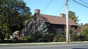
John Wildman House built between 1682 and 1745
-
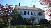
Captain Beardsley House built around 1756
-
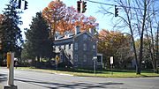
Beardsley-Morrissey House built around 1800
-
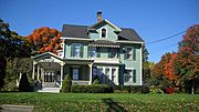
Beachcroft built around 1821
-
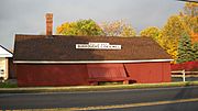
Burroughs Cider Mill built around 1884
-
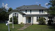
Igor Sikorsky's home built around 1934


