Wolcott, Connecticut facts for kids
Quick facts for kids
Wolcott, Connecticut
|
||
|---|---|---|
| Town of Wolcott | ||

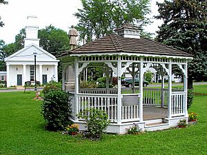
The gazebo on the Wolcott Town Green
|
||
|
||
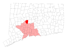
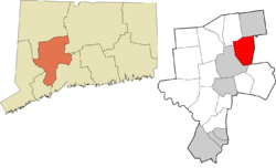
 New Haven County and Connecticut New Haven County and Connecticut |
||
| Country | ||
| U.S. state | ||
| County | New Haven | |
| Region | Naugatuck Valley | |
| Incorporated | 1796 | |
| Government | ||
| • Type | Mayor-council | |
| Area | ||
| • Total | 21.1 sq mi (54.6 km2) | |
| • Land | 20.4 sq mi (52.9 km2) | |
| • Water | 0.7 sq mi (1.8 km2) | |
| Elevation | 853 ft (260 m) | |
| Population
(2020)
|
||
| • Total | 16,142 | |
| • Density | 765.0/sq mi (295.64/km2) | |
| Time zone | UTC-5 (Eastern) | |
| • Summer (DST) | UTC-4 (Eastern) | |
| ZIP code |
06716
|
|
| Area code(s) | 203/475 | |
| FIPS code | 09-87560 | |
| GNIS feature ID | 0213538 | |
Wolcott is a town located in New Haven County, Connecticut, United States. It is part of the Naugatuck Valley Planning Region. Wolcott is mostly a residential area, meaning many people live there. In 2020, about 16,142 people lived in Wolcott.
The town was first settled in the 1730s by English colonists. It was known as Farmingbury back then. In 1796, after the United States became independent, Farmingbury became an official town and was renamed Wolcott. Some old records spell the name as Wolcutt.
Contents
History of Wolcott
How Wolcott Got Its Start
In the late 1600s, the towns of Waterbury and Farmington covered a large part of central Connecticut. The area between these two towns was called Farmingbury. This name came from combining parts of "Farmington" and "Waterbury."
People started living in Farmingbury as early as the 1730s. However, they were not officially a separate town. They were still considered part of Waterbury or Farmington.
Becoming an Independent Community
By 1770, the people of Farmingbury asked the Connecticut General Assembly for permission to create their own church society. This was called the First Ecclesiastical Society of Farmingbury. By having their own church, Farmingbury gained some religious, legal, and financial freedom. They were still part of Waterbury and Farmington politically, but they could handle some local matters themselves. This included things like collecting taxes and managing schools.
The Name Change to Wolcott
In 1796, Farmingbury asked the Connecticut General Assembly to become its own independent town. The votes were tied, with half for and half against the idea. The Lieutenant Governor, Oliver Wolcott, cast the deciding vote in favor of Farmingbury. Because of his important vote, the residents renamed their new town "Wolcott" in his honor. The first official count of people in Wolcott happened in 1800. It showed that 948 people lived there.
The 1962 Tornado Event
On May 24, 1962, a very strong tornado hit Wolcott. It was an F3 tornado, which means it caused a lot of damage. Many buildings, homes, businesses, and cars were damaged or destroyed. Trees were blown down, and a large refrigeration truck was even thrown into a power pole. This caused a power outage in the area. Sadly, one person died and 50 people were hurt during this storm.
Geography and Nature
Wolcott's Size and Landscape
According to the United States Census Bureau, Wolcott covers a total area of about 21.1 square miles (54.6 square kilometers). Most of this area, about 20.4 square miles (52.9 square kilometers), is land. The remaining 0.7 square miles (1.8 square kilometers) is water.
Lakes and Reservoirs
Wolcott does not have any large natural lakes. However, there are several man-made reservoirs. These were created by building dams on smaller rivers and streams.
- Scovill Reservoir: Also known as Woodtick Reservoir, this covers 121 acres. It was made by damming the Mad River. It was built in 1917 to provide water for a brass manufacturing company. Today, it is owned by the town and used for fun activities like boating and fishing.
- Other Reservoirs: Parts of Chestnut Hill Reservoir, Hitchcock Lake, Southington Reservoir #2, New Britain Reservoir, Cedar Lake, and Dunham Mill Pond are also in Wolcott.
Highest Point in the County
The highest point in all of New Haven County is found in Wolcott. It's called Lindsley Hill, and it is about 1,046 feet (319 meters) above sea level.
How Land is Used in Wolcott
Wolcott has mostly grown into a residential, suburban town. This means many people live in homes there, and it's close to a larger city. About 56% of the town's land is still undeveloped, meaning it's natural land or open space. About 33% of the town is used for homes, with most of them being single-family houses. A smaller part of the town, about 11%, is used for farms, businesses, factories, parks, and town buildings.
Notable People from Wolcott
Many interesting people have connections to Wolcott:
- Amos Bronson Alcott (1799–1888): Born in Wolcott, he was a teacher and writer. He was also the father of famous author Louisa May Alcott.
- William Andrus Alcott (1798–1859): Also born in Wolcott, he was a teacher and wrote over 100 books.
- Anthony Fantano (born 1985): A music critic and internet personality who grew up in Wolcott.
- Jahana Hayes (born 1973): A U.S. congresswoman who lives in Wolcott.
- Seth Thomas (1785–1859): Born in Wolcott, he became a very well-known clock maker.
Education in Wolcott
The Wolcott Public Schools system has five public schools:
- Elementary Schools (Grades Pre-K–5):
- Alcott Elementary School – Their mascot is the "All Star."
- Frisbie Elementary School – Their mascot is the "Bee."
- Wakelee Elementary School – Their mascot is the "Wildcat."
- Middle School (Grades 6–8):
- Tyrrell Middle School (TMS) – Their mascot is the "Tornado."
- High School (Grades 9–12):
- Wolcott High School (WHS) – Their mascot is the "Eagle." In 2014, it was ranked among the top schools in the nation.
Town Services and Transportation
Getting Around Wolcott
The main roads in Wolcott are CT Route 69 and CT Route 322. Both of these roads connect to I-84, a major highway. The highway exits 23 and 28 are less than 2 miles outside of Wolcott.
Wolcott Police Department
The Wolcott Police Department (WPD) is located on Nichols Road. The Chief of Police is Edward Stephens. The department has several special teams and programs, including:
- An Honor Guard
- An Emergency Response Team
- A Detective Division
- An Accident Investigative Team
- A Patrol Division
- School Resource Officers (who work in schools)
- A Motorcycle Unit
- A Neighborhood Watch program
- The D.A.R.E. program (which teaches kids about avoiding drugs and violence)
- Wolcott Police Explorers (for teens interested in becoming police officers)
- An Animal Control Unit
Since 2015, Wolcott police officers have been using body cameras to record their interactions with the public.
See also
 In Spanish: Wolcott (Connecticut) para niños
 | Charles R. Drew |
 | Benjamin Banneker |
 | Jane C. Wright |
 | Roger Arliner Young |


