Bethany, Connecticut facts for kids
Quick facts for kids
Bethany, Connecticut
|
||
|---|---|---|

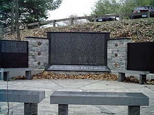
Bethany Veterans Wall of Honor
|
||
|
||
| Motto(s):
"Rural Is Beautiful"
|
||
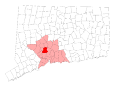
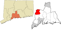
 New Haven County and Connecticut New Haven County and Connecticut |
||
| Country | ||
| U.S. state | ||
| County | New Haven | |
| Region | South Central CT | |
| Incorporated | 1832 | |
| Government | ||
| • Type | Selectman-town meeting | |
| Area | ||
| • Total | 21.4 sq mi (55.4 km2) | |
| • Land | 21.0 sq mi (54.3 km2) | |
| • Water | 0.4 sq mi (1.0 km2) | |
| Elevation | 574 ft (175 m) | |
| Population
(2020)
|
||
| • Total | 5,297 | |
| • Density | 247.5/sq mi (95.61/km2) | |
| Time zone | UTC-5 (Eastern) | |
| • Summer (DST) | UTC-4 (Eastern) | |
| ZIP code |
06524
|
|
| Area codes | 203/475 | |
| FIPS code | 09-04580 | |
| GNIS feature ID | 0213389 | |
Bethany is a small town located in New Haven County, Connecticut, United States. It's part of the South Central Connecticut Planning Region. In 2020, about 5,297 people lived there. Bethany is known for keeping its quiet, country feel.
Contents
History of Bethany
Early Settlement and Growth
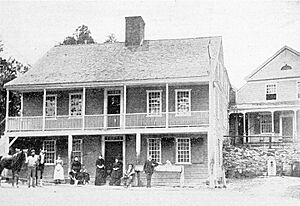
Bethany was first settled in 1717. However, it didn't become its own official town until May 1832. Before that, it was part of Woodbridge. Even today, Bethany is a peaceful, mostly residential town. It still has some farms and places where dairy cows are raised. Many reservoirs are also found here, providing water to nearby cities like Naugatuck and New Haven.
People lived in the Bethany area even before 1638. These were mainly Native American tribes like the Naugatucks and Mattabessitts. The first European settlers arrived around April 1638. They created the towns of Milford and New Haven. The boundary between these two towns ran right through what is now Bethany.
In 1717, the area became known as Amity Parish. Then, in 1832, Bethany officially became a town. Its name comes from a place mentioned in the Bible.
Changes Over Time
In the late 1800s, Bethany's population and land size got smaller. Some parts of the town were added to Woodbridge. Also, a new town called Beacon Falls was created nearby. The population continued to drop until the 1940s, when it started to grow again.
In 1923, the Bethany Airport opened. It was one of the first airports in New England. Soon after, a local Boy Scout troop was formed. The town also started its own police and volunteer fire departments.
Schools and Community
In 1954, a high school was built in Woodbridge. It served students from Woodbridge, Bethany, and Orange. Before this, Bethany students went to high schools in other towns. In 1963, Amity Junior High School was built right in Bethany.
Bethany Community School was finished in 1970. It replaced many of the older, smaller schools. For safety reasons, some of the very old, four-room schools were later closed.
In 2007, Connecticut Magazine named Bethany the #1 Small Town in Connecticut.
Town Seal Symbolism
Bethany's town seal is a special design created in 1982 for its 150th anniversary. It shows a circle with the words "TOWN OF BETHANY CONNECTICUT" and "INCORPORATED 1832." Inside, there's a road surrounded by trees. On one side, you can see Christ Episcopal Church. On the other side is the First Church of Christ Congregational. This seal was designed by local artist Betsy Seaton.
Town Protection
Bethany has a dedicated police officer who works for the town. The State Police also have a station nearby. Together, they help keep the town and its surrounding areas safe.
Geography
Bethany covers a total area of about 21.4 square miles (55.4 km2). Most of this is land, about 21.0 square miles (54.3 km2). The rest, about 0.4 square miles (1.0 km2), is water.
Population Information
| Historical population | |||
|---|---|---|---|
| Census | Pop. | %± | |
| 1850 | 914 | — | |
| 1860 | 974 | 6.6% | |
| 1870 | 1,135 | 16.5% | |
| 1880 | 637 | −43.9% | |
| 1890 | 550 | −13.7% | |
| 1900 | 517 | −6.0% | |
| 1910 | 495 | −4.3% | |
| 1920 | 411 | −17.0% | |
| 1930 | 480 | 16.8% | |
| 1940 | 706 | 47.1% | |
| 1950 | 1,318 | 86.7% | |
| 1960 | 2,384 | 80.9% | |
| 1970 | 3,857 | 61.8% | |
| 1980 | 4,330 | 12.3% | |
| 1990 | 4,608 | 6.4% | |
| 2000 | 5,040 | 9.4% | |
| 2010 | 5,563 | 10.4% | |
| 2020 | 5,297 | −4.8% | |
| U.S. Decennial Census | |||
As of the 2010 Census, Bethany had 5,563 people. Most residents, about 91.6%, were white. About 1.9% were black or African American, and 4.8% were Asian. About 2.5% of the population identified as Hispanic or Latino.
In 2000, there were 5,040 people living in Bethany. There were 1,755 households, and 1,449 of these were families. About 40.2% of households had children under 18. Most households (73.8%) were married couples. The average household had 2.87 people.
The median age in Bethany was 41 years old. About 27.3% of the population was under 18. The median income for a household was $74,898. For families, it was $79,493.
Parks and Recreation
Bethany has a place called Veterans Memorial Park. Between 1997 and 1999, the town bought 165 acres of land to create this park. In 1999, Hockanum Lake, a man-made lake in the park, was opened for swimming. The park also hosts community events like the Summer Sparkler.
Notable People
Many interesting people have connections to Bethany:
- Amy Arnsten, a neuroscientist who studies the brain.
- Robert Crabtree, a well-known chemist.
- David Hoadley (1774–1839), an architect who designed buildings in Connecticut.
- Silas Hoadley (1786–1870), a famous clockmaker who was born in Bethany.
- R. W. B. Lewis (1917–2002), a writer and professor at Yale University.
- Quincy Porter (1897–1966), a composer who won a Pulitzer Prize.
- Katharine Weber, a talented novelist.
See also
 In Spanish: Bethany (Connecticut) para niños
 | Isaac Myers |
 | D. Hamilton Jackson |
 | A. Philip Randolph |


