
Woodbridge, Connecticut facts for kids
Quick facts for kids
Woodbridge, Connecticut
|
|||
|---|---|---|---|
| Town of Woodbridge | |||

Darling House Museum, built in 1774
|
|||
|
|||
 New Haven County and Connecticut New Haven County and Connecticut South Central Connecticut Planning Region and Connecticut South Central Connecticut Planning Region and Connecticut |
|||
| Country | |||
| U.S. state | |||
| County | New Haven | ||
| Region | South Central CT | ||
| Incorporated | 1784 | ||
| Government | |||
| • Type | Selectman-town meeting | ||
| Area | |||
| • Total | 19.2 sq mi (49.7 km2) | ||
| • Land | 18.8 sq mi (48.8 km2) | ||
| • Water | 0.4 sq mi (1.0 km2) | ||
| Elevation | 348 ft (106 m) | ||
| Population
(2020)
|
|||
| • Total | 9,087 | ||
| • Density | 473.3/sq mi (182.84/km2) | ||
| Time zone | UTC-5 (Eastern) | ||
| • Summer (DST) | UTC-4 (Eastern) | ||
| ZIP code |
06525
|
||
| Area code(s) | 203/475 | ||
| FIPS code | 09-87700 | ||
| GNIS feature ID | 0213539 | ||


Woodbridge is a town in New Haven County, Connecticut, United States. It is part of the South Central Connecticut Planning Region. In 2020, about 9,087 people lived there.
The town center of Woodbridge is a special historic place. It is listed on the National Register of Historic Places as the Woodbridge Green Historic District. Woodbridge is also known for its schools. It is part of the Amity Regional School District #5, which was named a top school district in Connecticut in 2021.
Contents
History of Woodbridge
Woodbridge was first called "Amity." It was created in 1739 from parts of land that belonged to New Haven and Milford. In 1742, a minister named Benjamin Woodbridge started working there. The town was later named after him. Woodbridge officially became a town in 1784.
Early Settlers and Hideouts
In 1661, Woodbridge was a secret hiding spot for some important people. These were three judges who had signed the death warrant for King Charles I of England. The remains of their hideout can still be found today. It is on the West Rock ridge, which is along the eastern edge of the town.
Thomas Darling (1720–1789) moved to Woodbridge in 1774. He was a teacher at Yale College and later a businessman. His old home is now the Darling House Museum. The museum is run by the Amity & Woodbridge Historical Society. The first farms in Woodbridge were in an area called The Flats, located in the West River Valley.
In more recent times, Woodbridge has grown into a suburban area. This means more people moved from cities to live in homes with yards. The town has also worked to allow more types of housing. This helps more people live in the town.
Education
Woodbridge has good schools for its young residents.
Elementary School
Beecher Road School is the elementary school for Woodbridge. It teaches students from pre-kindergarten up to the 6th grade.
Middle School
Woodbridge is part of the Amity school system. This means it shares a middle school with the town of Bethany. Bethany is located just north of Woodbridge.
High School
Students from Woodbridge also go to Amity Regional High School. This high school is shared with the nearby towns of Bethany and Orange. The high school building is located right in the center of Woodbridge.
Woodbridge is also home to Ezra Academy. This is a Jewish day school that serves students from many towns. Students come from 21 different towns in New Haven and Fairfield counties to attend Ezra Academy.
Geography
Woodbridge is about 19.2 square miles (49.7 square kilometers) in total size. Most of this area, about 18.8 square miles (48.8 square kilometers), is land. The rest, about 0.4 square miles (1.0 square kilometer), is water.
The town is sometimes thought of in two main parts. There is central Woodbridge, which is the western, hilly side of town. Then there is The Flats. This area is on the eastern side, next to West Rock and the New Haven neighborhood of Westville.
Woodbridge has several towns as neighbors:
- To the north: Bethany
- To the east: Hamden
- To the southeast: New Haven and West Haven
- To the south: Orange
- To the west: Derby, Ansonia, and Seymour
Parks and Hiking Trails

Woodbridge has many beautiful natural areas. Several groups work to protect these lands and historic sites. These groups include the Woodbridge Land Trust and the Woodbridge Park Association.
The town has many hiking trails that are open to everyone. Two notable places are:
- The Alice Newton Street Memorial Park, which is 93 acres (38 hectares).
- The Wepawaug Falls area, which is 22 acres (9 hectares).
Some of this land has been given to the town by its residents.
Population and People
| Historical population | |||
|---|---|---|---|
| Census | Pop. | %± | |
| 1820 | 1,988 | — | |
| 1850 | 912 | — | |
| 1860 | 872 | −4.4% | |
| 1870 | 829 | −4.9% | |
| 1880 | 926 | 11.7% | |
| 1890 | 926 | 0.0% | |
| 1900 | 852 | −8.0% | |
| 1910 | 878 | 3.1% | |
| 1920 | 1,170 | 33.3% | |
| 1930 | 1,630 | 39.3% | |
| 1940 | 2,262 | 38.8% | |
| 1950 | 2,822 | 24.8% | |
| 1960 | 5,182 | 83.6% | |
| 1970 | 7,673 | 48.1% | |
| 1980 | 7,761 | 1.1% | |
| 1990 | 7,924 | 2.1% | |
| 2000 | 8,983 | 13.4% | |
| 2010 | 8,990 | 0.1% | |
| 2020 | 9,087 | 1.1% | |
| U.S. Decennial Census | |||
In 2020, Woodbridge had a population of 9,087 people. There were 2,897 households in the town. Most households, about 70%, were married couples. About 36% of households had at least one person under 18 years old. The average family size was 3.31 people.
The median age in Woodbridge was 49.3 years. This means half the people were younger than 49.3, and half were older. About 23.2% of the population was under 18 years old. About 24.8% of the population was 65 years or older.
Other Interesting Facts
- The sulfur match was invented in Woodbridge. Samuel Beecher and Thomas Sanford created it in 1835.
- Woodbridge is sometimes mentioned on the TV show Gilmore Girls. It is shown as a town near the fictional Stars Hollow.
- Because it is close to Yale University and has good schools, Woodbridge is known as a very educated town in Connecticut. In 2011, it had the highest percentage of residents with advanced degrees in the state.
Notable People
Many interesting people have lived in Woodbridge:
- Guido Calabresi, a judge and professor at Yale Law School.
- David Gelernter, an author and computer science professor at Yale.
- Suzanne Greco, a businesswoman.
- John Hollander, a poet and literary critic.
- Dorit Kemsley, a fashion designer and TV personality.
- David Aaron Kessler, a doctor and former head of the FDA.
- Bun Lai, who created the first sustainable sushi in the world.
- Jeremy Leven, a Hollywood writer, director, and novelist.
- Jonathan Mostow, a film director and producer.
- Bernie S. Siegel, an author and surgeon.
- Maury Yeston, a Broadway composer who won Tony Awards.
- Josh Zeid, an American-Israeli baseball player.
Notable Locations
Several places in Woodbridge are so important that they are listed on the National Register of Historic Places. This means they are protected for their historical value.
- Darling House Museum – added in 1979.
- Dr. Andrew Castle House – added in 2000.
- New England Cement Company Kiln and Quarry – added in 2001.
- Woodbridge Green Historic District – added in 2003.
- Chatfield Farmstead – added in 2010.
- James Alexis Darling House – added in 2020.
Images for kids
-
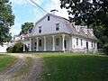
The Darling House Museum, a historic landmark in Woodbridge.
-

The flag of Woodbridge, Connecticut.
-
The official seal of the Town of Woodbridge.
-
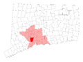
Map showing Woodbridge's location within New Haven County and Connecticut.
-
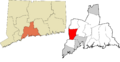
Map showing Woodbridge's location within the South Central Connecticut Planning Region.
See also
 In Spanish: Woodbridge (Connecticut) para niños
