
Sleeping Giant (Connecticut) facts for kids
Quick facts for kids Sleeping Giant |
|
|---|---|

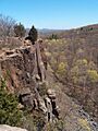
View from the Giant's Chin
|
|
| Highest point | |
| Elevation | 739 ft (225 m) |
| Geography | |

Sleeping Giant
Location in Connecticut
|
|
| Parent range | Metacomet Ridge |
| Geology | |
| Age of rock | 200 Ma |
| Mountain type | Fault-block; igneous |
| Climbing | |
| Easiest route | Casual uphill walk (via Tower Path) |
Sleeping Giant (also known as Mount Carmel) is a cool mountain made of a special type of rock called traprock. It stands about 739 feet (225 m) tall. You can find it about eight miles (13 km) north of New Haven, Connecticut.
This mountain is super famous because it looks just like a person sleeping when you see it from far away, either from the north or the south! People love the Sleeping Giant for its amazing views from the top of its cliffs. It also has unique mini-ecosystems, which are like tiny worlds with their own plants and animals. Most of the mountain is part of Sleeping Giant State Park. It's a popular spot for fun outdoor activities. There are over 30 miles (48 km) of hiking trails, including 5 miles (8 km) of the 23-mile (37 km) Quinnipiac Trail. Quinnipiac University is right at the bottom of the mountain in Hamden.
Contents
Geography of Sleeping Giant Mountain
The Sleeping Giant mountain is about 2.75 miles (4.43 km) long and 1.75 miles (2.82 km) wide. It's mostly in Hamden, with a small part reaching into Wallingford. The mountain's shape clearly shows a "head," "chin," "chest," "hip," "knee," and "feet." These parts are made of rocky outcrops and ridge tops.
The highest point is the Left Hip, which is 739 ft (225 m) high. Next is the Chest, at 710 ft (220 m). The Left Knee and Right Leg are both 700 ft (210 m) tall. The Giant's Head is 670 ft (200 m) and has a huge 400 ft (120 m) cliff.
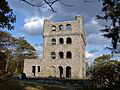
There's a stone observation tower on the Left Hip. It was built in the 1930s by a group called the Works Progress Administration. From the tower, you can see amazing 360-degree views of the Mill and Quinnipiac River valleys around the mountain. An old rock quarry, which closed in 1933, is now part of the state park. It left some marks on the Giant's Head.
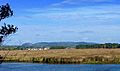
The Sleeping Giant is part of a long, narrow ridge called the Metacomet Ridge. This ridge stretches from Long Island Sound all the way north through the Connecticut River Valley of Massachusetts to the Vermont border. West and south of Sleeping Giant, the Metacomet Ridge continues as Rocky Top and West Rock Ridge. Water from the west side of Sleeping Giant flows into the Mill River, then to New Haven Harbor and Long Island Sound. Water from the east side flows into the Quinnipiac River, also leading to New Haven Harbor and Long Island Sound.
Geology: How Sleeping Giant Was Formed


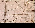
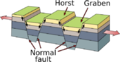
Sleeping Giant is a fault-block ridge. This means it formed when huge blocks of rock moved along cracks in the Earth's crust. This happened about 200 million years ago during the Triassic and Jurassic periods. The mountain is made of a rock called traprock, also known as basalt. Basalt is an extrusive volcanic rock, meaning it came out of volcanoes. Sometimes, small earthquakes are felt here.
Basalt is usually a dark rock. But the iron inside it rusts when it touches the air, making the cliffs look reddish. Basalt often breaks into cool shapes like octagons and pentagons, which look like stacks of posts. You can see huge slopes of broken basalt rocks, called scree, below many of the cliffs on Sleeping Giant.
The basalt cliffs were created by several massive lava flows. These flows were hundreds of feet deep! They came up through cracks in the Earth when North America was pulling away from Eurasia and Africa. These lava floods happened over 20 million years. Between the eruptions, layers of dirt and sand built up. These layers eventually turned into sedimentary rock.
Imagine a layer cake: the basalt was like the cake layers, and the sedimentary rock was like the frosting. Over time, this "layer cake" of rock tilted and cracked. Then, the softer sedimentary layers wore away faster than the hard basalt layers. This left the tilted edges of the basalt layers exposed, creating the distinct ridge and dramatic cliffs you see today.
Ecosystems and Wildlife
Sleeping Giant has a mix of microclimates, which are small areas with different weather conditions. This is quite unusual for New England.
- Dry, hot upper ridges: These areas have oak savannas, which are like grasslands with scattered trees. You'll often see chestnut oak trees here, along with different grasses and ferns. Eastern red cedar trees, which love dry places, grow on the bare edges of the cliffs.
- Lower eastern slopes: These slopes have oak-hickory forests, similar to the forests in the surrounding lowlands.
- Narrow ravines: These deep, narrow valleys are filled with eastern hemlock trees. These trees block the sunlight, making the ravines damp and cool. This allows plants that prefer cooler climates to grow there.
- Talus slopes: These are slopes made of broken rocks. They are rich in nutrients and support many plants that need calcium, which are rare in eastern Connecticut.
Because the mountain has so many different types of land, it's home to several plant and animal species that are rare or protected in the state or even globally. Sleeping Giant is also an important path for raptors (like hawks and eagles) when they migrate each season.
The Legend of Sleeping Giant
According to the Native Americans of the Quinnipiac Tribe, there's a legend about the Sleeping Giant. They say a giant stone spirit named Hobbomock (or Hobomock) was a powerful but sometimes angry figure in their stories. One day, he got really mad because his people were treated badly. He stomped his foot down so hard that he changed the path of the Connecticut River! (That's why the river suddenly turns east in Middletown, Connecticut after flowing south for a long time).
To stop Hobbomock from causing more trouble, a good spirit named Keitan cast a spell on him. The spell made Hobbomock sleep forever, turning him into the man-like shape of the Sleeping Giant we see today.
This legend has even inspired books! Eleanor Estes wrote a story called The Sleeping Giant in her 1948 collection. And Jason J. Marchi retold the legend (with some fun changes) in his children's book The Legend of Hobbomock: The Sleeping Giant, published in 2015.
History of Sleeping Giant State Park
| Sleeping Giant State Park | |
|---|---|

The "Sleeping Giant" in profile
|
|

Sleeping Giant State Park
Location in Connecticut
|
|
| Location | Hamden, Connecticut, United States |
| Area | 1,465 acres (5.93 km2) |
| Elevation | 522 ft (159 m) |
| Designation | Connecticut state park |
| Established | 1924 |
| Administrator | Connecticut Department of Energy and Environmental Protection |
| Website | Sleeping Giant State Park |
|
Sleeping Giant Tower
|
|

Lookout tower at the summit of the Giant
|
|
| Location | Hamden, Connecticut |
| Built | 1936 |
| Architect | Works Progress Administration |
| Architectural style | Romanesque |
| MPS | Connecticut State Park and Forest Depression-Era Federal Work Relief Programs Structures TR |
| NRHP reference No. | 86001754 |
| Added to NRHP | September 4, 1986 |
In the mid-1800s, people in New England started to really appreciate mountains. They saw them as a peaceful escape from busy cities and factories. This was inspired by artists and thinkers of the time. Many summer cottages were built on the Sleeping Giant and other nearby mountains.
In 1888, a man named John H. Dickerman built a road for horse-drawn carriages on the Giant. He opened a place called Blue Hills Park. He would even host picnics with ice cream on the cliffs for people living nearby!
Protecting the Giant
The effort to protect the Sleeping Giant started in 1924. A group of local people formed the Sleeping Giant Park Association (SGPA). They were worried because a company was digging up traprock from the Giant's head. A cottage owner had rented his land to the Mount Carmel Traprock Company to get building materials.
Blasting away parts of the beloved mountain made people very angry. Local newspapers reported on it a lot. Under the leadership of James W. Toumey, a professor from Yale University, the SGPA fought against the quarrying for ten years. In 1933, during the Great Depression, the SGPA bought the land for $30,000. People donated money to help, and the property became Sleeping Giant State Park.
Sleeping Giant State Park officially began in 1924. The SGPA gave 600 acres of land to the Park and Forest Commission. The state bought another 65 acres that same year for $7025.00.
In 1936, the famous Sleeping Giant Tower was built at the top of the mountain. It was built by the Works Progress Administration, a government program that created jobs during the Great Depression. The tower was added to the National Register of Historic Places in 1986.
Recent Events: The 2018 Storm
On May 15, 2018, a very strong storm called a "microburst" hit the park. It caused a lot of damage, and the park had to close for a long time. At first, people thought it was a tornado. But the National Weather Service later said the tornado ended just west of the park. It turned into a 100-mph microburst by the time it reached Sleeping Giant. This microburst was half a mile wide and traveled for seven miles. Almost every pine tree in the main picnic area was knocked down. After more than a year of cleaning up, the park finally reopened on June 14, 2019.
Fun Activities at Sleeping Giant State Park
Sleeping Giant State Park is a super popular place for outdoor fun for people in the greater New Haven area. From the clifftops, you can see far across much of New Haven County and even some of Hartford County. On clear days, you can even see across Long Island Sound to the Shoreham area on Long Island!
The state park is open every day until sunset, all year round. During warmer months, there's a parking fee on weekends and holidays (it was $4 to $15 in 2016).
You can do lots of cool things on the Giant, like:
- Hiking
- Rock climbing (it was closed for a while but reopened in 2015!)
- Snowshoeing
- Picnicking
- Bird watching
There are also special trails for horseback riding and cross-country skiing on the lower parts of the mountain. You can even go fishing in the Mill River, which is right next to the park.
The 23-mile (37 km) Quinnipiac Trail is the oldest trail in the 700-mile (1,100 km) blue blazed trail system. This system is managed by the Connecticut Forest and Park Association. The Quinnipiac Trail goes all the way across the Giant, from the Quinnipiac River, over the mountain's highest points, to the Mill River. Then it continues north over West Rock Ridge and Mount Sanford.
If you want to camp, only youth camping is allowed on the Giant, and you need a permit. The park also has restrooms, a picnic shelter, and picnic tables during certain seasons.
Protecting Sleeping Giant for the Future
Most of the Sleeping Giant has been protected, but not all of it. The trails and facilities in Sleeping Giant State Park are taken care of by both the Sleeping Giant Park Association (SGPA) and the State of Connecticut. The SGPA does most of the trail maintenance.
Sleeping Giant State Park covers about 1,500 acres (6.1 km2). The SGPA is still working hard to get more land to add to the park. The SGPA has also played a big part in stopping people from cutting down trees on the Giant, building cell towers on its peaks, and even trying to close the state park completely. The SGPA also leads regular hikes and educational walks on the Giant. They also have volunteer programs to help maintain the trails. The Connecticut Forest and Park Association also helps a lot with protecting the Giant and building trails there.
Images for kids
-
View from the Giant's Chin
-
Close-up of traprock on the Sleeping Giant
-
Faulting
-
The "Sleeping Giant" in profile
-
Lookout tower at the summit of the Giant
