
Quinnipiac River facts for kids
Quick facts for kids Quinnipiac River |
|
|---|---|

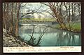
The Quinnipiac River, as seen looking west (upstream) from "Red Bridge" in Meriden, Connecticut
|
|
| Other name(s) | Dragon River, East River, New Haven River |
| Country | United States |
| State | Connecticut |
| Region | New Haven, Hartford |
| District | North Haven, Wallingford, Cheshire, Southington, Plainville |
| Cities | New Haven, Meriden |
| Physical characteristics | |
| Main source | Deadwood Swamp Farmington, Connecticut, Hartford County, Connecticut, United States 335 ft (102 m) 41°41′42″N 072°48′55″W / 41.69500°N 72.81528°W |
| River mouth | New Haven Harbor, New Haven, Connecticut Long Island Sound, New Haven County, Connecticut, United States 0 ft (0 m) 41°17′58″N 072°54′14″W / 41.29944°N 72.90389°W |
| Length | 45.5 mi (73.2 km) |
The Quinnipiac River is a river in Connecticut, United States. It is about 45.5 mi (73.2 km) long. The river starts in West Central Connecticut from a place called Dead Wood Swamp, near the city of New Britain.
It flows generally south through several towns. These include Plainville, Southington, and Cheshire. It also passes west of Meriden, and through Wallingford and Yalesville. Finally, it flows into New Haven Harbor, which is part of Long Island Sound, near New Haven.
Contents
The Quinnipiac River's Past

The name "Quinnipiac" comes from an old Native American language. It means "long water land." This name was used for both the river and the area around where it meets the sea. Europeans first found the river in 1614.
Why Was it Called the Dragon River?
By the early 1700s, early settlers started calling the Quinnipiac River the "Dragon River." This was because of the many seals that lived there. People at that time sometimes called seals "sea dragons." These seals were likely harbor seals. However, old bones found show that much larger gray seals also lived near the river's mouth as recently as the 1500s.
River System and Flow
The Quinnipiac River watershed is the area of land that drains into the river. It covers about 165 square miles (430 km2). There are four old dams along the river. These dams make it hard for boats to travel along the river.
Dams and Hydroelectric Power
The first dam is near Plantsville. The second is at Hanover Pond in South Meriden. The third dam is in northeast Yalesville. The fourth is at the south end of Community Lake in Wallingford. In 2017, a small power plant was built at Hanover Pond. It uses a special screw to make electricity from the river's flow.
Enjoying the River: Paddling and Tides
Paddling is a popular activity on the Quinnipiac River. Many people enjoy kayaking or canoeing, especially in the tidal marsh area in North Haven. The river's water level changes with the ocean's tide. This tidal change can be seen up to 14 miles (23 km) upstream from where the river meets the sea.
River Health and Protection
For a long time, in the 1800s and 1900s, the river had serious pollution problems. This was due to many factories and towns along its banks. The Quinnipiac was the first river in Connecticut to get special rules to stop pollution.
Early Efforts to Clean Up the River
In 1886, the state government made a rule. It stopped the city of Meriden from dumping raw sewage directly into the river. Because of this rule, the state's second sewage treatment plant was built in 1891.
Modern Clean-Up and Challenges
Even with these efforts, by 1914, most fish had disappeared from the river's mouth. Things got better after the Connecticut Clean Water Act of 1967 and the Water Pollution Control Act of 1972. These laws helped clean up the river. They led to better ways of treating sewage and factory waste. For example, levels of copper in the river have dropped a lot since the 1980s. However, Combined sewer overflows from New Haven are still a big problem for the river's mouth.
Fun Things to Do
The Quinnipiac Trail runs along the west side of the Quinnipiac River. You can find this trail in the Quinnipiac River State Park in North Haven. It's a great place for walking and enjoying nature.
How to Cross the Quinnipiac River
Many roads and highways cross the Quinnipiac River. Here are some of the main crossings:
| County | Town | Carrying |
|---|---|---|
| Hartford | Plainville | |
| Crooked Street (SSR 536) | ||
| Woodford Avenue (SSR 536) | ||
| Tomlinson Avenue | ||
| Stillwell Drive | ||
| Shuttlemeadow Road | ||
| Southington | Route 10 | |
| Newell Street | ||
| West Queen Street | ||
| Spring Street | ||
| Lazy Lane | ||
| Curtiss Street | ||
| Hart Street | ||
| Mill Street | ||
| Center Street | ||
| West Center Street | ||
| West Main Street | ||
| Atwater Street | ||
| Route 10 | ||
| Old Turnpike Road. | ||
| New Haven | Cheshire | |
| East Johnson Avenue | ||
| Blacks Road | ||
| Cheshire Street | ||
| Meriden | Oregon Road | |
| Main Street | ||
| Wallingford | Oak Street | |
| Quinnipiac Street | ||
| Toelles Road | ||
| North Haven | ||
| Broadway | ||
| Sackett Point Road | ||
| New Haven | Middletown Avenue | |
| Grand Avenue | ||
| Ferry Street | ||
Images for kids
-
Bridge in Wallingford, 1907

