
Quinebaug River facts for kids
Quick facts for kids Quinebaug River |
|
|---|---|
 |
|
| Country | United States |
| State | Connecticut, Massachusetts |
| Counties | New London, CT, Windham, CT, Worcester, MA, Hampden, MA |
| Physical characteristics | |
| Main source | Holland Pond 42°04′55″N 72°09′49″W / 42.082071°N 72.163666°W Holland, Hampden County, Massachusetts, United States 645 ft (197 m) |
| River mouth | Empties into Shetucket River 41°33′22″N 72°02′46″W / 41.556°N 72.046°W Preston and Lisbon, New London County, Connecticut, United States 30 ft (9.1 m) |
| Basin features | |
| Tributaries |
|
_map.jpg)

The Quinebaug River is a river in the eastern part of Connecticut and south-central Massachusetts. Its waters also flow from western Rhode Island. The name "Quinebaug" comes from the Native American language of southern New England. It means "long pond." The river is one of the main rivers in the Quinebaug and Shetucket Rivers Valley National Heritage Corridor. This area is known for its natural beauty and history.
Contents
River's Journey: Where the Quinebaug Flows
The Quinebaug River is about 69 miles (111 km) long. It starts from East Brimfield Lake and other ponds in Sturbridge, Massachusetts. The river then flows mostly southeast and south. It passes through many towns in Connecticut, including Putnam, Danielson, Plainfield, Canterbury, and Jewett City.
The river joins Aspinook Pond between Canterbury and Jewett City. After that, it flows into the Shetucket River near Norwich. The Shetucket River then empties into the Thames River. Finally, the Thames River flows into the Long Island Sound.
Along its path, the river has several dams. These include East Brimfield Dam, Westville Dam, and West Thompson Lake. These dams help control floods. Many smaller dams were built long ago to power mills. Some of these dams still create hydroelectric power today.
River's Home: The Quinebaug Watershed
The Quinebaug River watershed covers about 850 square miles (2,200 square kilometers). A watershed is an area of land where all the water drains into a single river or body of water. This watershed even reaches into western Rhode Island.
The area around the river is mostly covered by forests. There are 29 named streams that flow into the Quinebaug. Six of these are major tributaries. These include the French River, Moosup River, and Five Mile River.
The watershed also has 54 lakes and ponds. About 31 of these are larger than 10 acres (4 hectares). In total, these water bodies cover about 3,000 acres (12 square kilometers). The biggest lake is East Brimfield Reservoir. It is located in Brimfield and Sturbridge and covers 420 acres (1.7 square kilometers).
Fish and Wildlife in the Watershed
The Quinebaug River watershed is home to many types of fish. You can find trout, smallmouth bass, largemouth bass, northern pike, and panfish here. The land around the river also supports various wildlife.
Exploring the River: Paddling Adventures
If you love being on the water, the Quinebaug River is a great place for canoeing and kayaking. Three parts of the river have been named National Recreation Trails by the National Park Service. These were some of the first water trails to get this special title.
The designated sections are:
- From Holland Pond to East Brimfield Reservoir (in Holland and Brimfield, Massachusetts).
- From Paper Mill Dam in Dudley to West Thompson Lake.
- From Simonzi Park in Putnam to Aspinook Pond in Canterbury.
The East Coast Greenway, a long trail for walking and biking, also follows parts of the river.
Places to Launch Your Boat
You can launch your canoe or kayak at several spots along the river:
- Pond Bridge Road, Holland
- US Route 20 boat ramp, Brimfield
- Old Mashapaug Road, Sturbridge
- West Dudley Road, Dudley
- Fabyan Road, Thompson
- West Thompson Lake boat ramp, Thompson
- Simonzi Park on Kennedy Drive, Putnam
- Route 101, Pomfret
- Riverside Park off Day Street, Brooklyn
- Town Park off Route 12, Killingly
- Quinebaug Trout Hatchery, Plainfield
- Robert Manship Park off Route 14, Canterbury
- Butts Bridge Road, Canterbury
Images for kids
-
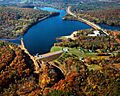
Brimfield Lake and Dam on the Quinebaug River in Hampden County, Massachusetts
-
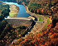
Westville Lake and Dam on the Quinebaug River in Worcester County, Massachusetts


